Inertial sensor tracking system

a technology of inertial sensor and tracking system, which is applied in direction finders, navigation instruments, instruments using radio waves, etc., can solve the problem of lack of an accurate system for tracking underground mine personnel

Inactive Publication Date: 2007-10-18
INSET SYST
View PDF8 Cites 44 Cited by
  • Summary
  • Abstract
  • Description
  • Claims
  • Application Information

AI Technical Summary

Problems solved by technology

There exists the lack of an accurate system for tracking un...

Method used


Image

  • Inertial sensor tracking system
  • Inertial sensor tracking system
  • Inertial sensor tracking system

Examples


Embodiment Construction

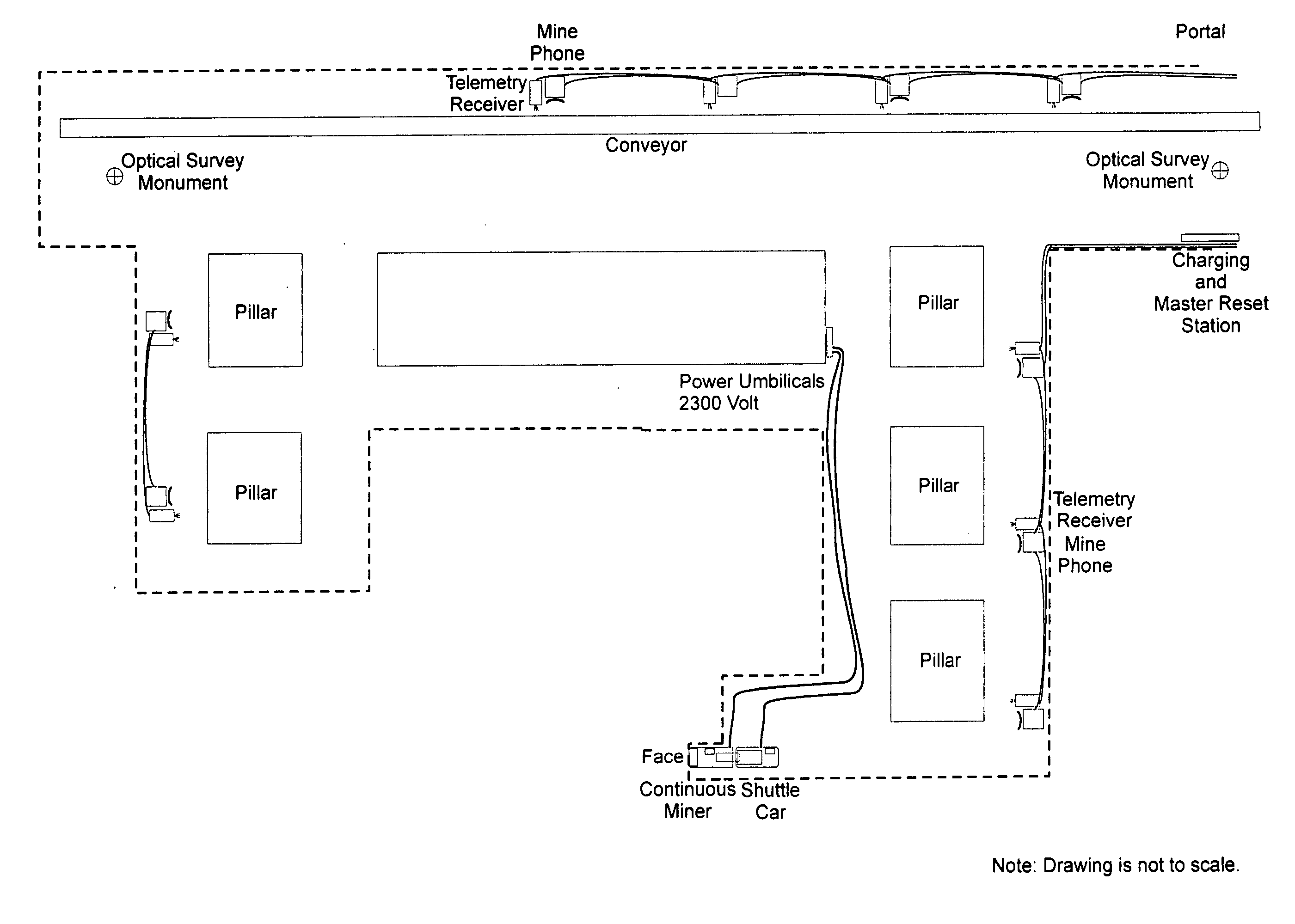
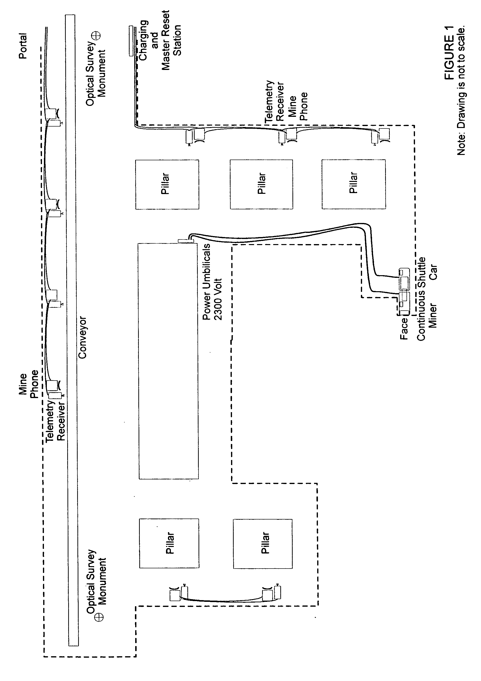
[0024] The INERTIAL SENSOR TRACKING SYSTEM is an underground mine personnel and machinery tracking system consisting of Wireless Body Pack Transmitters, Machinery Mounted Inertial Sensors, Telemetry Transceivers, Computer Equipment, Monitor Equipment, Specialized Software Applications, and Emergency Power Generation Equipment. FIG. 1 depicts the INERTIAL SENSOR TRACKING SYSTEM installed in an underground mine environment. FIG. 1 indicates the overall concept of the installation of the underground equipment.

[0025] The Wireless Body Pack Transmitter

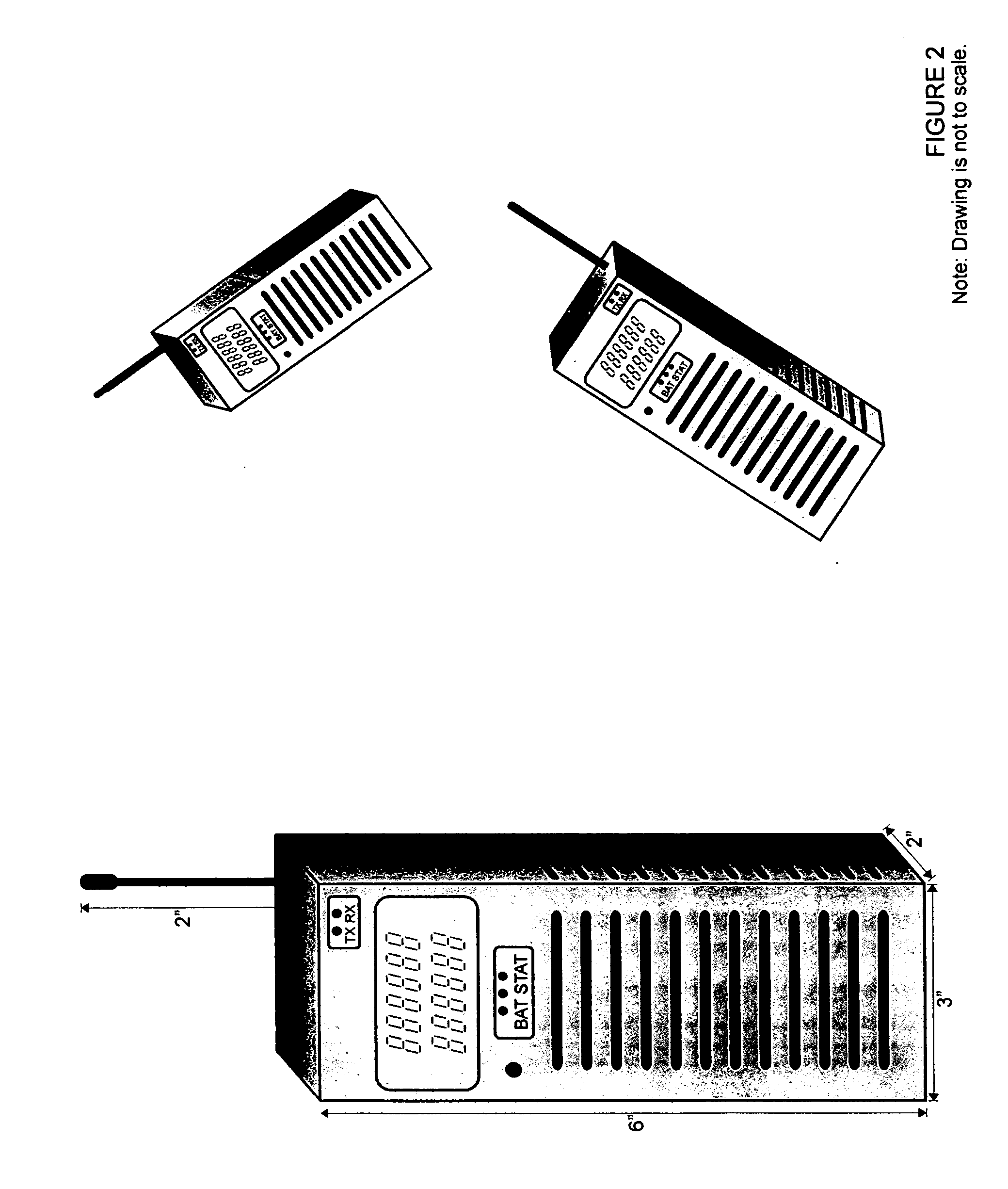
[0026] The Wireless Body Pack Transmitter is an inertial sensing device and transmitter, powered by battery cells. FIG. 2 depicts the Wireless Body Pack Transmitter. This device is worn by the underground mine personnel, and transmits telemetric velocity data. The Wireless Body Pack Transmitter has indicators for BATTERY status, TRANSMIT / RECEIVE status, and a liquid crystal display. The device has a short neoprene titanium external antenn...


PUM


Abstract

The INERTIAL SENSOR TRACKING SYSTEM is an overall system installation consisting of wireless body pack transmitters, broadband telemetry transceivers, computer and monitoring equipment, and emergency power generation for tracking personnel in an underground mine environment. The system is designed to function with normal primary power and on battery operation in the event of an emergency. In the past inertial sensors have been large spinning mass gyroscopes and large mass-based accelerometers. These inertial sensors have required high voltage three phase electrical supplies. The “wearable” body pack must be battery operated and the sensors must be small and lightweight. Micro-Electro-Mechanical (MEM) sensors fulfill both the requirements of low weight and low power consumption. The accuracy of the MEM sensor has been developed sufficiently to incorporate, with de-noising algorithms, an accurate position-sensing device. The proliferation of broadband TCP/IP protocol based RF systems provides a standardized medium of transmission, which will work in an underground environment.

Description

TITLE OF INVENTION [0001] The “INERTIAL SENSOR TRACKING SYSTEM” for underground mine tracking, is the concept and design of Russell M. Breeding, Virginia Beach, Va., USA and has no affiliation with any previous underground mine personnel or machinery tracking device. The “INERTIAL SENSOR TRACKING SYSTEM” is also known as the “INSET SYSTEM”BACKGROUND OF THE INVENTION [0002] There exists the lack of an accurate system for tracking underground mine personnel, particularly in an emergency situation. Accepted methods of above-ground navigation are celestial, visual, satellite, hyperbolic radio, and RADAR navigation are inoperable underground. Due to the most recent, January 2006, underground mine explosion and fires, and the subsequent lack of information as to the location of the underground mine personnel, an accurate method of tracking underground mine personnel is necessary to provide rescue personnel with the location of the trapped personnel. Due to the limitations of existing navi...

Claims


Application Information

Patent Timeline
IPC IPC(8): G08B1/08G01C21/00G08B23/00G01S19/35
CPCG01C19/66G08B21/02G07C9/00111G07C9/28
Inventor BREEDING, RUSSELL MARK
Owner INSET SYST
Why Eureka
Try Eureka