Ionosphere modeling apparatus and methods

a technology of ionosphere and model, applied in the field of global navigation satellite systems, can solve the problems of not providing detailed structure to obtain differential corrections across local networks, and achieve the effects of improving error estimates, rapid convergence, and high reliability

Active Publication Date: 2009-09-10
TRIMBLE NAVIGATION LTD
View PDF5 Cites 94 Cited by
  • Summary
  • Abstract
  • Description
  • Claims
  • Application Information

AI Technical Summary

Benefits of technology

[0022]In contrast, embodiments in accordance with the invention exploit correlations in the ionosphere at the filtering level. A set of parameters is introduced to characterize the ionosphere to a sufficient degree. These parameters are elements of a state vector which is estimated from the data using a Kalman filtering algorithm. For network situations with more than four stations, this leads to a smaller number of parameters to be estimated than in prior art approaches and therefore to more rapid convergence, both for the ionosphere's parameters as well for as the carrier-phase integer ambiguities. As a result, error estimates are improved. This leads to higher reliability of the extracted integer ambiguity being the correct integer number of wavelengths from satellite to receiver.

Problems solved by technology

The prior-art Nequick 3D model discussed above attempts to trace the large scale ionospheric variation across the globe, but does not deliver the detailed structure to obtain differential corrections across local networks.

Method used


Image

  • Ionosphere modeling apparatus and methods
  • Ionosphere modeling apparatus and methods
  • Ionosphere modeling apparatus and methods

Examples


Embodiment Construction

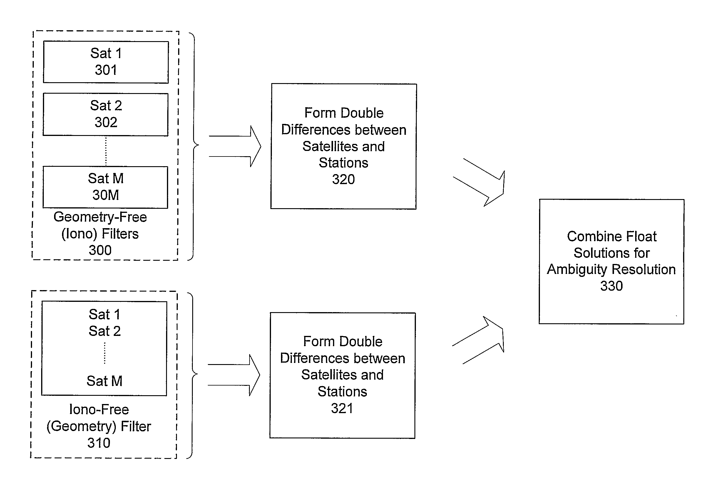
[0043]Embodiments in accordance with the invention employ a novel approach to ionospheric modeling together with efficient algorithms that improve on prior-art models. Phase measurements of signals of at least two wavelengths, as acquired by a network of GNSS reference stations, are used in a geometry-free linear combination.

[0044]An illustrative embodiment uses the two wavelengths k1 and X2 on the respective frequency bands L1 and L2 of the current NAVSTAR Global Positioning System (GPS). However, principles of the invention can be applied to any GNSS system supplying signals on two or more frequencies, such as the Russian-deployed GLONASS system or the planned Galileo system. The model presented here is also applicable for the signals on three or more frequencies that will be supplied by the modernized GPS system and the Galileo system. For three or more carrier frequencies, a different linear combination of the phase measurements is processed in a filter equivalent to the one pre...


PUM


Abstract

Methods and apparatus which characterize the ionospheric error across a network of GNSS reference stations are presented. The method relies on dual-frequency phase measurements in a geometry-free linear combination. The data are filtered for ambiguities and the characteristic parameters of the ionosphere. In combination with filter results from other combinations of phase measurements (ionosphere free combination), the physically-based model provides rapid and reliable ambiguity resolution.

Description

CROSS REFERENCE TO RELATED APPLICATIONS[0001]Benefit is claimed of the filing date of Provisional U.S. Patent Application 60 / 715,752 filed 9 Sep. 2005.TECHNICAL FIELD[0002]The present invention relates to the field of Global Navigation Satellite Systems. More particularly, the present invention relates to ionospheric modeling and ambiguity resolution of GNSS signals for two or more carriers.BACKGROUND ART[0003]Global Navigation Satellite Systems (GNSS) include the Global Positioning System (GPS), the Glonass system, and the proposed Galileo system. Each GPS satellite transmits continuously using two radio frequencies in the L-band, referred to as L1 and L2, at respective frequencies of 1575.41 MHz and 1227.60 MHz. Two signals are transmitted on L1, one for civil users and the other for users authorized by the Unites States Department of Defense (DoD). One signal is transmitted on L2, intended only for DoD-authorized users. Each GPS signal has a carrier at the L1 and L2 frequency, a ...

Claims


Application Information

Patent Timeline
Patent Type & Authority Applications(United States)
IPC IPC(8): G01S5/14G01S19/32G01S19/04G01S19/44
CPCG01S19/04G01S19/44G01S19/32G01S19/071
Inventor KOLB, PETER F.
Owner TRIMBLE NAVIGATION LTD
Why Eureka
Try Eureka