System and method for position determination

a technology of position determination and method, applied in the field of method and system for determining the position of objects, can solve the problems of difficult model, difficult to predict the overall accuracy which can be obtained over a region, and the accuracy of three-dimensional measurements in the world coordinate system is not accurate depending on the distance, so as to achieve efficient, stable and reliable devices, and high absolute positional accuracy.

Inactive Publication Date: 2010-01-21
GAUTAMA SIDHARTA
View PDF6 Cites 75 Cited by
  • Summary
  • Abstract
  • Description
  • Claims
  • Application Information

AI Technical Summary

Benefits of technology

[0053]It is an advantage of the present invention that accurate three dimensional measurements in world coordinate system can be obtained based on video images recorded from a mobile support. It is an advantage of the system and method used that a user, e.g. land surveyor, can digitally map object boundaries in the field without being on that location, e.g. from behind his desk, with a high absolute positional accuracy, e.g. an accuracy better than 30 cm, preferably better than 25 cm, more preferably better than 20 cm, even more preferably better than 15 cm, still more preferably better than 10 cm.
[0054]It is an advantage of embodiments according to the present invention that external geographic information can be used for production of new position determination information data.
[0055]Particular and preferred aspects of the invention are set out in the accompanying independent and dependent claims. Features from the dependent claims may be combined with features of the independent claims and with features of other depend...

Problems solved by technology

Therefore, an important bottleneck in the use of mobile mapping systems in inventory and surveying applications is the positional accuracy that can be associated with the sensor data.
3D measurement of field objects in the stereo images will be less accurate depending on the distance to the camera.
The overall accuracy which can be obtained over a region is difficult to predict since the impact of the en...

Method used


Image

  • System and method for position determination
  • System and method for position determination
  • System and method for position determination

Examples


Embodiment Construction

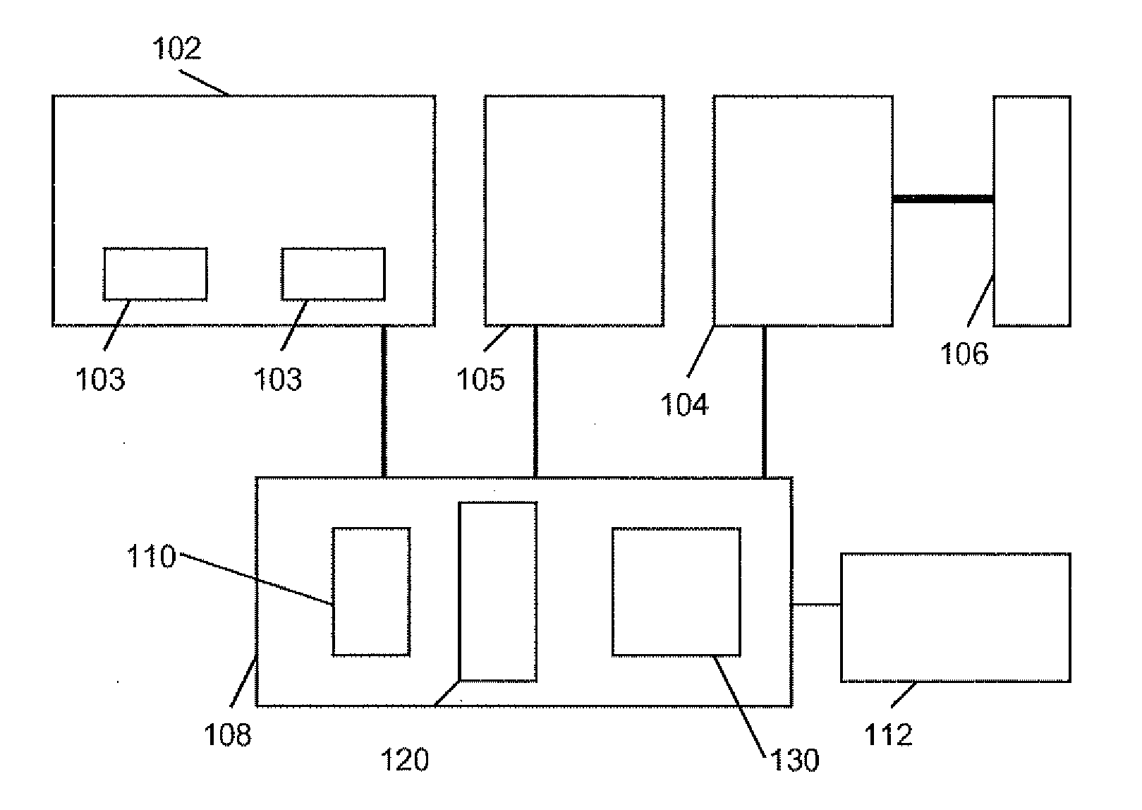
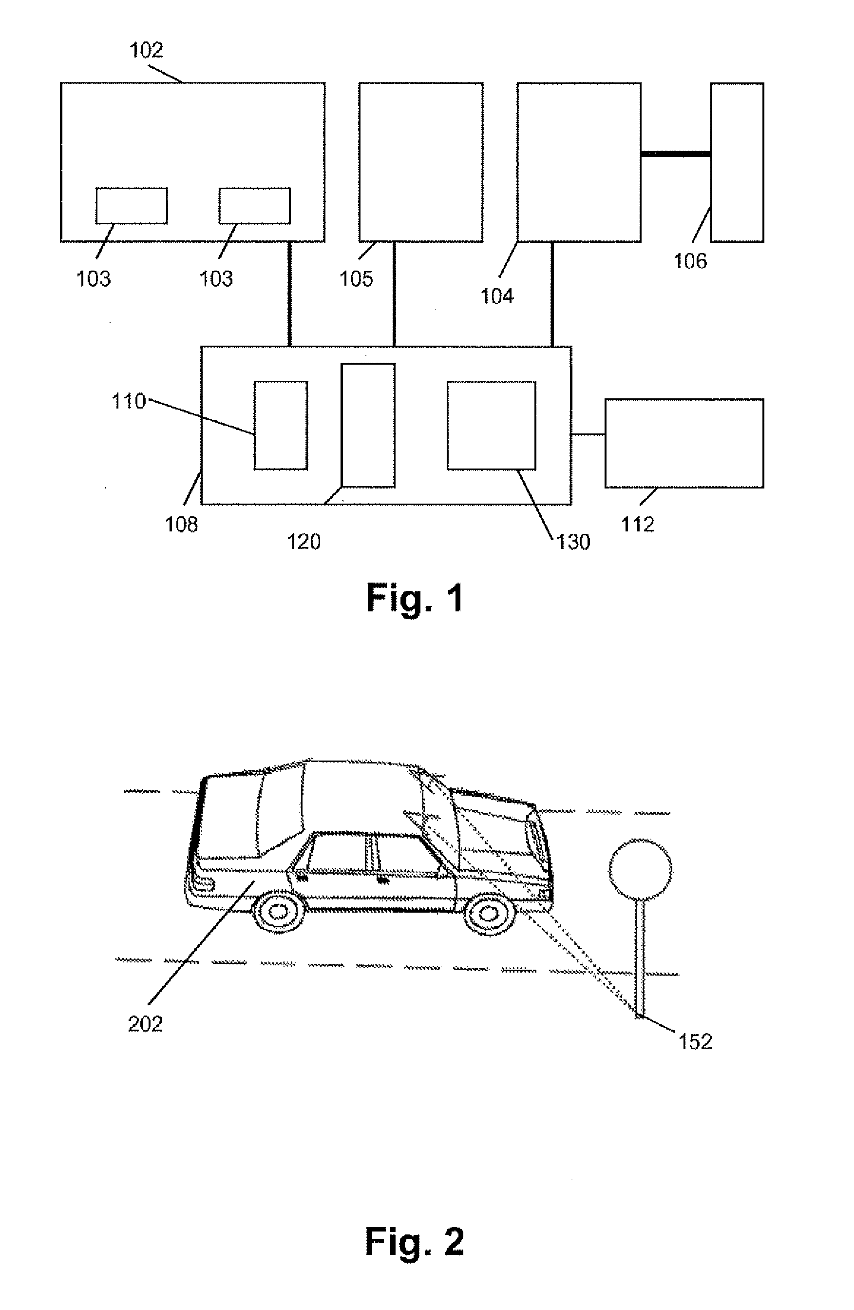
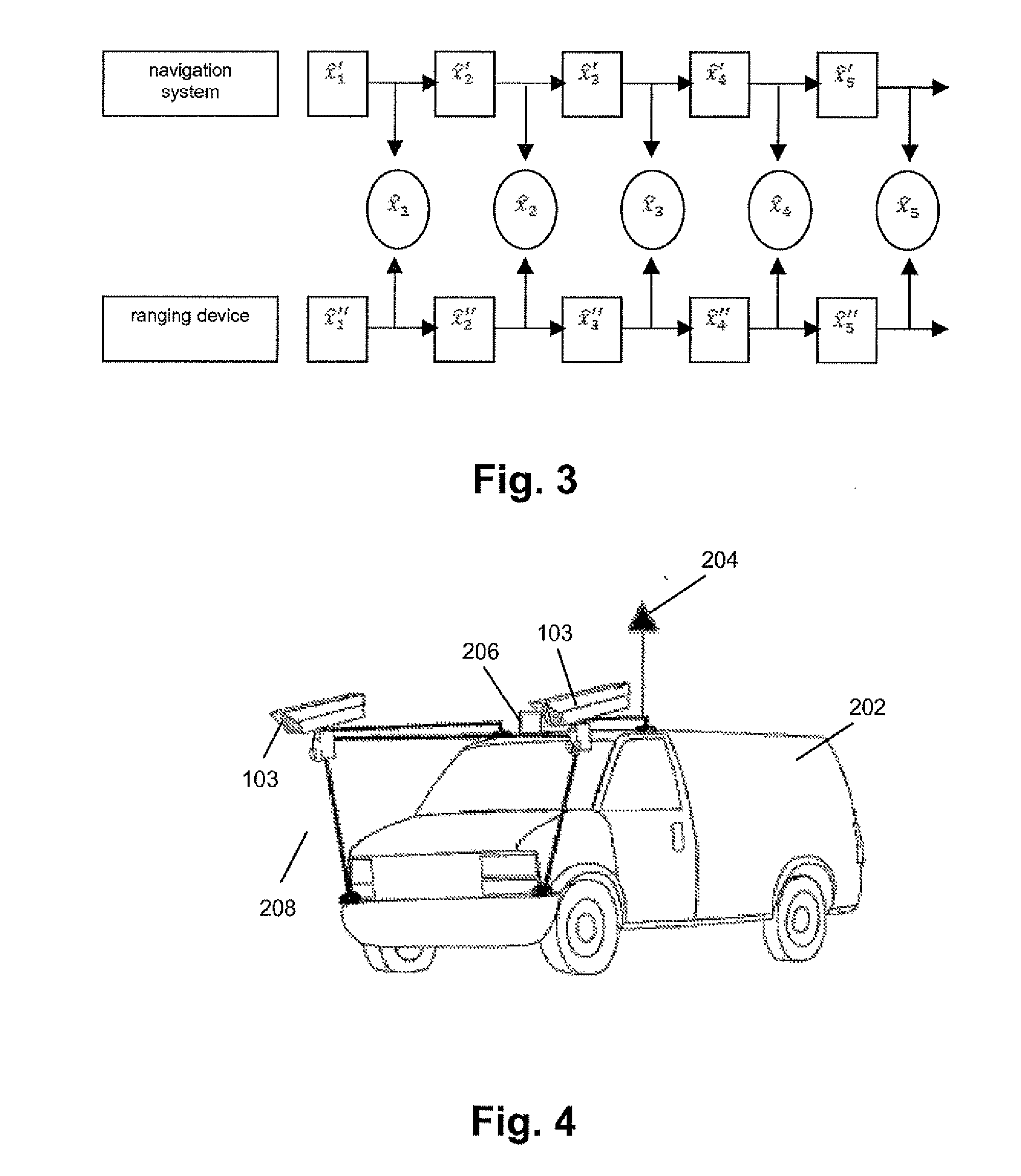
[0071]The present invention will be described with respect to particular embodiments and with reference to certain drawings but the invention is not limited thereto but only by the claims. The drawings described are only schematic and are non-limiting. In the drawings, the size of some of the elements may be exaggerated and not drawn on scale for illustrative purposes. The dimensions and the relative dimensions do not correspond to actual reductions to practice of the invention.

[0072]Furthermore, the terms first, second and the like in the description and in the claims, are used for distinguishing between similar elements and not necessarily for describing a sequence, either temporally, spatially, in ranking or in any other manner. It is to be understood that the terms so used are interchangeable under appropriate circumstances and that the embodiments of the invention described herein are capable of operation in other sequences than described or illustrated herein.

[0073]It is to be...


PUM


Abstract

The present invention relates to generating position determination information. A corresponding system comprises an image receiving means (102) for obtaining at least one image of the environment, and a control point information obtaining means (104) for obtaining control point position information about a position of at least one control point (152) in the environment. The system also comprises an image processing means (108) for associating said control point position information about a position of the at least one control point (152) in the environment to an image of the at least one control point (152) in the at least one image of the environment and for deriving, from the at least one image of the environment, position information of at least one object (202) in the environment taking into account the associated position information of the image of the at least one control point (152). An accuracy control means allows controlling the obtained accuracy by controlling the control points used.

Description

TECHNICAL FIELD OF THE INVENTION[0001]The present invention relates to a method and system for determining positions of objects, e.g. in a three dimensional environment. More particularly, the present invention relates to a method and system for determining a position of an object using a mobile system, e.g. for mapping and navigation.BACKGROUND OF THE INVENTION[0002]To date, the use of mapping systems and street-level geospatial imaging, e.g. for use in motor vehicles or for imaging purposes, has been widely spread and still is rapidly growing. This imposes not only the requirement that more and more areas can be mapped appropriately, but it also imposes additional requirements regarding accuracy, resulting in a need for efficient and reliable systems for generating position determination and / or mapping information having a high level of accuracy. Therefore, an important bottleneck in the use of mobile mapping systems in inventory and surveying applications is the positional accura...

Claims


Application Information

Patent Timeline
IPC IPC(8): G01C21/00G06K9/00
CPCG01C21/28G01C15/00
Inventor GAUTAMA, SIDHARTA
Owner GAUTAMA SIDHARTA
Why Eureka
Try Eureka