Concept for localizing a position on a path

a technology of path and concept, applied in direction finders using radio waves, navigation instruments, instruments, etc., can solve the problems of inability to achieve the desired average accuracy, etc., to achieve the effect of minimal computational requirements, easy understanding, and little technical experien

Active Publication Date: 2010-04-22
FRAUNHOFER GESELLSCHAFT ZUR FOERDERUNG DER ANGEWANDTEN FORSCHUNG EV
View PDF8 Cites 50 Cited by
  • Summary
  • Abstract
  • Description
  • Claims
  • Application Information

AI Technical Summary

Benefits of technology

[0021]It is an advantage of the present invention that the inventive concept for localizing a position may do without positional reference. Consequently, no maps of an environment or a data acquisition phase, like, e.g., learning with so-called RF fingerprinting (database with transmitter position in trilateration) may be used. A user may, for example, be guided by intuitive commands or by visualization (for example by colors indicating how well his or her own movement matches the trail) or also by audio signals.
[0022]It is a further advantage of the present invention that the inventive concept is easily understandable with little technical experience.
[0023]If comparing the determined properties of the radio signals at the position with the previously recorded properties characterizing a reference path is executed, for example on a central server, minimal computational requirements are made with regard to a mobile terminal device, like, for example, a PDA. Thus, the inventive concept may also be used, apart from PDAs and mobile telephones, for very small platforms without displays, like, e.g., wireless radio nodes in sensor networks, iPods, etc.
[0024]It is a further advantage of the present invention that an inventive localization or navigation system which, for example, includes a mobile terminal device and a server, may be used in any environment with wireless networks without any preparation and is additionally completely independent of a network technology. An exchange of reference path information may be preformed via any network. For applications of the inventive concept containing no guidance to a communication partner of the user, like, e.g., finding back to a car, no network access and no server for data exchange is may be employed, since all functionalities, i.e. determining the properties of the radio signals, comparing the determined properties to previously recorded properties and determining the relationship between the position and the reference path, may be executed on the mobile terminal device.
[0025]It is a further advantage of the present invention that no maps of the environment with coordinates are needed, which are frequently not available and have to be generated in a cost- and time-consuming way, in particular for an indoor area. With conventional guidance systems based on localization, maps of the environment may be employed to be able to identify passable ways. Otherwise, routes would be calculated which, due to obstacles, cannot be used as trails in practice. The inventive concept is freed from this requirement for maps of the environment, as only trails are considered which were already covered successfully by users. In particular, an assessment of real walking distances is also possible by the inventive concept without maps of the environment.

Problems solved by technology

The GPS system is currently only reliably available for outdoors.
Currently, these technologies do not yet have the desired average accuracies.
Generally, infrared systems and RFID systems are not available everywhere and are tied to specific preconditions.
If, for example, persons with mobile terminal devices or also self-sufficient systems, like, for example, automotive vehicles or robots, are in a strange environment and want to find other persons, defined places or objects or to be guided to the same, or, for example, be guided back to a starting point without complicated explanations of the way, and if the respective current positions of the persons and objects as well as a map of the environment are either not known or available, respectively, the above-described conventional localization or navigation methods will fail.

Method used


Image

  • Concept for localizing a position on a path
  • Concept for localizing a position on a path
  • Concept for localizing a position on a path

Examples


Embodiment Construction

[0055]With regard to the following description, it should be noted that like or seemingly like functional elements have the same reference numerals in the different embodiments and that thus the descriptions of these functional elements are mutually interchangeable in the different embodiments illustrated in the following.

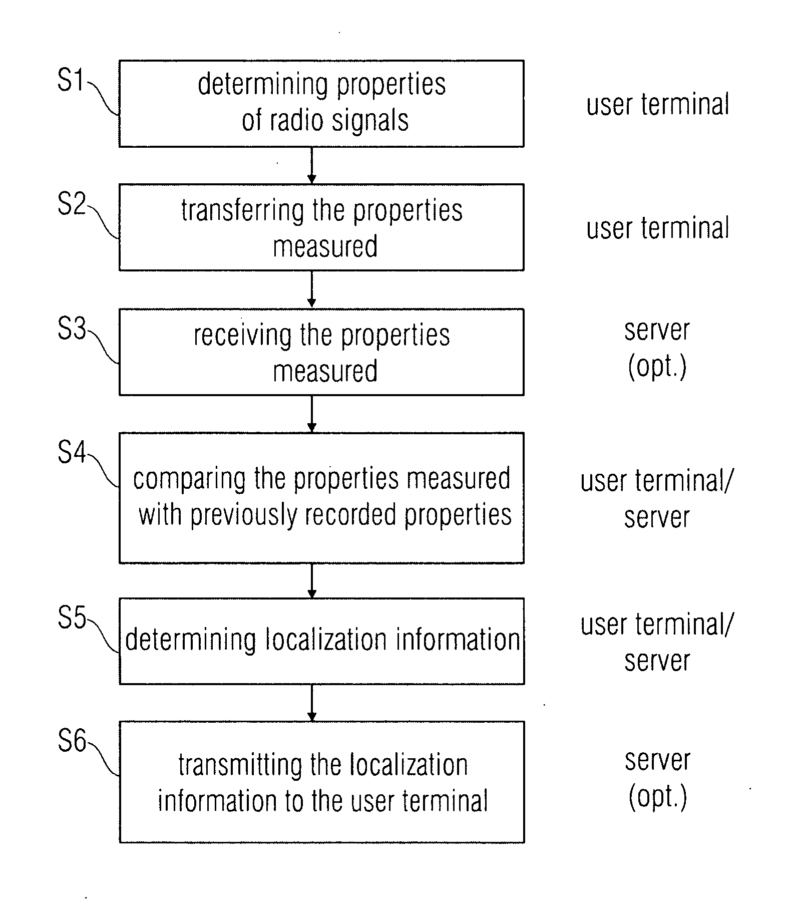
[0056]In the following, with reference to FIGS. 1 to 24, the inventive concept for localizing a position on a trail is described, wherein radio signals from fixedly positioned radio transmitters may be received along the path. In this respect, FIG. 1 first of all shows a flowchart for illustrating a method for localizing a position on a trail according to an embodiment of the present invention.

[0057]The method for localizing illustrated in FIG. 1 comprises a first step S1 of determining properties of the radio signals of the fixedly positioned radio transmitters at the position of the mobile device or client, respectively. Thereupon, according to embodiments, a sec...


PUM


Abstract

An apparatus for localizing a position on a path, radio signals of fixedly positioned radio transmitters being receivable along the path, the apparatus including a determiner for determining properties of the radio signals of the fixedly positioned radio transmitters at the position, and a comparator for comparing the determined electromagnetic properties with previously recorded properties which characterize a reference path, and for determining a relation between the position and the reference path on the basis of a result of the comparison.

Description

[0001]The present invention relates to a concept for localizing a position on a path, wherein radio signals may be received along the path from fixedly positioned radio transmitters, as it can be used in particular for localizing or navigating mobile terminal devices in a wireless communication network.BACKGROUND OF THE INVENTION[0002]Different location technologies are available for finding persons with mobile terminal devices. The most widely known system for outdoor localization or navigation, respectively, is the satellite-aided Global Positioning System (GPS). For localization or navigation within buildings or indoors, respectively, different approaches are known, like, for example, infrared systems, RFID systems or also field strength evaluations by IEEE 802.11 WLAN networks (WLAN=wireless local area network). The GPS system is currently only reliably available for outdoors. New developments, like highly sensitive receivers or the so-called A-GPS (assisted GPS) represent attem...

Claims


Application Information

Patent Timeline
Patent Type & Authority Applications(United States)
IPC IPC(8): G01S5/02
CPCG01S5/0252G01C21/206
Inventor LOIDL, KARINMEYER, STEFFENHUPP, JUERGEN
Owner FRAUNHOFER GESELLSCHAFT ZUR FOERDERUNG DER ANGEWANDTEN FORSCHUNG EV
Why Eureka
Try Eureka