
Method for positioning portable communication device

a communication device and portable technology, applied in the field of positioning methods, can solve the problems of erroneous calculated distance, different from the actual distance, and inability to meet the actual condition of electromagnetic wave propagation models mentioned above, and achieve the effect of reducing errors

Inactive Publication Date: 2010-06-03
INVENTEC APPLIANCES CORP
View PDF7 Cites 16 Cited by
  • Summary
  • Abstract
  • Description
  • Claims
  • Application Information

AI Technical Summary

Benefits of technology

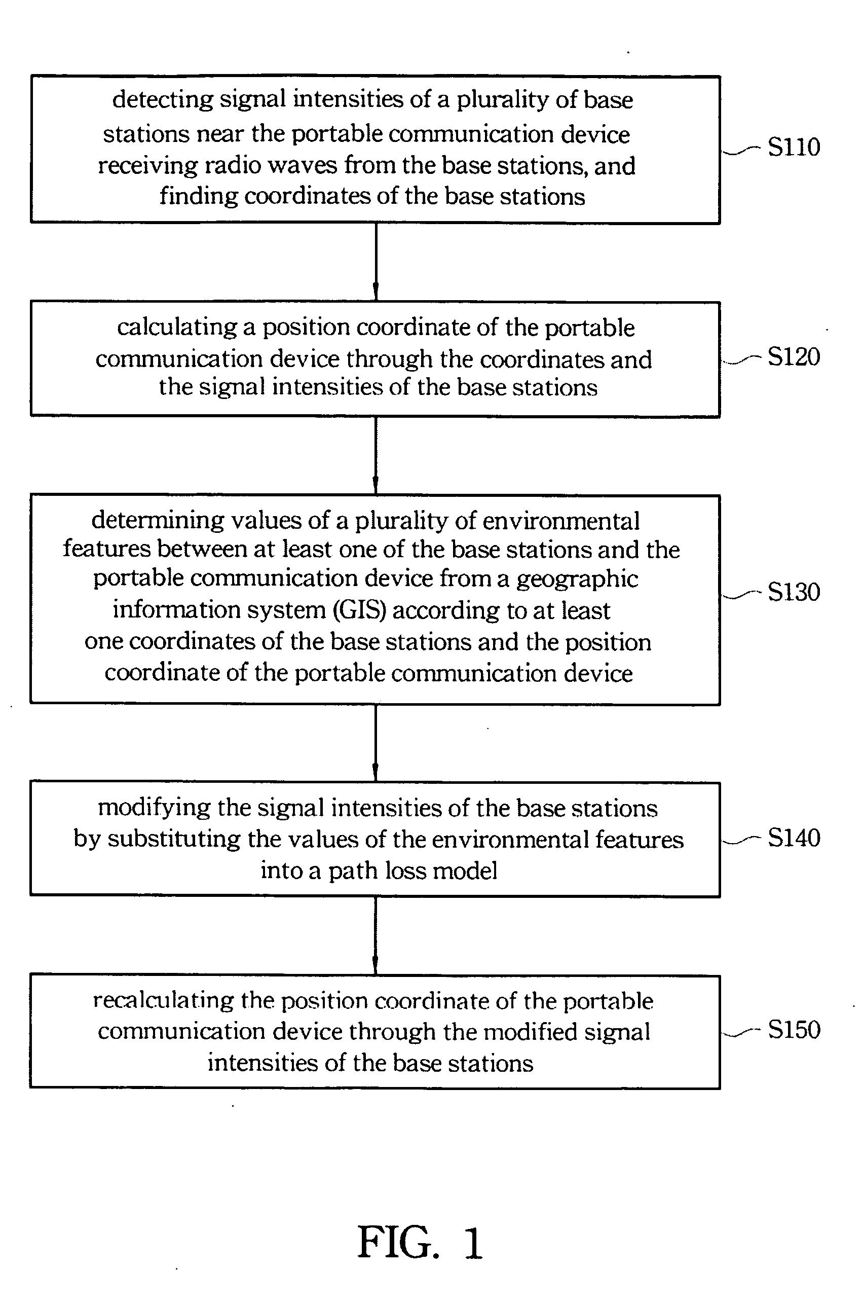
[0012]The present invention provides a method for positioning a portable communication device by modifying the signal intensities detected by the portable communication device through environmental features from a geographic information system (GIS) thereby increasing the positioning accuracy.
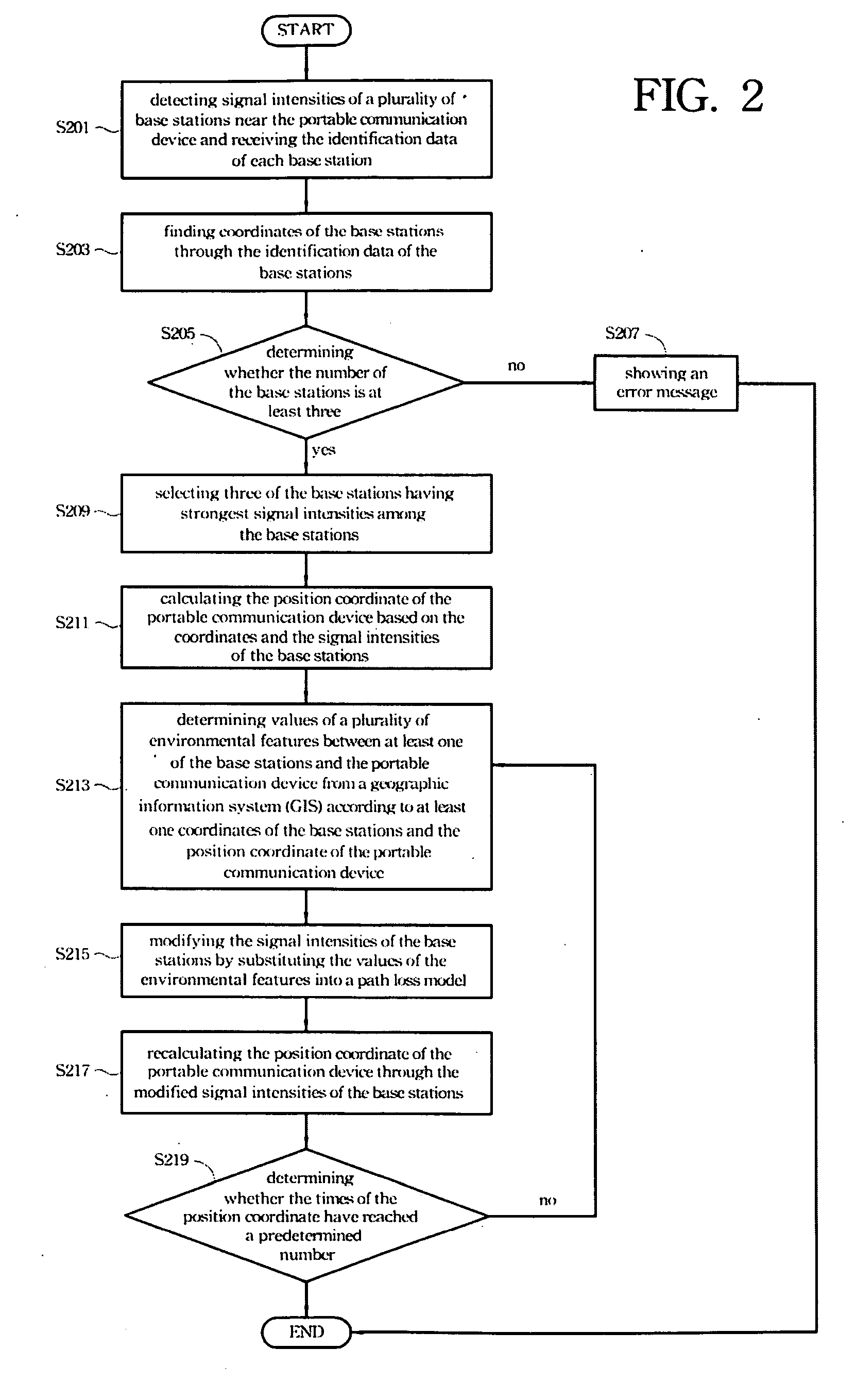
[0019]The present invention utilizes the environmental features between the base stations and the portable communication device from a geographic information system to modify the signal intensities. A modified position coordinate of the portable communication device is calculated through the signal intensities of the base stations. The modifying step is repeated to determine a more precise position coordinate thereby reducing error and enhancing the positioning accuracy.
[0028]The method of the present invention comprises classifying the regions where the base stations are located and calculates the statistical regional features of the regions in advance. During positioning of the portable communication device, the region feature of the region where the device is located at the present time may be determined as the region feature of the region where the closest base station is located wherein the closest base station may be determined through the signal intensities of the surrounding base stations. A more precise position coordinate is calculated through modification based on the regional feature thereby diminishing the error.

Problems solved by technology

However, the accuracy of conventional positioning algorithms is not acceptable for high-accuracy positioning applications wherein the error introduced by the propagation environment cannot be ignored.
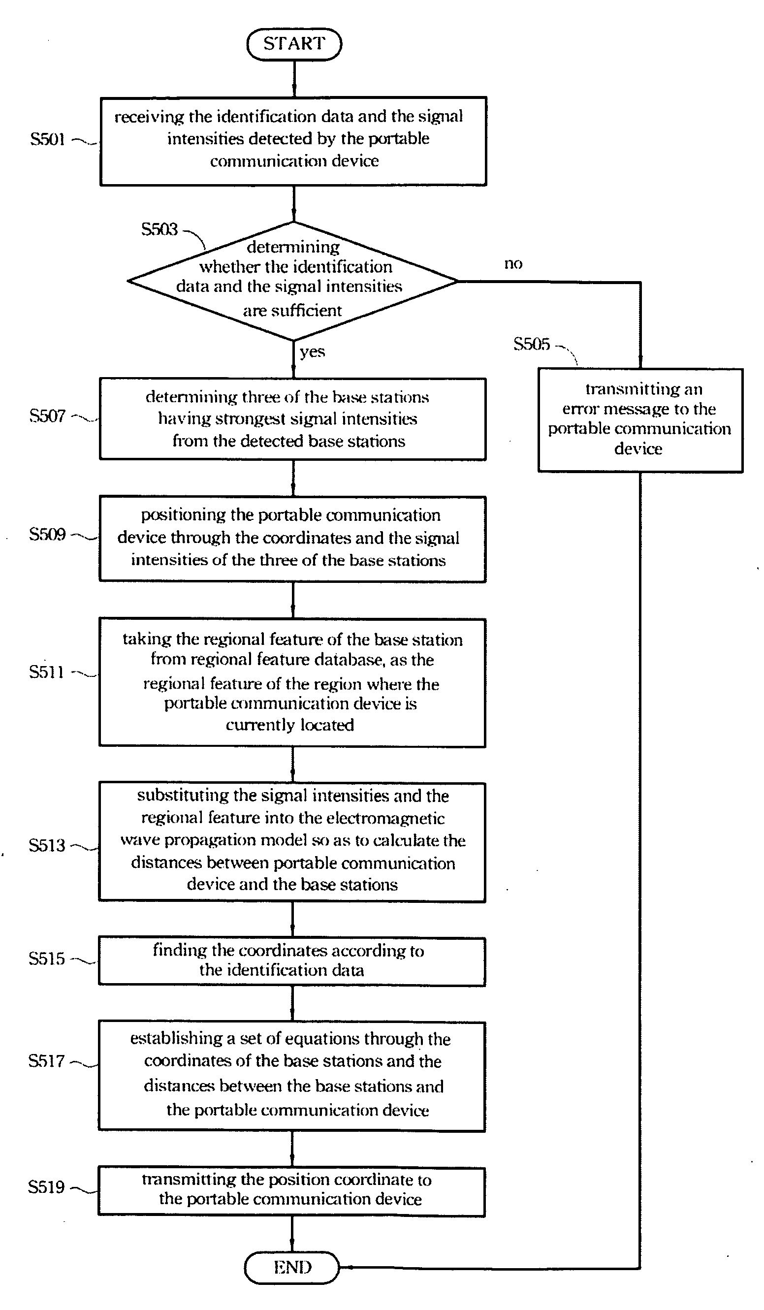
However, since the signal intensities may be affected by many factors such as the terrain features, the building intensity and the materials of the buildings around the portable device, the electromagnetic wave propagation model mentioned above cannot meet the actual condition.
If the smaller signal intensity detected by the portable device is substituted into the above equation, the calculated distance will be erroneous and different from the actual distance.
However, to meet theoretical research needs, conventional electromagnetic wave propagation models always consider so many factors that they have become too costly and too hard to implement in actual applications.
However, the real environment is not a Gaussian noise environment with uniform distribution.
It works well theoretically but costs too much to implement in actual applications.

Method used


Image

  • Method for positioning portable communication device
  • Method for positioning portable communication device
  • Method for positioning portable communication device

Examples


Embodiment Construction

[0035]Conventional positioning algorithms are typically performed without taking the environmental factors into consideration thereby increasing the positioning error. As a result, the present invention provides a method of raising the positioning accuracy by modifying the signal intensity of each of the base stations detected by the portable communication through the environmental features. The subject matter of the present invention will become apparent from the following description of embodiments.

[0036]FIG. 1 shows the flow chart of a method for positioning a portable communication device according to one embodiment of the present invention. First, in the step S110, after receiving a positioning request, the portable communication device will detect the signal intensities of the surrounding base stations receiving radio waves from the base stations, and find the coordinates (e.g., longitude and latitude) of each of the base stations. Specifically, the coordinates are determined ...


PUM


Abstract

A method for positioning a portable communication device is provided. First, the signal intensities of a plurality of base stations near the portable communication device receiving radio waves from the base stations are detected, and coordinates of the base stations are found in order to calculate a position coordinate of the portable communication device through the coordinates and the signal intensities of the base stations. Then, the values of a plurality of environmental features between at least one of the base stations and the portable communication device are obtained from a geographic information system (GIS) according to at least one coordinate of the base stations and the position coordinate of the portable communication device. After that, the signal intensities of the base stations are modified by substituting the values of the environmental features into a path loss model. Finally, the position coordinate of the portable communication device is recalculated according to the modified signal intensities of the base stations thereby enhancing the positioning accuracy substantially.

Description

FIELD OF THE INVENTION[0001]The present invention relates to a positioning method, particularly to a method for calculating the position coordinate of a portable communication device through modifying the signal intensities received by the portable communication device.BACKGROUND OF THE INVENTION[0002]Location based service (LBS) is typically utilized to identify a user's location information, e.g. longitude and latitude or geographic environment of local street, which may be provided to the user, the communication system provider (for fee calculation) or other organizations or people that need the location information. Because the method of positioning a portable device by itself has the advantages of low cost, high accuracy and being easily spread, LBS for portable device, which is widely applied in emergency rescue, car guidance, intelligent traffic management, team management and so forth, has become one of the most attention-getting techniques.[0003]In general, if the error int...

Claims


Application Information

Patent Timeline
IPC IPC(8): H04W4/02
CPCG01S5/14H04W64/00G01S11/06
Inventor ZENG, LEIZHANG, DA-WEI
Owner INVENTEC APPLIANCES CORP
Learn More