
Space Based Augmentation System Adapted for Improving the Accuracy and Reliability of Data Provided by a Satellite Navigation System and Associated Method

Active Publication Date: 2013-04-11
THALES SA
View PDF9 Cites 9 Cited by
  • Summary
  • Abstract
  • Description
  • Claims
  • Application Information

AI Technical Summary

Benefits of technology

The invention introduces a space-based system that can enhance the accuracy and reliability of data collected from satellite navigation systems. The system aims to improve the efficiency and reliability of navigation systems used in areas like aviation and marine applications.

Problems solved by technology

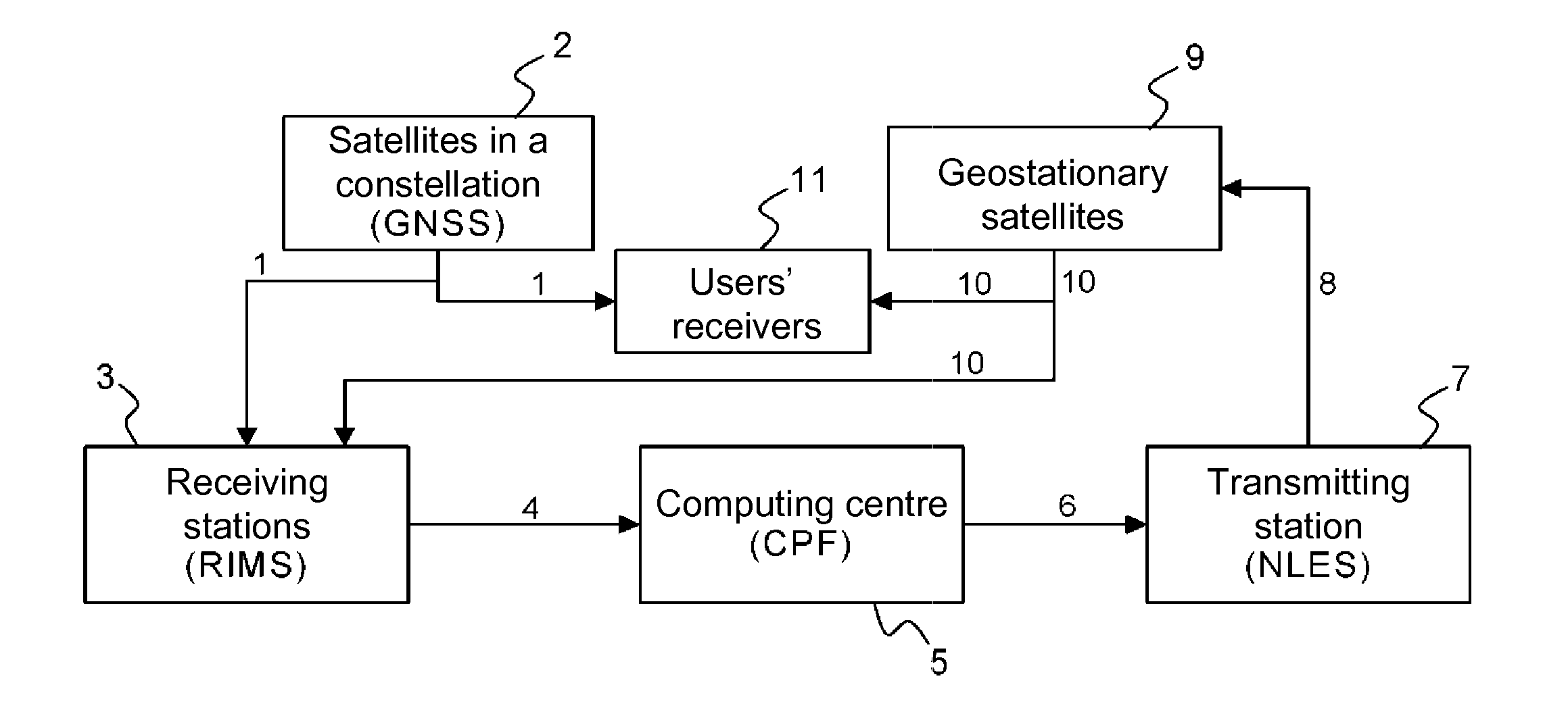
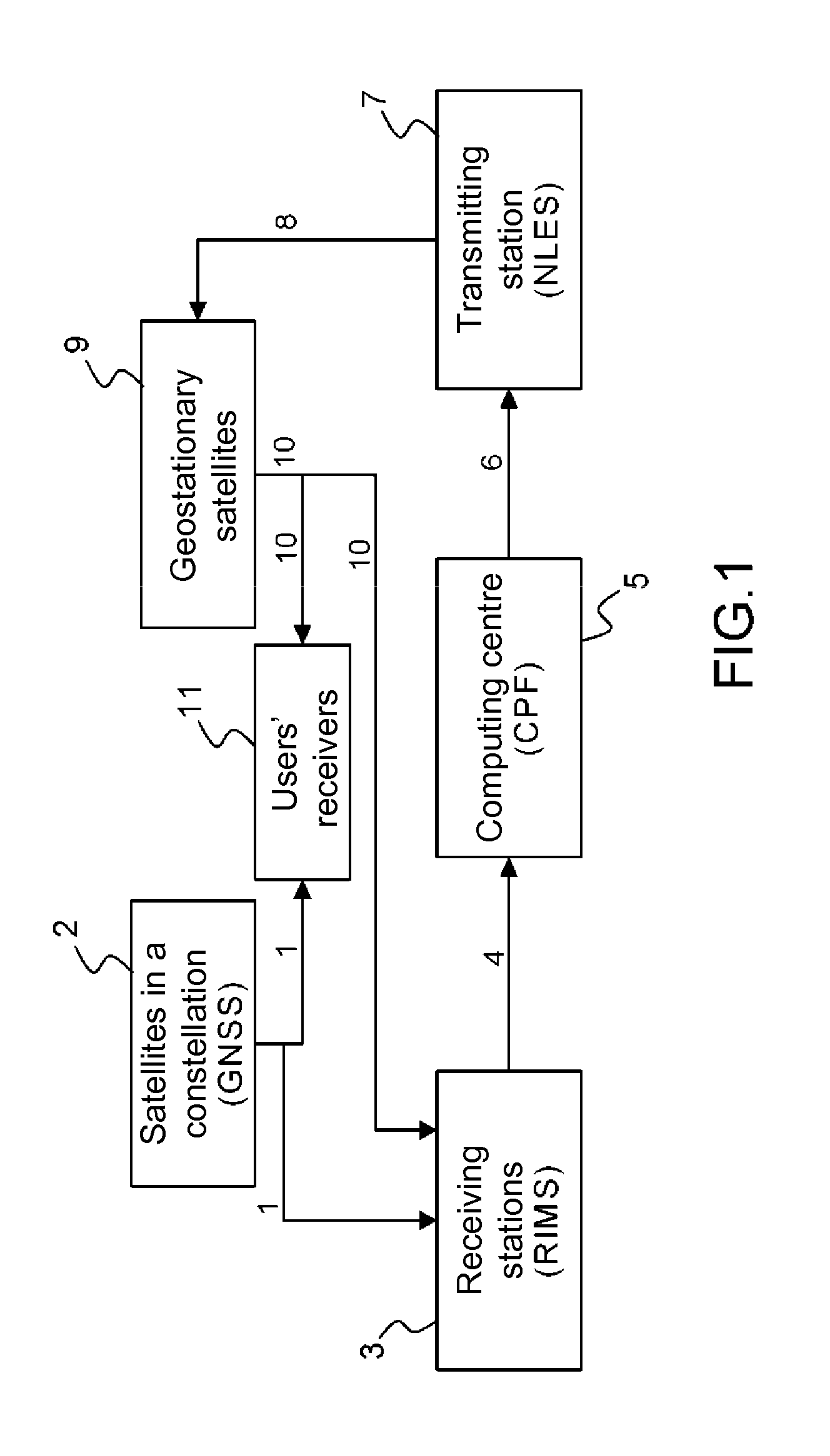
Such a basic embodiment does not provide the very short-term availability and continuity expected by users of such a system: a typical availability of the order of 99% and a loss of continuity probability better than 10−5 / h are characteristics of the expected performances for currently the most widespread use which is that of civil aviation.
Notably a failure in the main computing centre leads to the transmission of the NOF navigation message stream being interrupted and an immediate loss of continuity with an impact on availability.
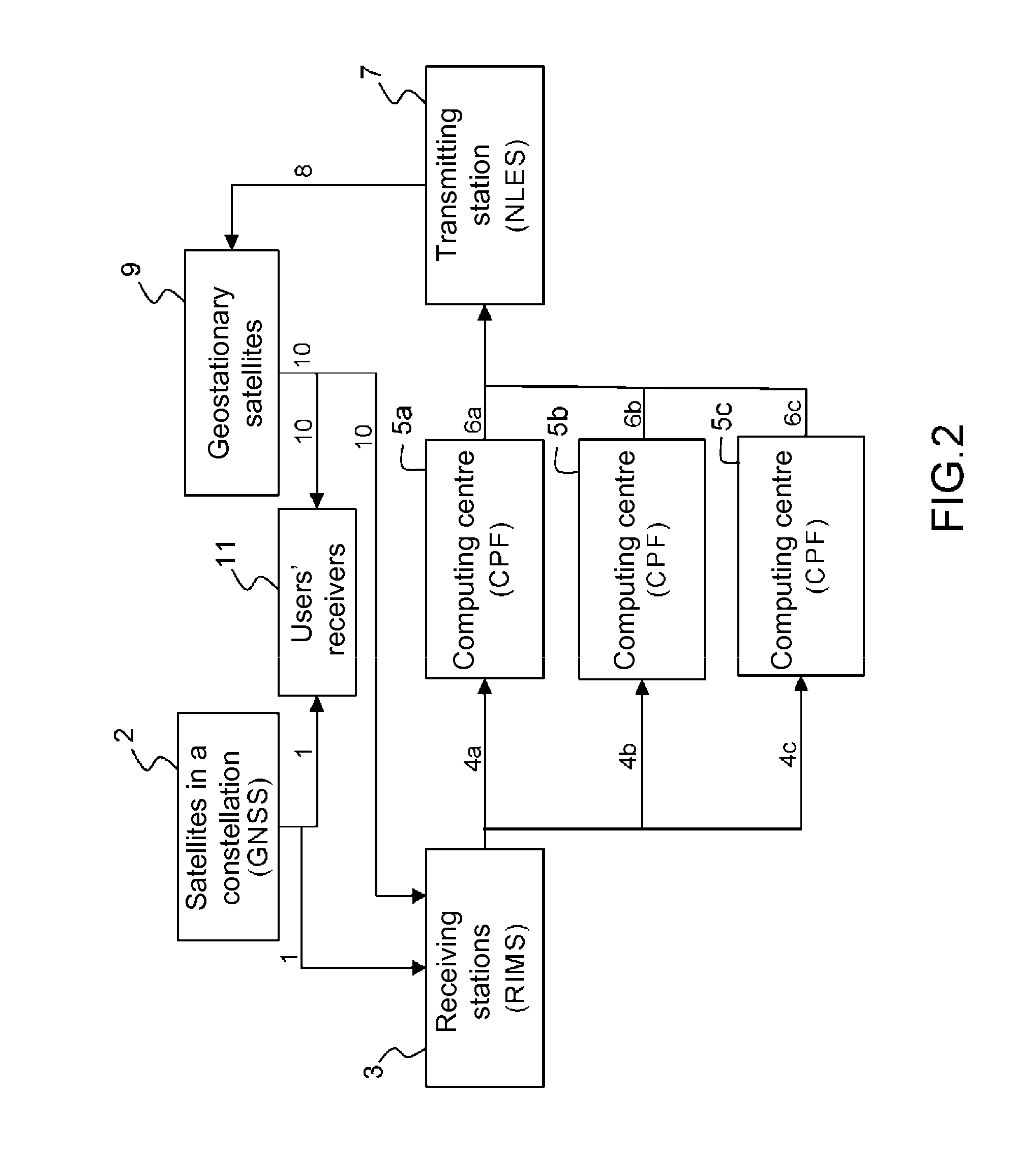
The EGNOS conventional solution in FIG. 2 presents a major drawback.
Because of the difference between these NOF navigation message sequences, when switching between the message sequence generated by a computing centre and that generated by the computing centre chosen by the NLES ground transmitting station for taking over, the problem arises of maintaining consistency between these message sequences.
These margins reduce the normal performance of the system outside periods of switching between computing centres.
Another drawback is associated with current systems seeking to minimize this very unfavourable effect.
This approach leads to operational difficulties, restarting a computing centre taking a significant time detrimental to the operation and efficient maintenance of the system.

Method used


Image

  • Space Based Augmentation System Adapted for Improving the Accuracy and Reliability of Data Provided by a Satellite Navigation System and Associated Method
  • Space Based Augmentation System Adapted for Improving the Accuracy and Reliability of Data Provided by a Satellite Navigation System and Associated Method
  • Space Based Augmentation System Adapted for Improving the Accuracy and Reliability of Data Provided by a Satellite Navigation System and Associated Method

Examples


Embodiment Construction

[0055]FIG. 3 shows a space based augmentation system adapted for improving the accuracy and reliability of the data provided by a satellite navigation system.

[0056]Several computing centres or CPFs, in this case four computing centres or CPFs 51a, 51b, 52a and 52b respectively receive data signals 4a and 4b in parallel from RIMS receiving stations and independently prepare their respective navigation message or NOF streams 61a, 61b, 62a and 62b which are each transmitted to the ground transmitting station or NLES 7. Computing centres 51a and 51b are in a first geographical area 51 and computer centres 52a and 52b are in a second geographical area 52. The ground transmitting station or NLES 7 selects one of these navigation message streams 8 from among message streams 61a, 61b, 62a and 62b and transmits it to users' receivers 11, in this case via the intermediary of geostationary satellites. In the event of failure of one of the computing centres 51a, 51b, 52, and 52b, the ground tra...


PUM


Abstract

A space-based augmentation system improving the accuracy and reliability of satellite navigation system data includes, each at least: a ground station transmitting data to satellites, a ground station receiving signals transmitted by a satellite and by a satellite equipped with transmitting / receiving means for transmitting data received from the ground transmitting station for a given geographical area; two ground computing centres, redundantly and respectively calculating navigation message streams and transmitting to the ground transmitting station navigation message streams and information representative of Quality of Service provided by the system, from signals transmitted by the ground receiving stations. The computing centres, ground receiving station and ground transmitting station are connected by a communication network. The ground transmitting station selects navigation message streams of a master computing centre according to information representative of respective Quality of Service of said computing centres, and said computing centres are synchronized on said master computing centre.

Description

CROSS-REFERENCE TO RELATED APPLICATION[0001]This application claims priority to foreign French patent application No. FR 1103057, filed on Oct. 7, 2011, the disclosure of which is incorporated by reference in its entirety.FIELD OF THE INVENTION[0002]The present invention relates to a space based augmentation system adapted for improving the accuracy and reliability of data provided by a satellite navigation system and associated method.BACKGROUND[0003]Space Based Augmentation Systems or SBAS are satellite radio navigation systems intended to supplement systems providing a basic satellite navigation system or Global Navigation Satellite Systems GNSS, such as the GPS, GALILEO or GLONASS systems for jointly providing superior performance in terms of location accuracy, availability and continuity of service and integrity of the information provided.[0004]These systems transmit an L-band signal on one or more (typically geostationary) satellites notably carrying a sequence of navigation ...

Claims


Application Information

Patent Timeline
IPC IPC(8): G01S19/07
CPCG01S19/02G01S19/46G01S19/07G01S19/074G01S5/0009G01S5/0081G01S19/05G01S19/08
Inventor CHARLOT, BERNARDBERTIN DE LA HAUTIERE, GONZAGUESTRILLES, SEBASTIEN
Owner THALES SA
Learn More