Solar timer using GPS technology

a solar timer and gps technology, applied in the field of solar timer using gps technology, can solve the problems of rapid performance of complex calculations, and achieve the effect of unstable inferior images

Active Publication Date: 2013-05-09
LONESTAR INVENTIONS LP
View PDF5 Cites 100 Cited by
  • Summary
  • Abstract
  • Description
  • Claims
  • Application Information

AI Technical Summary

Benefits of technology

[0044]When talking about the sunrise and sunset issues in the extreme latitudes one has to consider the atmospheric effects as well. Atmospheric pressure and temperature are included as input variables in the software package “OEA Astronomic and Navigational Computing Utilities” which takes care of the atmospheric refraction effects on the sun's elevation angle calculations up to a certain extent for normal conditions. Since the smart phone or computer tablet does not have the temperature and atmospheric pressure information, these variables are set to some reasonable values internally. In extreme latitudes there are more dominant effects caused by Mirage's which are not taken into consideration
[0045]There is a well known phenomenon called mirage which can change the apparent sunset and sunrise under certain conditions. In certain mirage conditions it has been recorded that when the evening sun has gone down for over 20 minutes it is still clearly visible [20]. These extreme conditions generally happen when there is very high temperature gradient, higher than 2° C. per meter and generally higher than 4-5° C. per meter over the ground. These conditions occur when there is strong heating at the ground level, and an “inferior” image is commonly generated as a result of this. It is called an inferior image because the resultant image seen is under the real object, in this case the sun. Inferior images are not stable. This type of inferior mirage is very often seen on highways, deserts, airport runways and it looks like water on the surface. Hot air rises and cooler air descends. In the process, the layers mix, and turbulence will cause distortion of the image. The image might look as if it is distorted, vibrating; it migh...

Problems solved by technology

Other challenges were to be able to rapidly perform these complex calculati...

Method used


Image

  • Solar timer using GPS technology
  • Solar timer using GPS technology
  • Solar timer using GPS technology

Examples


Embodiment Construction

[0089]The subject matter of embodiments of the present invention is described herein with specificity to meet statutory requirements, but this description is not necessarily intended to limit the scope of the claims. The claimed subject matter may be embodied in other ways, may include different elements or steps, and may be used in conjunction with other existing or future technologies. This description should not be interpreted as implying any particular order or arrangement among or between various steps or elements except when the order of individual steps or arrangement of elements is explicitly described.

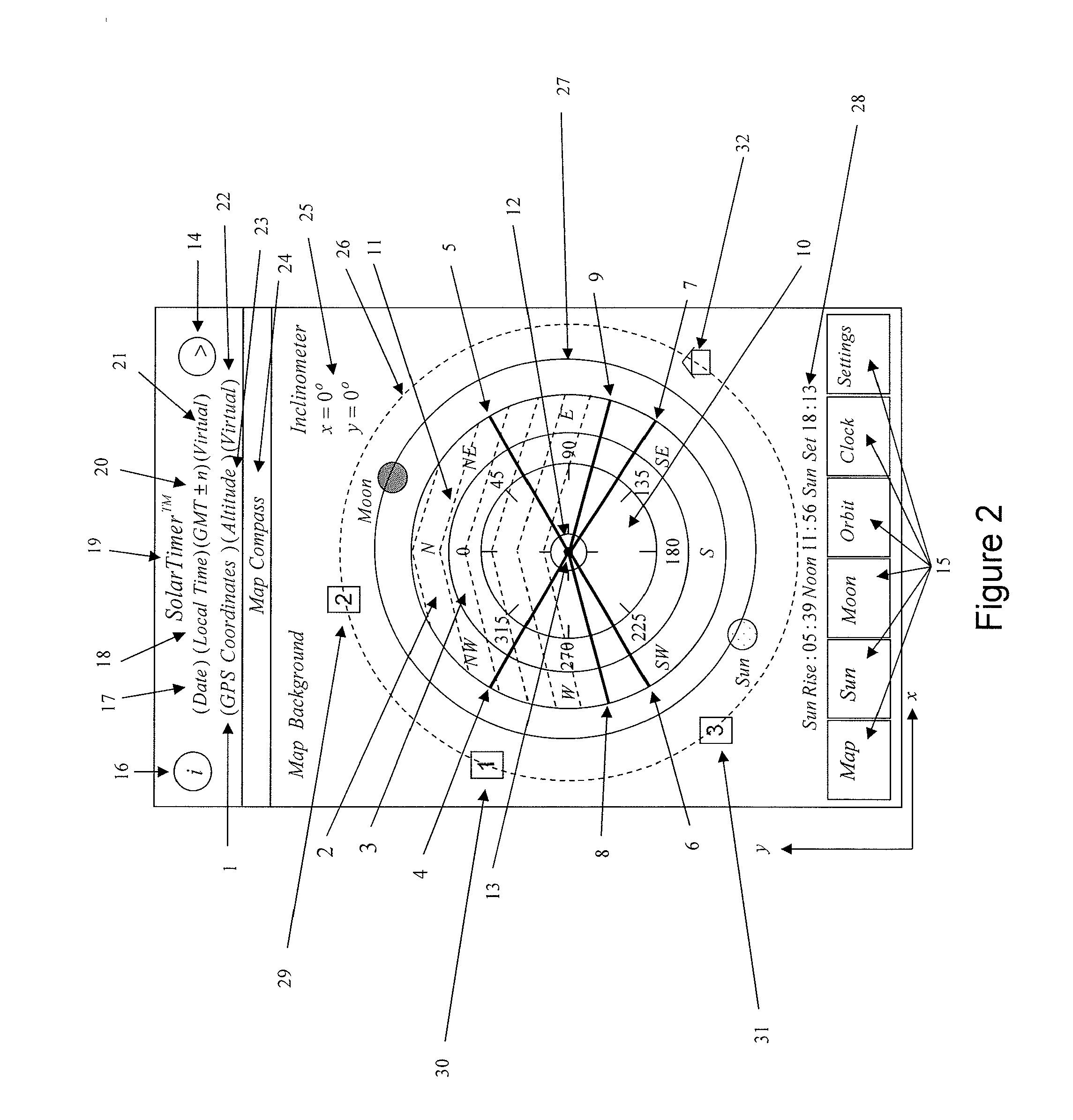
[0090]The basis of the present invention is a GPS compass incorporated into a device with a display, a processor, storage memory and manual input as well as inputs from sensors, and in particular in a portable device such as a smart phone or tablet computer equipped with a conventional GPS receiver that depicts positions of interest in time relationship of terrestrial and cele...


PUM


Abstract

In a GPS-equipped device such as a smart phone or a tablet computer with a compatible operating system, a useful dynamic display of directional and timing information is provided based on GPS data obtained through conventional means processed according to computational modules or applications stored on the device. These displays include a solar timer, a compass dial and other date, time and location-based information. Underlying the displayable information is a database of information that is processed with input from an accurate compass employing a calculated reference line based on two time-separated GPS readings and a direction parameter.

Description

CROSS-REFERENCES TO RELATED APPLICATIONS[0001]The present application claims benefit under 35 USC 119(e) of U.S. provisional Application No. 61 / 557,576, filed on Nov. 9, 2011, entitled “Solar Timer Using GPS Technology,” the content of which is incorporated herein by reference in its entirety.STATEMENT AS TO RIGHTS TO INVENTIONS MADE UNDER FEDERALLY SPONSORED RESEARCH AND DEVELOPMENT[0002]NOT APPLICABLEREFERENCE TO A “SEQUENCE LISTING,” A TABLE, OR A COMPUTER PROGRAM LISTING APPENDIX SUBMITTED ON A COMPACT DISK[0003]NOT APPLICABLEBACKGROUND OF THE INVENTION[0004]This invention relates to uses of GPS data applied to direction and timing, and in particular to a presentation or display of such information.[0005]As used herein a solar timer is a term referring to a package of functions incorporated in an application program comprising the present invention. It may be used in the form of a trademark SolarTimer to refer to a consumer entertainment tool made up of the package of these func...

Claims


Application Information

Patent Timeline
IPC IPC(8): G04G9/00G06F19/00G16Z99/00
CPCG04G9/00G06F19/00G04G9/0064G16Z99/00
Inventor AKCASU, OSMAN ERSEDAKCAY, IBRAHIM
Owner LONESTAR INVENTIONS LP
Why Eureka
Try Eureka