Mobile phone network management systems

a mobile phone network and management system technology, applied in network planning, network data management, electrical equipment, etc., can solve problems such as difficulty in troubleshooting networks, insufficient technical data for solving real-world problems, and increase in the number and complexity of different devices connecting to a mobile network, so as to facilitate rapid access to spatial data, improve the coverage of said ran, and improve the effect of spatial data

Active Publication Date: 2013-06-20
ACTIX
View PDF3 Cites 56 Cited by
  • Summary
  • Abstract
  • Description
  • Claims
  • Application Information

AI Technical Summary

Benefits of technology

[0009]In embodiments a geospatial element is a data object with spatial properties, for example a polygon or grid rectangle or square defined by its size and location. The skilled person will appreciate that this data element is distinct from its representation in a 2D or 3D visualisation—in embodiments any of a range of different visualisation techniques may be employed. Further, in embodiments a geospatial grid element may have a position in a spatial hierarchy and may, for example, represent an aggregation of other elements defining smaller spatial extents. In embodiments a geospatial element may represent millions of data points aggregated by space and / or time (as described further later). Thus preferably a hierarchical data storage approach is employed to avoid rounding errors data, storing data in terms of re-aggregatable (intermediate) statistics. These data may comprise, for example, sum and count values from which an average value may be derived in addition to, or instead of, the average value itself. This facilitates generating aggregate statistics, as well as drilling down to the underlying data.
[0012]In preferred embodiments the querying system comprises a user interface for defining a query for the spatial data integration system. Preferably this incorporates a visual query tool which enables the user to define a spatial query by identifying a region of the geospatial map. This is then converted into a spatial query to apply to the spatial data integration system. In embodiments, however, the user interface also enables a user to define a query in terms of one or more logical expressions or rules to be applied to the RAN performance and / or subscriber account data. Preferably the querying system further enables a user to define a “second tier” query, for example in terms of one or more expressions / rules defining one or more further filter parameters to be applied to the output from querying the region defined by the original spatial query. This enables a user to more easily determine, say, the most important issues in a particular, selected spatial region.
[0013]Broadly speaking, therefore, the spatial query system identifies in detail a set of elements and attributes which can then be extracted from the spatial data integration system and correlated to identify spatial regions where it is desirable to address network performance problems. Some preferred implementations of the system further include a user-adjustable filter employing a user-definable expression, and having a variable parameter in order to apply a variable image effect to the correlation displayed on the shared geospatial map. For example a user control such as a slider may be provided to enable adjustment of a degree of transparency of one attribute. This facilitates identifying a correlation between attributes displayed on the map.
[0023]In a related aspect the invention provides a computer-implemented method of improving coverage of the RAN of a mobile phone networks, the method comprising: inputting subscriber data for subscriber accounts of a plurality of present / past subscribers; inputting geolocated RAN performance data defining a map of one or more quality of service parameters of said RAN over a region of coverage of said RAN of said mobile phone network; combining said geolocated RAN performance data defining said map of said one or more quality of service parameters with said subscriber data; and outputting data predicting problem areas of said coverage of said RAN from said combining, for improving coverage of said RAN in said predicted problem areas.
[0027]In some preferred embodiments the subscriber data includes data identifying a value of a subscriber account, albeit without necessarily importing detailed billing information. The method may then further include selecting a predicted problem area for improving coverage in response to values of subscriber accounts in the predicted problem areas. More particularly the method may comprise indentifying the location of a femtocell to add to the RAN to serve one or more individual identified high value subscriber accounts in a particularly location to address a predicted problem for these accounts. Thus the improved coverage of the RAN may able targeted at specific individual subscribers or subscriber accounts (noting that a subscriber account may be a business account associated with more than one user). Thus technical resources to improve the RAN coverage may be directed efficiently to where they can best be utilised.

Problems solved by technology

There has been an exponential rise in mobile data usage, but there has also been a rise in the number and complexity of the different devices connecting to a mobile network.
More generally, troubleshooting networks has become more difficult, and existing technical data can sometimes prove insufficient for solving real-world problems.

Method used


Image

  • Mobile phone network management systems
  • Mobile phone network management systems
  • Mobile phone network management systems

Examples


Embodiment Construction

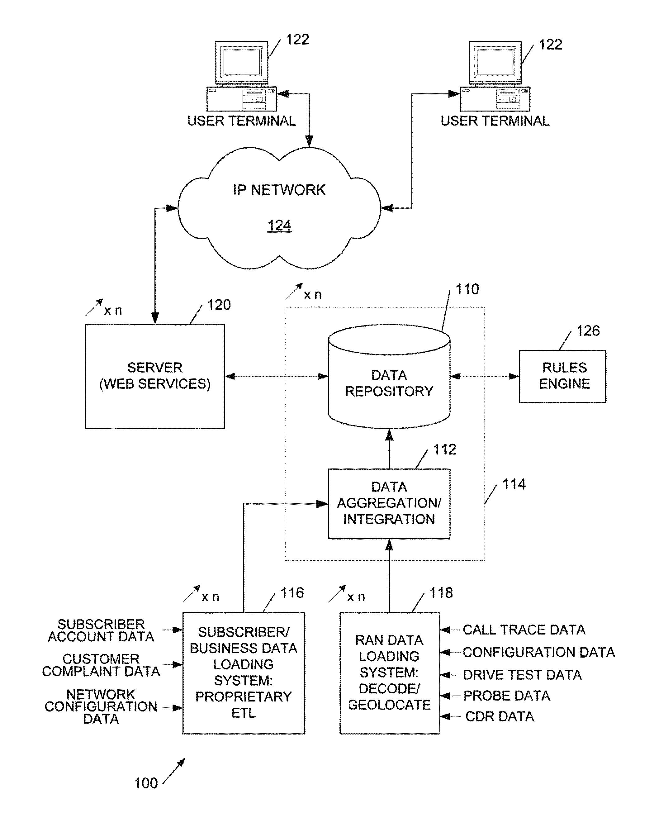
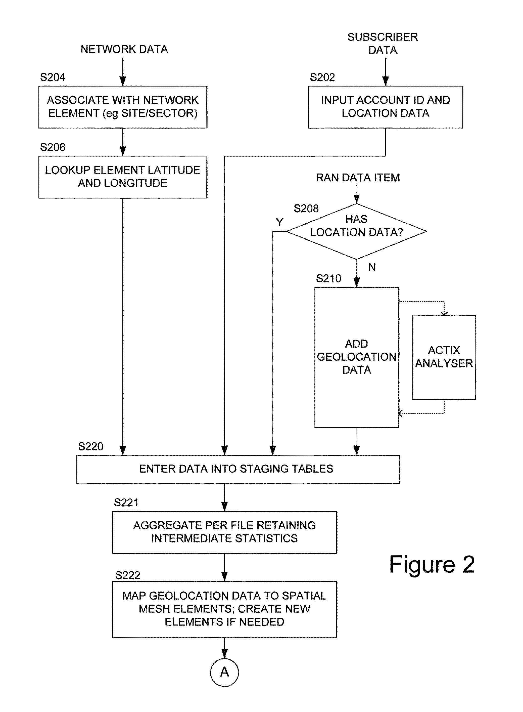
[0046]Broadly speaking the systems and methods we will describe employ a spatial database defining a spatial grid to aggregate geolocated subscriber data, for example specifying a latitude / longitude location of a subscriber with radio access network (RAN) performance data from a wide range of sources. In general the geolocation is not precise and thus many, potentially millions, of points are aggregated into grid squares and, in embodiments, smoothed over neighbouring squares. The data is also dimensioned by time and by mobile device / device type, and a pivot-table type approach enables aggregation by selected dimensions of the data, as well as drill-down into the underlying data, avoiding rounding errors by storing sums and counts. The grid information is visualisable to facilitate user identification of priority areas for optimisation, but the data may be employed for automatically scheduling radioengineering tasks, either for service engineers or for direct implementation by a mob...


PUM


Abstract

A system and methods for maintaining or optimising a mobile phone network by spatially correlating geolocated radio access network (RAN) performance measurement data and geolocated subscriber account data, which in embodiments provides additional technical information on the RAN performance. These data are integrated in a spatial data structure and provided with a spatial querying and data correlation system for identifying, and addressing problem areas of the RAN.

Description

RELATED APPLICATION[0001]This application is a continuation application of U.S. patent application Ser. No. 13 / 352,080, filed on Jan. 17, 2012, which application claims the benefit of priority under 35 U.S.C. Section 119 to United Kingdom Patent Application Serial No. 1121466.5, filed on Dec. 14, 2011, which applications are incorporated herein by reference in their entirety.FIELD OF THE INVENTION[0002]This invention relates to systems, methods and computer program code for maintaining / optimising a mobile phone network.BACKGROUND TO THE INVENTION[0003]We have previously described techniques for collecting and visualising mobile phone network data (our U.S. Pat. No. 7,830,812, ‘Viewpoint’, hereby incorporated by reference). More particularly this describes techniques for aggregating network monitoring data into higher level statistics for the automatic reporting and geographical visualisation of performance engineering information (KPIs—Key Performance Indicators) on maps, in such a ...

Claims


Application Information

Patent Timeline
Patent Type & Authority Applications(United States)
IPC IPC(8): H04W64/00
CPCH04W24/08H04W64/00H04W8/18H04W24/02H04L43/045H04W16/22H04L43/04H04W16/18
Inventor KATELEY, RICHARDHAINES, CHRISHARRIS, RICHARDHUNT, MARTIN
Owner ACTIX
Why Eureka
Try Eureka