Mobile phone network management systems

Active Publication Date: 2013-01-29
ACTIX
View PDF10 Cites 44 Cited by
  • Summary
  • Abstract
  • Description
  • Claims
  • Application Information

AI Technical Summary

Benefits of technology

[0022]In embodiments, to facilitate rapid access to the spatial data in the spatial data integration system a dimension of one attribute may be explicitly labelled as another attribute. Further, some attributes may be calculated on the fly, and are thus ‘virtual’ in the sense that there is no explicit row in the data structure corresponding to the attribute. Preferably a spatial hierarchy of geospatial elements is also defined. For additional efficiency, in some preferred embodiments the spatial data integration system only generates a data entry for a geospatial element when data is received relating to that element, and thus the spatial coverage is gradually built up in accordance with the data provided to the system rather than initially providing geospatial elements for ev

Problems solved by technology

There has been an exponential rise in mobile data usage, but there has also been a rise in the number and complexity of the different devices connecting to a mobile ne

Method used


Image

  • Mobile phone network management systems
  • Mobile phone network management systems
  • Mobile phone network management systems

Examples


Embodiment Construction

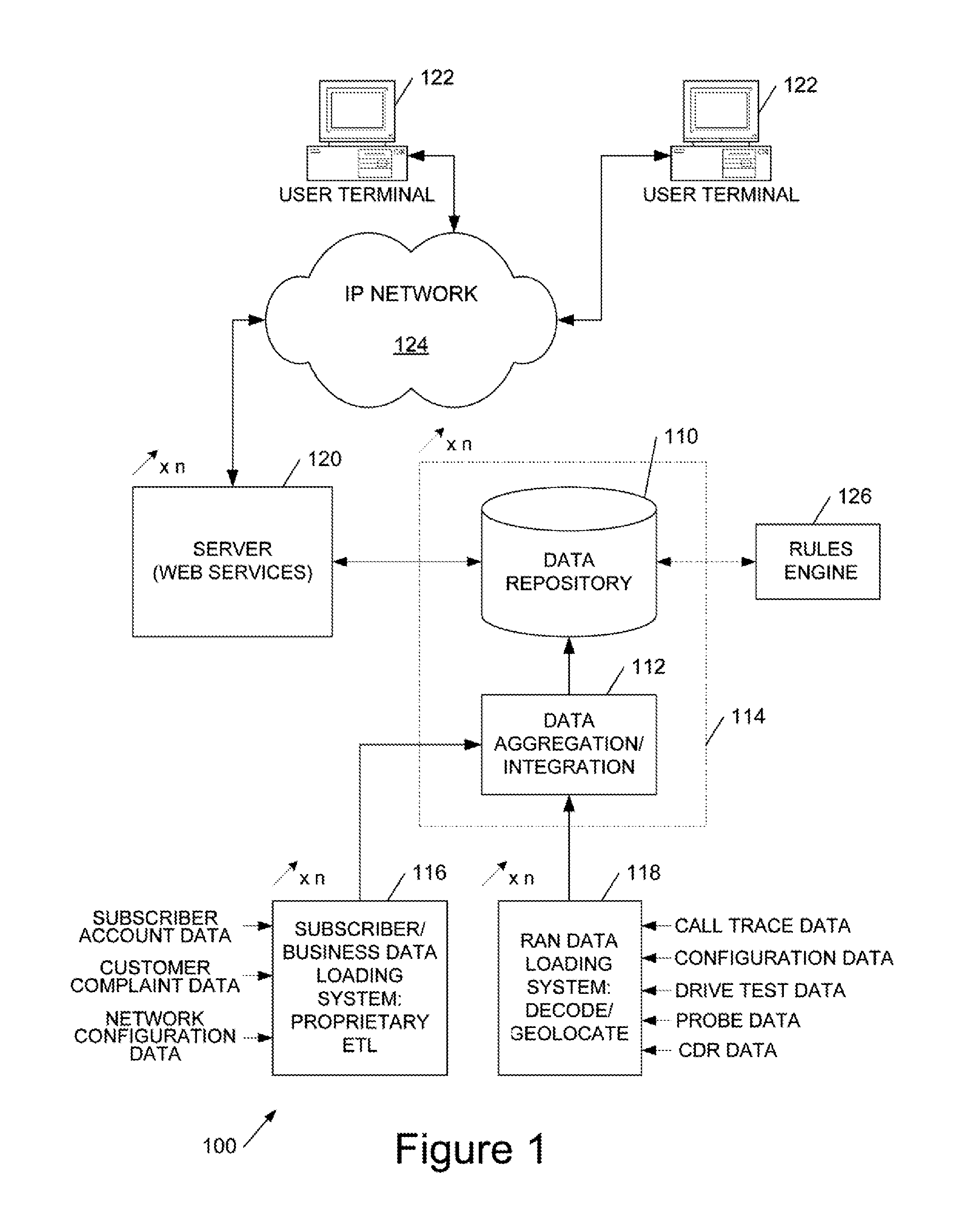
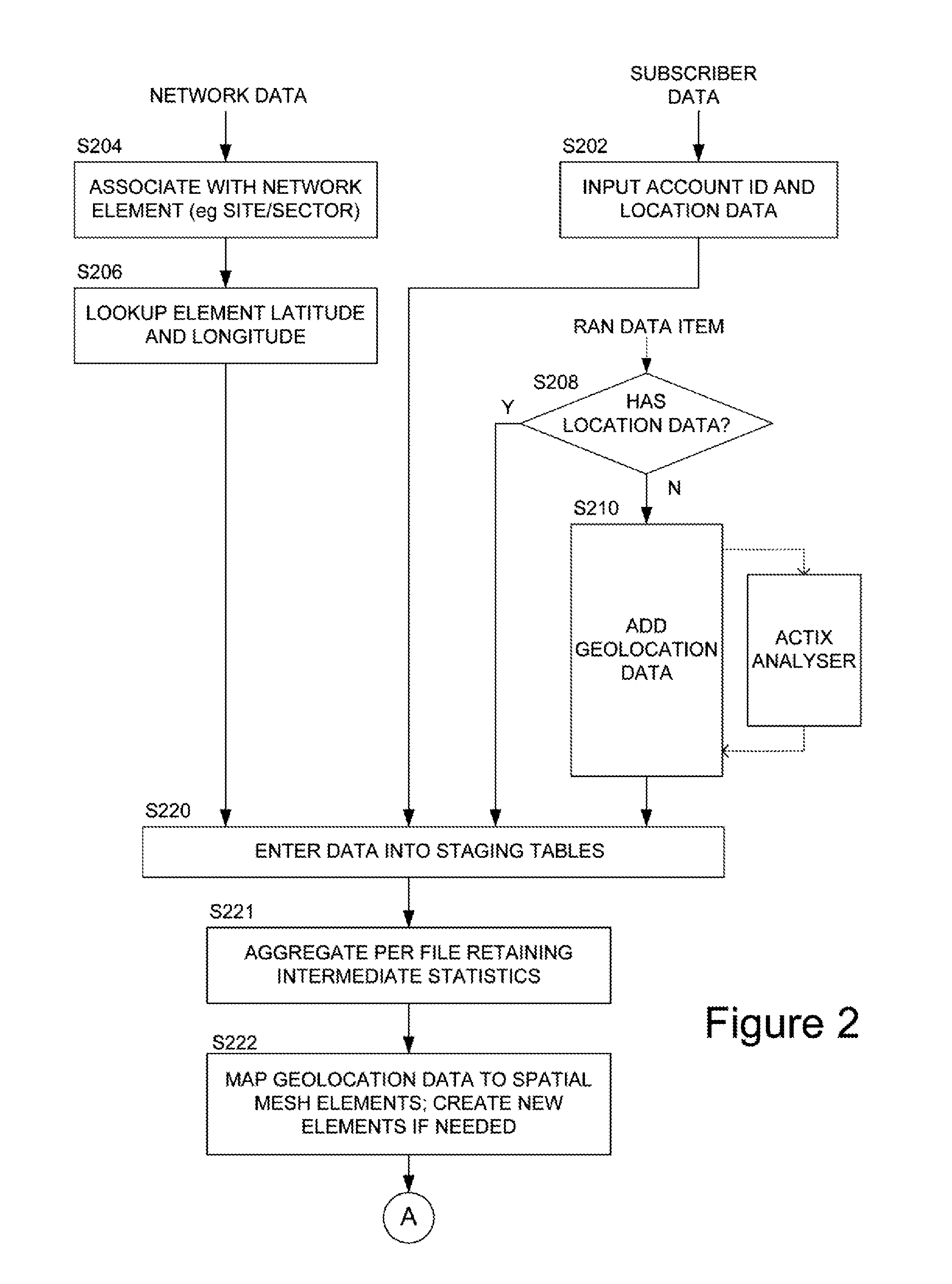
[0046]Broadly speaking the systems and methods we will describe employ a spatial database defining a spatial grid to aggregate geolocated subscriber data, for example specifying a latitude / longitude location of a subscriber with radio access network (RAN) performance data from a wide range of sources. In general the geolocation is not precise and thus many, potentially millions, of points are aggregated into grid squares and, in embodiments, smoothed over neighbouring squares. The data is also dimensioned by time and by mobile device / device type, and a pivot-table type approach enables aggregation by selected dimensions of the data, as well as drill-down into the underlying data, avoiding rounding errors by storing sums and counts. The grid information is visualisable to facilitate user identification of priority areas for optimisation, but the data may be employed for automatically scheduling radioengineering tasks, either for service engineers or for direct implementation by a mob...


PUM


Abstract

A system and methods for maintaining or optimising a mobile phone network by spatially correlating geolocated radio access network (RAN) performance measurement data and geolocated subscriber account data, which in embodiments provides additional technical information on the RAN performance. These data are integrated in a spatial data structure and provided with a spatial querying and data correlation system for identifying, and addressing problem areas of the RAN.

Description

RELATED APPLICATION[0001]This application claims the benefit of priority under 35 U.S.C. Section 119 to United Kingdom Patent Application Serial No. 1121466.5, filed on Dec. 14, 2011, which application is incorporated herein by reference in its entirety.FIELD OF THE INVENTION[0002]This invention relates to systems, methods and computer program code for maintaining / optimising a mobile phone network.BACKGROUND TO THE INVENTION[0003]We have previously described techniques for collecting and visualising mobile phone network data (our U.S. Pat. No. 7,830,812, ‘Viewpoint’, hereby incorporated by reference). More particularly this describes techniques for aggregating network monitoring data into higher level statistics for the automatic reporting and geographical visualisation of performance engineering information (KPIs—Key Performance Indicators) on maps, in such a way as to enable drilling down to low level data, in embodiments down to individual messages. We have also described related...

Claims


Application Information

Patent Timeline
IPC IPC(8): H04W24/00
CPCH04W24/08H04W64/00H04W8/18H04W24/02H04L43/045H04W16/22H04L43/04H04W16/18
Inventor KATELEY, RICHARDHAINES, CHRISHARRIS, RICHARDHUNT, MARTIN
Owner ACTIX
Why Eureka
Try Eureka