Geocoding points of interest and service route delivery and audit field performance and sales method and apparatus

a technology of service route and applied in the field of geocoding point of interest and service route delivery, and audit field performance and sales method and apparatus, to achieve the effect of improving the distribution process

Inactive Publication Date: 2013-12-19
MAPAS INTELIGENTES
View PDF20 Cites 35 Cited by
  • Summary
  • Abstract
  • Description
  • Claims
  • Application Information

AI Technical Summary

Benefits of technology

[0007]The invention comprises a computer method that updates and corrects customer delivery route point of interest data bases using coordinates, allowing sales representatives to perform real time field audits to design and correct allocations of volume and product mix for diverse clientele. It further improves the di

Problems solved by technology

These geocoding systems emphasize logistics improvements, business location service, fleet management, routing design, but none encompasses an integrated cloud service computer method to centrally audit and control on site sales,

Method used


Image

  • Geocoding points of interest and service route delivery and audit field performance and sales method and apparatus
  • Geocoding points of interest and service route delivery and audit field performance and sales method and apparatus
  • Geocoding points of interest and service route delivery and audit field performance and sales method and apparatus

Examples


Embodiment Construction

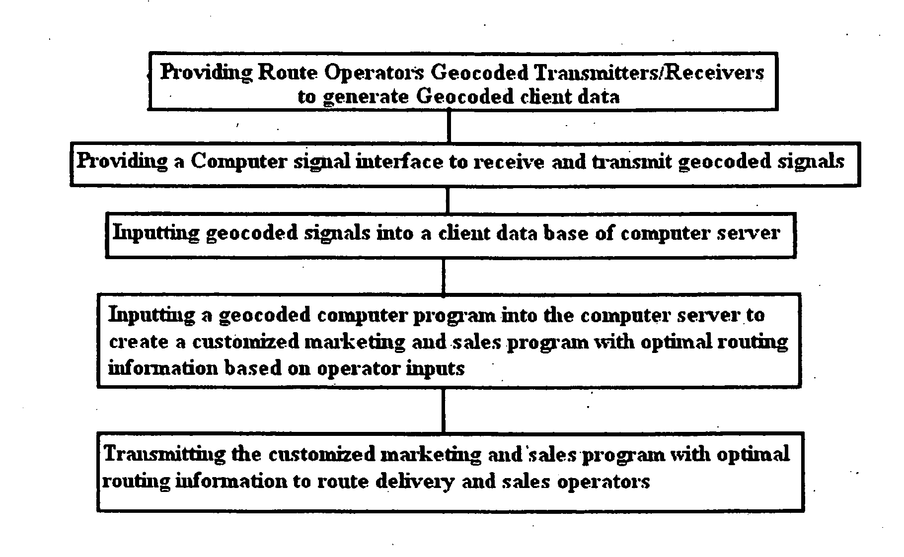
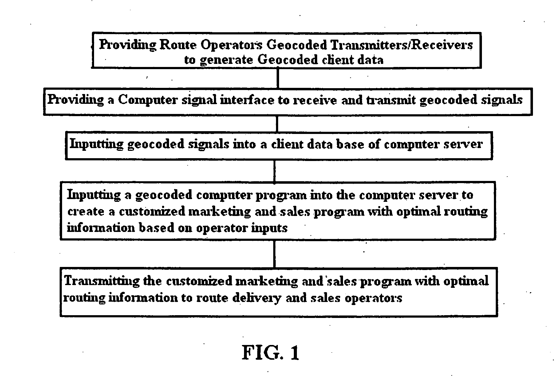
[0045]FIG. 1 is a flow chart of one embodiment of the method of the invention showing a typical sequencing. As shown in FIG. 1, the method provides route operators geocoded transmitters / receivers to generate and input geocoded client data. This geocoded client data is transmitted via a computer signal interface, such as blue tooth, WIFI, GPRS, mobile phone networks, etc. to the client data base of a computer server. A geocoded computer program (not shown) is inputted into the computer server to create a customized marketing and sales program with optimal routing information based on the operator inputs in the client data base. The customized marketing and sales program with optimal routing information is then transmitted via a web cloud to the route delivery and sales operators.

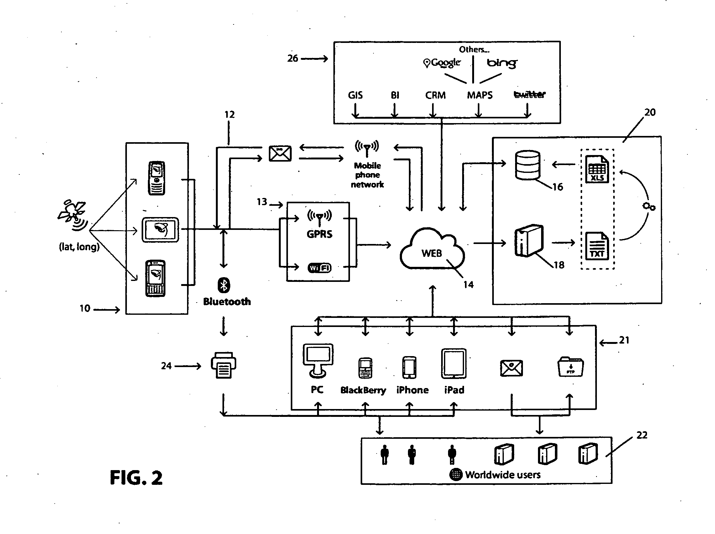
[0046]FIG. 2 is a schematic layout of a typical embodiment of the apparatus to implement the method of the invention. A plurality of computer interactive data transmitters and GPS receivers 10 are provided to...


PUM


Abstract

A computer guided geocoded route service sales and deliveries method and apparatus optimizing geomarketing, financial and sales, and improved logistics along delivery routes using operator transmitters/receivers inputs of route information in one mode, which receive and display to the operator in another mode computer generated pricing, sales, financial and marketing information, optimal routes, and other related information concerning each customer and distribution point of interest along a route, which are displayed or not, to the operator as he/she reaches the particular latitude and longitude of a point of interest enforcing the operator to act as it is indicated.

Description

BACKGROUND OF THE INVENTION[0001]1. Field[0002]This invention deals with service route delivery optimization methods. In particular, it relates to a cloud computer method that improves market definition and segmentation methods, integrates such results for route delivery and optimization utilizing “Geomatics,” also known as geospatial technology or geomatics engineering, (the discipline of gathering, storing, processing, and delivering geographic information, or spatially referenced information) in several business processes, such as auditing the delivery, sale and payment processes creating the basis for cash less and electronic cash transfers procedures, geocoding, routing, tracking, advertising and promotional efforts, safety and security concerns, as well as setting the fundamental capabilities for cash collection, credit assignment, and electronic cash transfers.[0003]2. State of the Art[0004]Various geocoding methods and apparatus are known. For example, Santoro et al., U.S. P...

Claims


Application Information

Patent Timeline
IPC IPC(8): G06Q10/04
CPCG06Q10/047G06Q10/08G06Q30/02
Inventor BARANDA, ALFREDO VELAZQUEZ
Owner MAPAS INTELIGENTES
Why Eureka
Try Eureka