
Apparatus and method for processing metadata in augmented reality system

a technology of augmented reality and metadata, applied in the field of data processing techniques, can solve the problems of high production cost, incongruity between an actual object and an image displayed on a screen, incongruity between an actual environment and a 3d image on a screen, etc., and achieve the effect of simplifying and standardized structur

Inactive Publication Date: 2015-04-30
ELECTRONICS & TELECOMM RES INST
View PDF0 Cites 18 Cited by
  • Summary
  • Abstract
  • Description
  • Claims
  • Application Information

AI Technical Summary

Benefits of technology

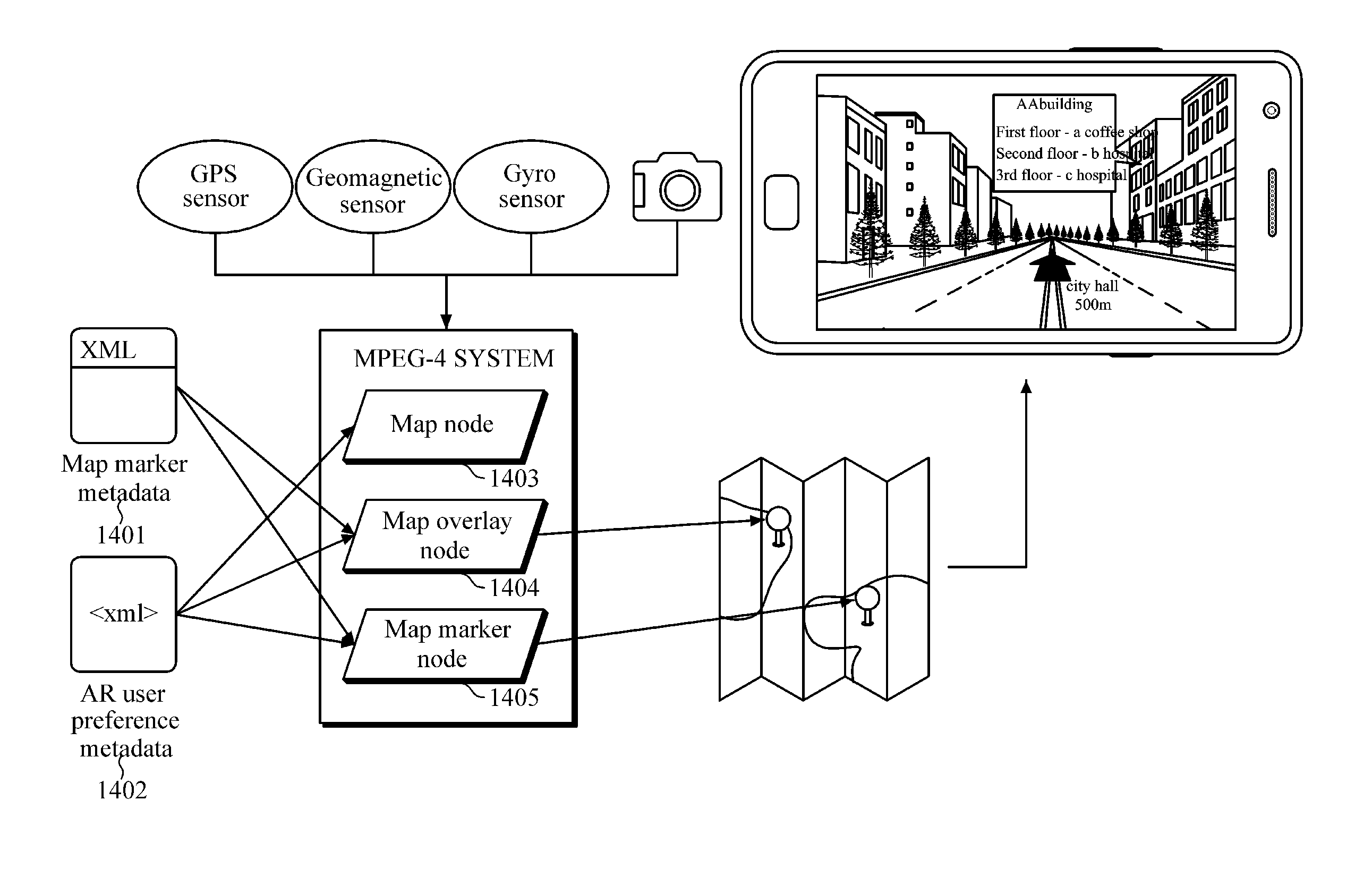
The patent describes an apparatus and method for processing metadata in an augmented reality navigation system. The system uses map information and user preference information to provide customized information to users. The system includes a map node for setting a virtual map, a map overlay node for setting a layer in which augmented reality objects are to be overlaid on a map, a map marker node for setting the position of an augmented reality object on the map, a point of interest node for setting information on a point of interest, and a controller for loading the virtual map, layer, map marker, and point of interest. The system also includes a map marker metadata storage and a user preference metadata storage. The technical effects of the patent include providing customized information to users and simplifying the structure of the system.

Problems solved by technology

However, such method has drawbacks in that when an electronic map is output to a screen in real time, an accurate field of view may not be obtained in an actual moving direction of a vehicle, with unnecessary information also being displayed, and image data may not be timely loaded according to a moving speed, thereby causing incongruity between an actual object and an image displayed on a screen, as well as inconvenience due to a difference between an actual 3D environment and a 2D plane map.
However, the 3D electronic map also has problems in that it is difficult to produce and modify a 3D map, which has high production costs, and greater map data space is required than a 2D electronic map, thereby requiring a greater deal of information processing in a location updating process, and easily causing incongruity between an actual environment and a 3D image on a screen.
However, the MPEG-ARAF fails to define a standard for points of interest.
However, as points of interest are not represented by a standard notation method, there is a problem in that map instance information, which is continuously updated, is difficult to manage in a single application.
Further, different notation methods make it impossible to share map instance information in applications that have similar functions, thereby resulting in inefficient use of information.
However, even a metadata structure is not defined that includes user preference information for providing a customized augmented reality navigation system, such that users are required to set an augmented reality system according to their preferences every time they operate their own system.

Method used


Image

  • Apparatus and method for processing metadata in augmented reality system
  • Apparatus and method for processing metadata in augmented reality system
  • Apparatus and method for processing metadata in augmented reality system

Examples


Embodiment Construction

[0050]The following description is provided to assist the reader in gaining a comprehensive understanding of the methods, apparatuses, and / or systems described herein. Accordingly, various changes, modifications, and equivalents of the methods, apparatuses, and / or systems described herein will be suggested to those of ordinary skill in the art. Also, descriptions of well-known functions and constructions may be omitted for increased clarity and conciseness.

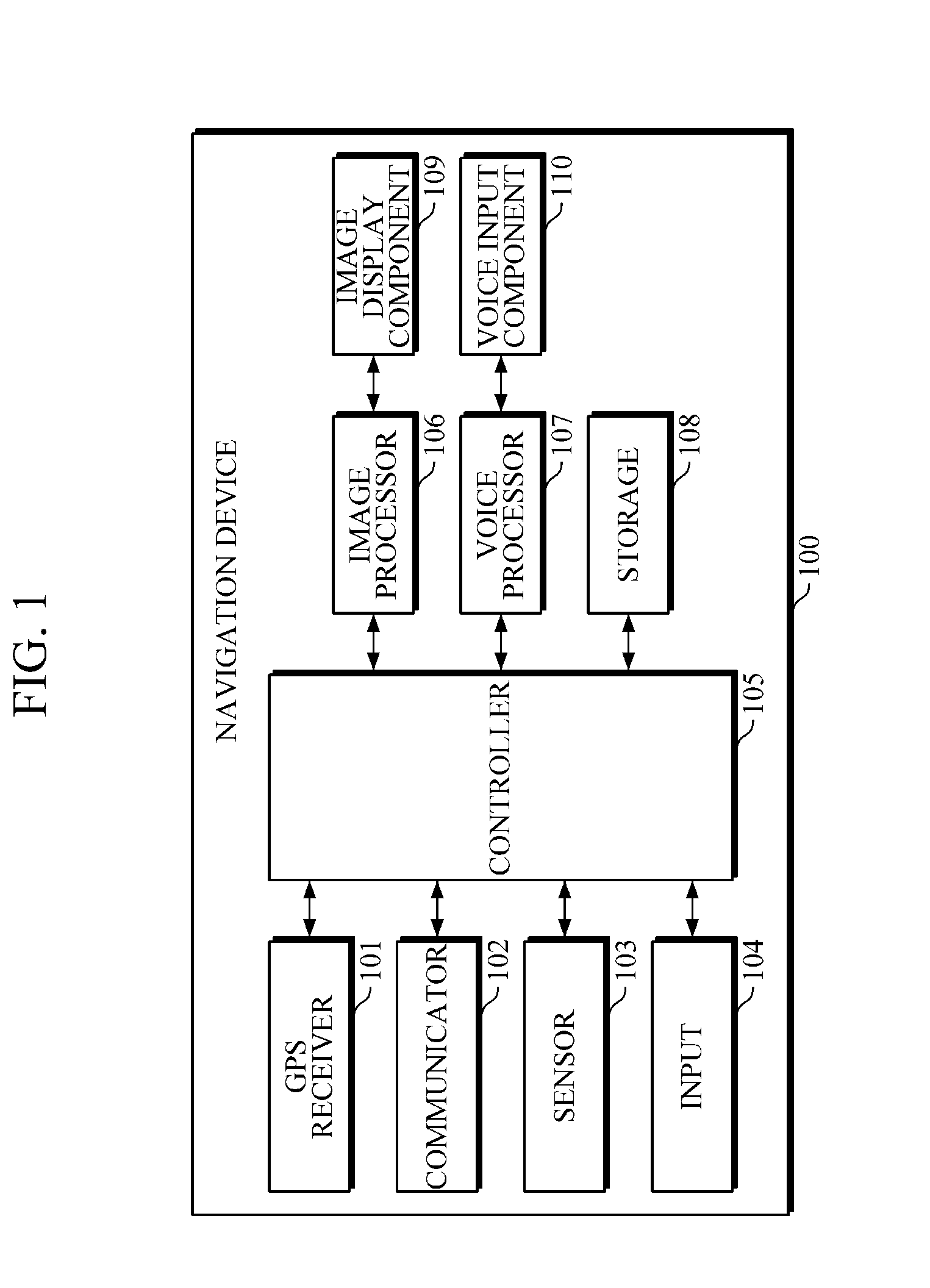
[0051]FIG. 1 is a block diagram schematically illustrating an example of a conventional navigation device.

[0052]Referring to FIG. 1, the navigation device 100 includes a global positioning system (GPS) receiver 101, a communicator 102, a sensor 103, an input 104, a controller 105, an image processor 106, a voice processor 107, a storage 108, an image display component 109, and a voice output component 110.

[0053]The navigation device 100 may be implemented by various methods. For example, the navigation device 100 may be installed ...


PUM


Abstract

An apparatus for processing metadata includes: a map node defining component configured to define a map node for setting a virtual map; a map overlay node defining component configured to define a map overlay node for setting a layer in which an augmented reality object is to be overlaid on a map set according to the map node; a map marker node defining component configured to define a map marker node for setting a position of the augmented reality object on the map, which is to be overlaid on the layer set according to the map overlay node; a point of interest node defining component configured to set information on a point of interest, which is a position of the augmented reality object on the map; and a controller configured to load the virtual map, the layer, the map marker, and the point of interest.

Description

CROSS-REFERENCE TO RELATED APPLICATION(S)[0001]This application claims priority from Korean Patent Application Nos. 10-2013-0127893, filed on Oct. 25, 2013, and 10-2014-0136848, filed on Oct. 10, 2014, in the Korean Intellectual Property Office, the entire disclosures of which are incorporated herein by references for all purposes.BACKGROUND[0002]1. Field[0003]The following description relates generally to a data processing technique, and more particularly to an apparatus and method for processing metadata in a map-based augmented reality navigation system implemented based on an MPEG-4 Binary Format for Scene (BIFS).[0004]2. Description of the Related Art[0005]Augmented reality (AR) refers to a technology that combines virtual objects or information with a real environment to make the virtual objects look as if they exist in a real environment. That is, AR is a technology that overlays three-dimensional (3D) virtual objects on a real world image. Unlike conventional virtual reality...

Claims


Application Information

Patent Timeline
IPC IPC(8): G06T19/00G06T11/60
CPCG06T11/60G06T19/006G01C21/367G06T9/00H04N19/25H04N19/27
Inventor CHOI, BUM SUKKIM, SOON CHOULHA, JEOUNG LAKJEONG, YOUNG HOHONG, JIN WOO
Owner ELECTRONICS & TELECOMM RES INST
Learn More