Low-energy consumption location of movable objects

a technology of low energy consumption and movable objects, applied in the field of system and method for locating movable objects, can solve the problems of gnss receivers and significant energy consumption of gnss, and achieve the effect of energy consumption of mobile stations

Active Publication Date: 2016-09-08
GATEKEEPER SYST
View PDF14 Cites 75 Cited by
  • Summary
  • Abstract
  • Description
  • Claims
  • Application Information

AI Technical Summary

Benefits of technology

[0007]In one implementation, a mobile station attached to or included in a movable object can communicate bidirectionally with a fixed base station to determine a location of the movable object. The bidirectional communication may be over a radio frequency (RF) link that is in an RF band that is unlicensed by radiocommunication authorities (e.g., a non-cellular communication band). The mobile station may communicate an estimated position to the base station. The estimated position may be based on dead reckoning by the movable object or information from non-GNSS position sensors at the movable object. The mobile station can receive from the base station a set of GNSS satellites that are visible to the mobile station. The mobile station can acquire satellite timing information from GNSS signals from the set of satellites and communicate minimally-processed satellite timing information to the base station. The base station can determine the position of the mobile station and communicate the position back to the mobile station. By offloading much of the GNSS position processing to the fixed base station (which is typically powered by a mains electric power system), energy consumption of the mobile station (which may be powered by a battery) is reduced.

Problems solved by technology

Estimating a movable object's location using a GNSS can require significant energy consumption in a GNSS receiver at the movable object, because the GNSS receiver must acquire and process GNSS signals from multiple GNSS satellites.

Method used


Image

  • Low-energy consumption location of movable objects
  • Low-energy consumption location of movable objects
  • Low-energy consumption location of movable objects

Examples


example pseudolites

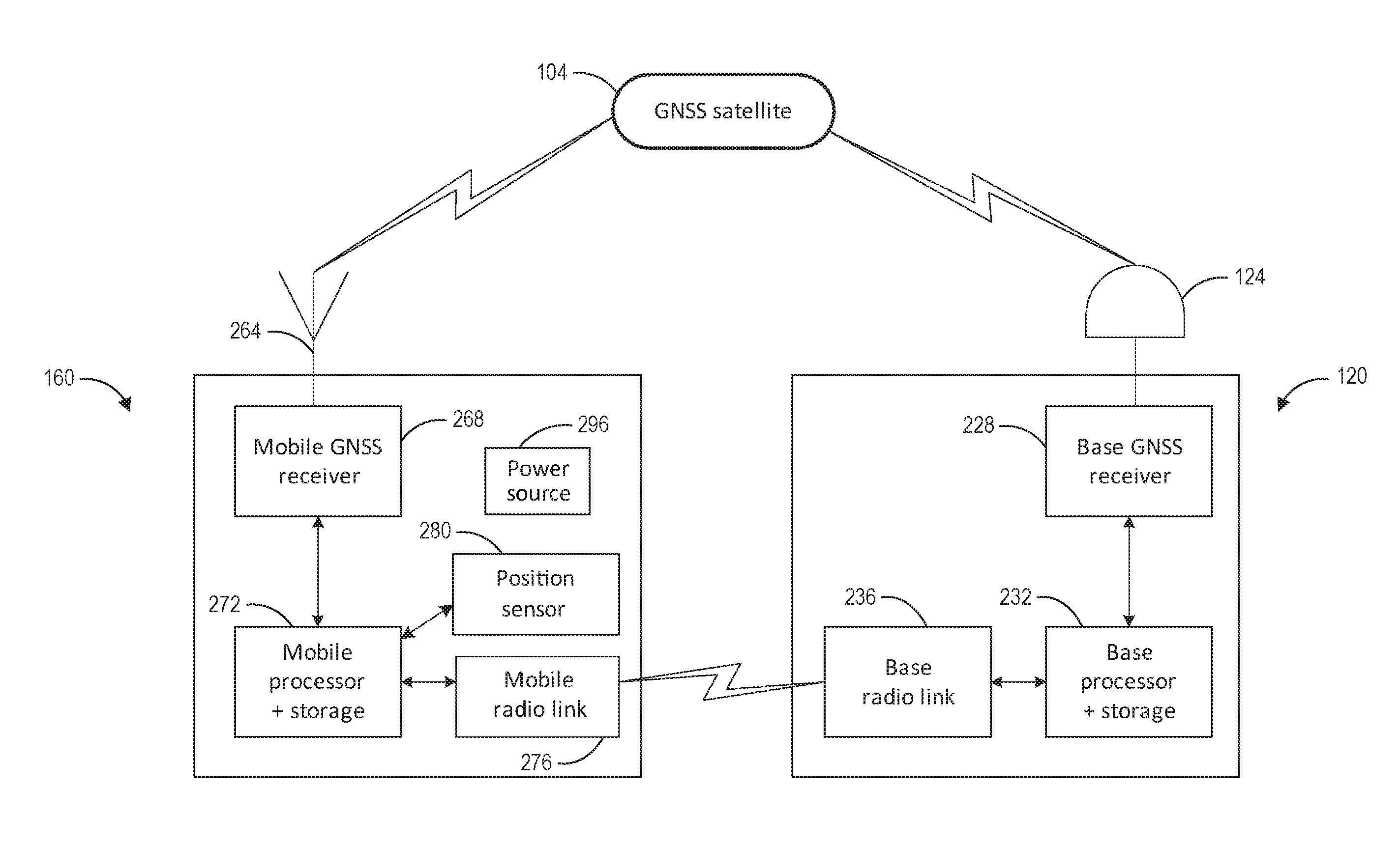
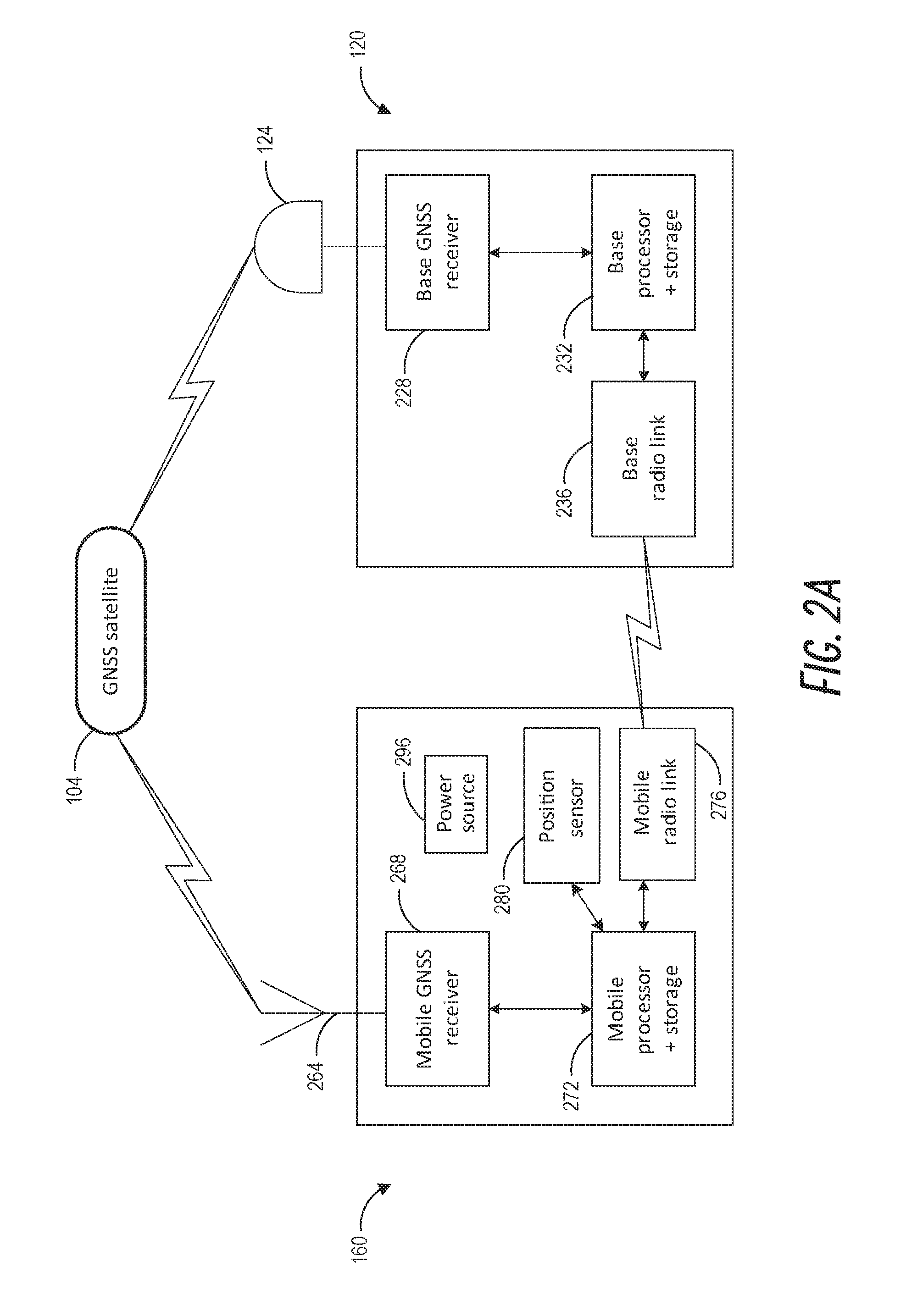
[0039]There are existing devices known as pseudolites (for “pseudo-satellites”) which transmit signals that mimic (to varying degrees) the GNSS signal structure, so that a suitably equipped GNSS receiver can maintain a position fix by receiving GNSS signals from a pseudolite when fewer than the minimum number of GNSS satellites are in view (including the case of no satellites in view). Pseudolites can be fixed in positions to create (at least in part) a ground-based positioning network. The GNSS receiver can be configured to receive signals from one or more pseudolites and / or one or more GNSS satellites to determine its position. One market for pseudolites is in mining, since GNSS RF signals cannot penetrate into the mine. Pseudolites can be placed in urban canyons, retail shopping centers, warehouses, indoor environments (where GNSS signals are blocked or weak), etc. to permit position determinations for objects in those spaces. In practice, pseudolites are almost always fixed in p...

example operation

Scenarios

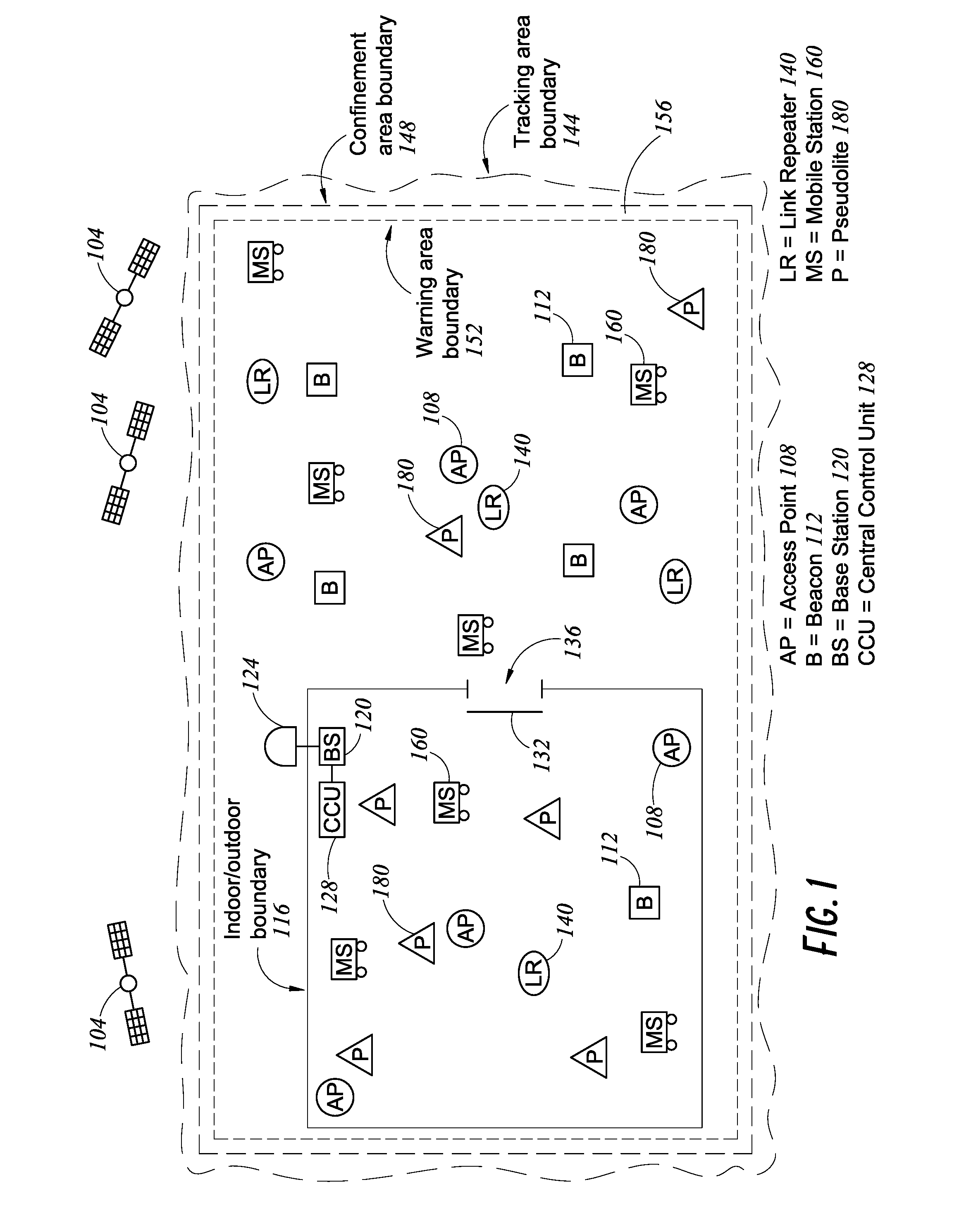
[0101]FIG. 6A illustrates examples of some operation scenarios of a low-power GNSS mobile system. A dashed line 620 denotes the boundary of a tracking area. Curves 640 and 660 illustrate movements of two mobile stations, mobile station A and mobile station B, respectively. Open circles on the curves denote positions when the mobile stations wake up from a sleep mode. Solid circles on the curves denote positions when the mobile stations enter a sleep mode. Small arrows from open circles illustrate direction of interest at that position / time. A direction of interest might include a direction toward a nearby mobile station or other obstacle (e.g., to avoid collision) or a direction toward the nearest portion of the tracking area boundary 620 (e.g., where a confinement action may occur in a geofencing scenario). Six arrows around the perimeter illustrate locations of GNSS satellites relative to the tracking area.

[0102]When more GNSS satellites are visible from a mobile station,...


PUM


Abstract

Low-energy consumption techniques for locating a movable object using a global satellite navigation system (GNSS) are provided. A mobile station attached to or included in a movable object can communicate bidirectionally with a fixed base station to determine a location of the movable object. The mobile station may communicate an estimated position to the base station and receive from the base station a set of GNSS satellites that are visible to the mobile station. The mobile station can acquire satellite timing information from GNSS signals from the set of satellites and communicate minimally-processed satellite timing information to the base station. The base station can determine the position of the mobile station and communicate the position back to the mobile station. By offloading much of the processing to the base station, energy consumption of the mobile station is reduced.

Description

CROSS-REFERENCE TO RELATED APPLICATIONS[0001]This application claims the benefit of priority to U.S. Patent Application No. 62 / 129,278, filed Mar. 6, 2015, entitled “Systems and Methods for Location of Movable Objects,” which is hereby incorporated by reference herein in its entirety.BACKGROUND[0002]1. Field[0003]The disclosure generally relates to systems and methods for locating movable objects and more particularly to systems and methods that use a global navigation satellite system (GNSS) to provide location estimates while using low energy at the movable objects.[0004]2. Description of Related Art[0005]GNSS techniques can be used to determine a location for a movable object. The GNSS can include a constellation of Earth-orbiting satellites that each broadcast coded radio frequency (RF) signals. The constellation may include 27 or more satellites so that multiple satellites are in the sky (above the horizon) over nearly any particular region of the Earth at any time. A GNSS rece...

Claims


Application Information

Patent Timeline
Patent Type & Authority Applications(United States)
IPC IPC(8): G01S19/05G01S19/11G01S19/43H04W4/02H04W4/029
CPCG01S19/05G01S19/11G01S19/43G01S19/252G01S19/09G01S19/06G01S19/34G01S19/14G01S19/28G01S19/49G01S19/41H04W4/021H04W4/023H04W4/024H04W4/025H04W4/029H04W64/00G01S19/485H04W4/02
Inventor CARTER, SCOTT J.
Owner GATEKEEPER SYST
Why Eureka
Try Eureka