Spatial predicates evaluation on geohash-encoded geographical regions
a geohash-encoded and geographical region technology, applied in the field of geographical information management, can solve the problems of lack of the aforementioned benefits associated with geohash-coded geometries, complexity of queries coupled with processing performance constraints, and the creation of new challenges in spatial temporal data analysis
- Summary
- Abstract
- Description
- Claims
- Application Information
AI Technical Summary
Benefits of technology
Problems solved by technology
Method used
Image
Examples
third embodiment
II-E-4. Use the Prefix Mask
[0120]A further embodiment of the contain module 685 in main stage 680 includes using a prefix mask. Since gL and gS have a common prefix {l0l1 . . . lS−2lS−1}={s0s1 . . . sS−2sS−1}, applying an XOR operation to gL and gS, gL⊕gS, should result in all zeros in the prefix region if contain (gS, gL) is true. In order to focus only on the prefix region, the remaining bits can be cleared by applying Maskshort 672. gL is contained in gS only if the short-masked XOR of gL and gS (i.e. gS⊕gŜMaskshort) contains all zeros.
gL={l0l1 . . . lS−2lS−1}∥{lS . . . lL−1}∥{0L . . . 0N−1}
gS={s0s1 . . . sS−2sS−1}∥{0S . . . 0L−1}∥{0L . . . 0N−1}
gL⊕gS={l0⊕s0 . . . lS−1⊕sS−1}∥{lS⊕0S . . . lL−1⊕0L−1}∥{0L . . . 0N−1}
(gL⊕gS)̂Maskshort={l0⊕s0 . . . lS−1⊕sS−1}∥{0S . . . 0L−1}∥{0L . . . 0N−1}
[0121]This algorithm can be equivalently expressed in pseudocode as follows:
1:gL⊕gS← XOR of gS and gL2:(gL⊕gS)short← Maskshort {circumflex over ( )} gL⊕gS3:if (gL⊕gS)short is all zeros then4: con...
first embodiment
II-H-1. Comparison with Constants
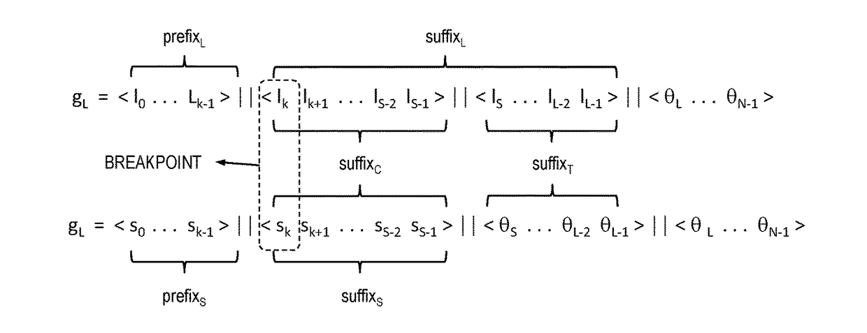
[0172]There are only limited cases for corner touch. After the breakpoint, the regions defined by the two geohashes push toward each other in two directions, vertical and horizontal, at same time, i.e. in the diagonal direction on grid. Thus, they must be in accordance with one of these two bit patterns:
[0173]Pattern (a):
gS=∥K1K+10K+20K+30K+40K+5 . . . 0S−20S−1>∥
gL=∥K0K+11K+21K+31K+41K+51K+6 . . . 1L−20L−1>∥
[0174]Pattern (b):
gS=∥K1K+11K+20K+31K+40K+5 . . . 0S−21S−1>∥
gL=∥K0K+10K+21K+30K+41K+50K+6 . . . 1L−20L−1>∥
[0175]As was described earlier for the external touch, bit values for latitude and longitude can be considered separately. For the corner touch, the condition for pushing towards should hold for both directions:
sK+2=sK+4= . . . =sK
sK+3=sK+5= . . . =sK+1
AND
lK+2=lK+4= . . . =lK
lK+3=lK+5= . . . =lK+1
[0176]Considering the entire geohash strings at once, there are only two particular bit patterns at the suffix strings. (a) If one of them, for exam...
second embodiment
II-H-2. Checking all Zeros or all Ones
[0178]If two geohash regions touch at their corner, they push toward each other in both dimensions, latitude and longitude. Thus, an illustrative embodiment can detect corner touch by adopting similar conditions from external touch for both latitude and longitude to push towards each other:
gL={l0l1 . . . lK−1}∥{lKlK+1 . . . lS−2lS−1}∥{lS . . . lL−2lL−1}∥{0L . . . 0N−1}
gS={s0s1 . . . sK−1}∥{sKsK+1 . . . sS−2sS−1}∥{0S . . . 0L−20L−1}∥{0L . . . 0N−1}
lK≠lK+2=lK+4=lK+6= . . . =sK
sK≠sK+2=sK+4=sK+6= . . .
lK+1≠lK+3=lK+5=lK+7= . . . =sK+1
sK+1≠sK+3=sK+5=sK+7= . . .
[0179]Therefore, these two geohashes should be in this form:
gL={prefix}∥{xyxyxy. . . xy. . . }∥{0 . . . 0}
gS={prefix}∥{xyxyxy . . . }∥{0 0 . . . 0 0}
[0180]There are only two cases depending on a bit at a breakpoint of each geohash for latitude or longitude:
Case (A-1):Case (B-1):If a bit at a breakpoint of gs=1 (sK=x=1)If a bit at the next to breakpointof gs=1 (sK+1=y=1)sK = 1, sK+2 = sK+4 = s...
PUM
 Abstract
Description
Claims
Application Information
 - R&D
- Intellectual Property
- Life Sciences
- Materials
- Tech Scout
- Unparalleled Data Quality
- Higher Quality Content
- 60% Fewer Hallucinations
Browse by: Latest US Patents, China's latest patents, Technical Efficacy Thesaurus, Application Domain, Technology Topic, Popular Technical Reports.
© 2025 PatSnap. All rights reserved.Legal|Privacy policy|Modern Slavery Act Transparency Statement|Sitemap|About US| Contact US: help@patsnap.com


