Method for creating a constellation of electronic devices for providing optical or radio-frequency operations on a predetermined geographical area, and a system of such a constellation of electronic devices

a technology of optical or radio-frequency operations and electronic devices, which is applied in the direction of free-space transmission, network topologies, transmission, etc., can solve the problems of launch cost, increased cost of higher orbit applications, and difficulty in determining the launch opportunity, so as to save costs and improve the resolution of optical or radio-frequency (radar) instruments. , the effect of reducing the distance to the earth surfa

Inactive Publication Date: 2018-02-08
EURON SPACE AGENCY ESA
View PDF7 Cites 19 Cited by
  • Summary
  • Abstract
  • Description
  • Claims
  • Application Information

AI Technical Summary

Benefits of technology

[0048]Moreover, since the electronic device according to the invention remains relatively close to earth within altitudes used by airplanes, no protection of the electronic device against space environment is needed. This also saves costs.
[0049]Also, as the distance to the earth surface is smaller than the distance from space, optical or RF (radar) instruments resolution is consequently improved.
[0050]Furthermore, since the altitudes at which the electronic device is operating are less than during operation in space, the relative attenuation of signals due to distance between the electronic device and an earth based user terminal or ground station is also less. As a result, lower gain antennas may be used in comparison to space operated satellite devices, providing equivalent or better link budget performance (note also that power on a plane is not a major issue and EIRP can be further improved). For example, instead of using a pointing horn (with about 20-23 dbi gain) or even a higher gain reflector or array antenna, requiring pointing mechanisms and / or electronic, a hemispherical coverage blade or patch antenna (with about 0 to 3 dbi gain) may be considered, resulting in a major simplification of the (electronic part of the) payload.
[0051]The user terminal or ground station may also have a simpler set-up with relatively reduced costs.
[0052]Another advantage of the constellation resulting from the reduced distance between the electronic device and an earth based user terminal or ground station is the lower transmission latency, which is lower than any space based system.
[0053]A further advantage is a lower Doppler shift, as the relative speed of airplanes to the ground or between airplanes is smaller than the relative speed of satellite to ground or between satellites.

Problems solved by technology

A key issue is the launch cost.
Higher orbit applications will cost even more.
In addition, the availability of launch opportunity is an issue for large constellations, i.e., a large number of satellites that cooperate in the constellation.
The launch cost and availability issues, incited developers to look for alternative platforms such as high altitude UAV's (Unmanned Aerial Vehicles) or stratospheric balloons.
Several issues are raised for such systems.
Moreover, flight of UAV's needs to be controlled from the ground by the operators of the UAV's, therefore each UAV needs to be in sight of a control ground station and this makes the system even more expensive to operate in addition to its design and building.
Also for stratospheric balloons, regulatory and in addition operational issues exist in relation to the control of orbits of such balloons, in particular within the stratospheric air streams that are considered for their operations.
Furthermore, Smallsats have to be compatible with space environment, which makes design / testing / manufacturing correspondingly costly.
Considering cost issues, a trade-off is typically made between reliability and lifetime of Smallsats.
Also, the large number of satellites in Smallsats LEO constellations and lack of clear de-orbit policies for Smallsats at end-of-lifetime, is an issue for space debris.

Method used


Image

  • Method for creating a constellation of electronic devices for providing optical or radio-frequency operations on a predetermined geographical area, and a system of such a constellation of electronic devices
  • Method for creating a constellation of electronic devices for providing optical or radio-frequency operations on a predetermined geographical area, and a system of such a constellation of electronic devices
  • Method for creating a constellation of electronic devices for providing optical or radio-frequency operations on a predetermined geographical area, and a system of such a constellation of electronic devices

Examples


Embodiment Construction

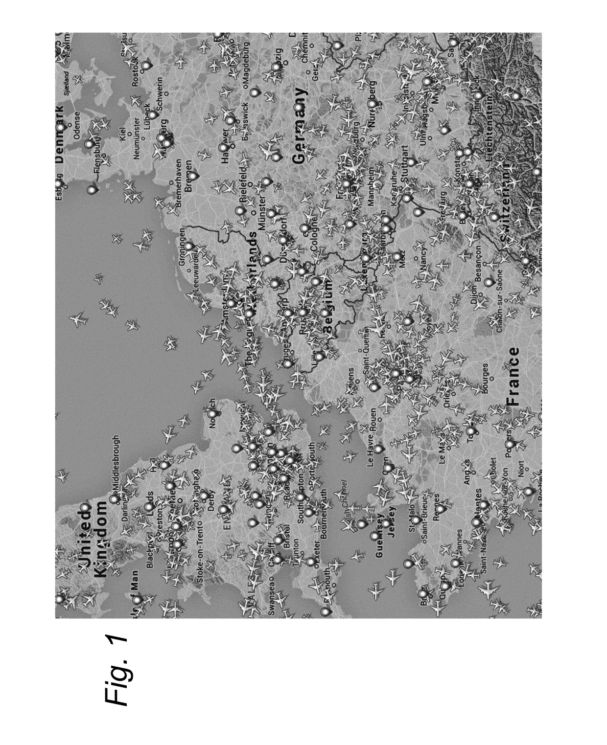
[0062]FIG. 1 shows an example screen dump of a display showing air traffic density for commercial airplanes on a weekday morning over a part of western Europe.

[0063]During most time of the day, a continuous stream of commercial airplanes between various airfields can be observed. Such airplanes follow predetermined routes across western Europe based on a timing schedule of flights. Typically, due to the relatively high density of traffic, the inter-plane distance along these routes is regulated to a minimal (but still safe) distance. Similar air traffic patterns can be found in many other regions.

[0064]During flight, each airplane moves along its scheduled route at a cruising altitude of typically about 10 km.

[0065]The maximum line-of-sight range or individual airplane coverage R as a function of altitude A can be estimated by equation 1:

R˜√{square root over (2×Re×A)}  (eq.1)

[0066]In eq. 1 Re is the earth radius (6371 km) and all values are in km.

[0067]For an altitude of 10 km, the ...


PUM


Abstract

A method and system for creating a constellation of electronic devices for providing optical or radio-frequency operations relating to earth surface data collection applications on a predetermined geographical area. On each of a plurality of (commercial) airplanes at least one electronic device from the constellation is provided, and during its flight each airplane has a flight path over at least a portion of the geographical area. Each electronic device is configured for the operations during the flight with an earth coverage range for the operations determined by an individual airplane coverage range of a portion of the earth surface as provided by the associated airplane. One or more electronic devices are activated for the operations when the individual airplane coverage of the one or more airplanes associated with the one or more electronic devices is within the geographical area.

Description

FIELD OF THE INVENTION[0001]The present invention relates to a method for creating a constellation of electronic devices for providing optical or radio-frequency operations relating to earth surface data collection applications on a predetermined geographical area. Also, the invention relates to a class of electronic devices and a system of such a constellation of electronic devices.PRIOR ART[0002]There has been considerable interest and work recently on small satellites with mass as low as 1 up to 50 kg. Several ‘small’ satellites (Nanosats, Cubesats, Microsats—hereafter called Smallsats) and constellations of them have been proposed / developed.[0003]Various companies offer solutions based for instance on the Cubesat standard. A Cubesat is a nano-satellite whose design is compliant with the CubeSat standard and whose volume is a multiple of a single CubeSat unit (10×10×10 cm3, <1.33 kg) ranging from 2 units up to 6 units. A 3 U small satellite (composed by 3 standard Cubesat unit...

Claims


Application Information

Patent Timeline
Patent Type & Authority Applications(United States)
IPC IPC(8): B64D47/06H04W84/00H04B10/118
CPCB64D47/06H04B10/118H04W84/005H04B7/18504H04B7/18508
Inventor RAMMOS, EMMANUEL
Owner EURON SPACE AGENCY ESA
Why Eureka
Try Eureka