Unlock instant, AI-driven research and patent intelligence for your innovation.

Utilization of National Cellular Infrastructure for UAV Command and Control

Inactive Publication Date: 2019-01-17
BIRKET IP HLDG INC
View PDF0 Cites 8 Cited by
  • Summary
  • Abstract
  • Description
  • Claims
  • Application Information

AI Technical Summary

Benefits of technology

The patent describes a system that can detect drones and other small objects in a certain area, and track them to their destination. The system uses a network of towers and detection devices to identify and locate the drones, and can also track them while they operate. The system can also use interceptor craft to detect and disable drones, and communicate the information about them to other areas. The system also allows land or aerial vehicles to act as additional eyes on the ground in areas where there are no cellular towers. Overall, the system improves security and monitoring of drone activities in restricted areas.

Problems solved by technology

Constant transmission of the transponder signal may cause an unacceptable drain on power resources, so this tradeoff will be determined by the system developers designing the particular network.

Method used


Image

  • Utilization of National Cellular Infrastructure for UAV Command and Control

Examples


Embodiment Construction

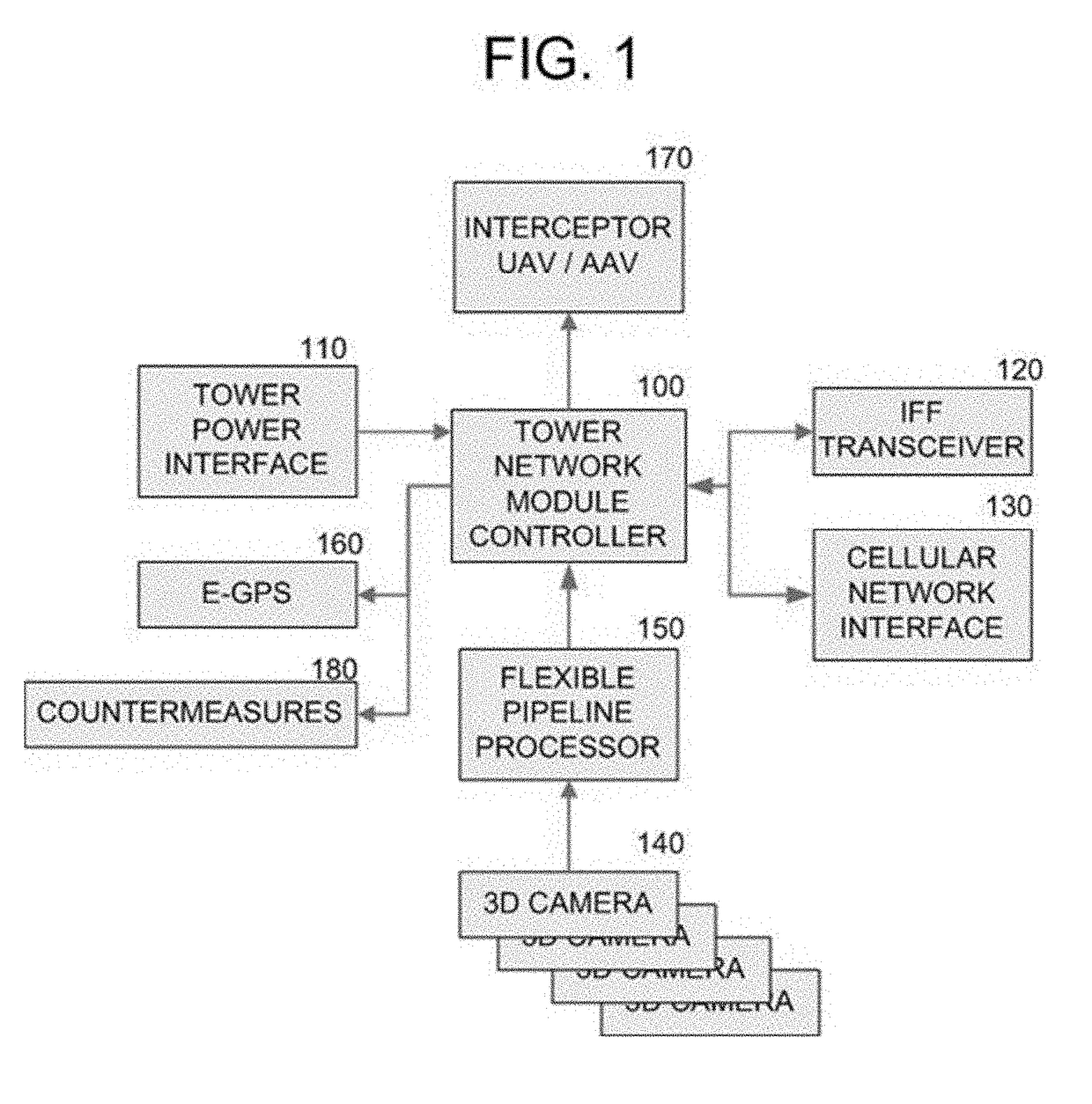
[0027]In accordance with an embodiment of the present invention, a system employing cellular networks and / or infrastructure is provided to facilitate command and control of remotely piloted and autonomous vehicles. A module controller with cellular network interface and direction and ranging sensor such as but not limited to 3D cameras may be used to respond to Identify Friend or Foe (IFF) messages transmitted from vehicles and correlate the data and transmit location, bearing, and other data to one or more entities of an overall air traffic control system. The data from one or more 3D cameras may be pre-processed but additional hardware or software systems to present only the correlation data needed by the module controller. Enhanced Global Positioning Satellite transmitters may be included to assist in the navigation and control of autonomous vehicles and / or surface GPS systems. System power may be provided by the cellular network tower. A vehicle remotely piloted or autonomous pl...


PUM


Abstract

Unmanned Aerial Vehicles also known as UAVs or Drones, either autonomous or remotely piloted, may be fitted with an Identify Friend or Foe (IFF) transponder for tracking and identification. Remotely piloted drones require a high bandwidth RF transceiver for video and / or control inputs, but the IFF system does not. Fully autonomous vehicles might utilize only the low bandwidth IFF transponder. This invention utilizes the existing cellular network and physical infrastructure to provide UAV command and control functionality over most of the national area.

Description

CROSS-REFERENCE TO RELATED APPLICATIONS[0001]U.S. 62 / 275,717 Jan. 6, 2016STATEMENT REGARDING FEDERALLY SPONSORED RESEARCH OR DEVELOPMENT[0002]Not ApplicableREFERENCE TO SEQUENCE LISTING, A TABLE, OR A COMPUTER PROGRAM LISTING COMPACT DISK APPENDIX[0003]Not ApplicableFIELD[0004]This invention relates generally to cellular radio infrastructure and more specifically to the utilization of cellular infrastructure for UAV command and control.BACKGROUND[0005]Piloted drones require high bandwidth RF transceivers for pilot video and / or control inputs and are loath to add IFF data to that stream. Domestic (non-military) transceivers are most often point to point connections in the unlicensed Industrial / Scientific / Medical (ISM) bands. IFF data may need to be transmitted to entities such as the FAA in addition to just the pilot control console, such that the point to point connection is insufficient to implement the functionality of the IFF transponder even though it may be low bandwidth.[0006]...

Claims


Application Information

Patent Timeline
IPC IPC(8): H04B7/185H04W4/38H04W4/44G08G5/00F41H11/02F41H13/00B64C39/02G01S19/11G01S13/78
CPCH04B7/18506H04W4/38H04W4/44G08G5/0082G08G5/0069G08G5/0013B64C2201/127F41H13/005B64C39/024G01S19/11G01S13/78H04W92/10F41H11/02H04W16/26F41G9/00H04B7/2606B64U2201/00B64U2101/30
Inventor RUSSELL, DAVID WAYNE
Owner BIRKET IP HLDG INC
Features
  • R&D
  • Intellectual Property
  • Life Sciences
  • Materials
  • Tech Scout
  • Unparalleled Data Quality
  • Higher Quality Content
  • 60% Fewer Hallucinations
Learn More