Radar-based system and method for real-time simultaneous localization and mapping

Active Publication Date: 2019-12-19
ARBE ROBOTICS LTD
View PDF0 Cites 19 Cited by
  • Summary
  • Abstract
  • Description
  • Claims
  • Application Information

AI Technical Summary

Problems solved by technology

Naturally, this type of flight control is limited to small areas in the field of view of the user.
However, image processing methods involves very complex algorithms, which requires a strong processing core, do not work under all weather and conditions and have poor estimation of distance.
Another drawback of image processing is the high power consumption of the system.
Image processing with high resolution requires expensive equipment to be installed on the moving platform, expensive and power consuming software (processing program) and hardware—computer and processor that are capable of performing complicated data processing operations as fast as possible.
In case of a UAV, even more than any other moving platform, hardware constraints include low weight, small size and low-power requirements, since

Method used


Image

  • Radar-based system and method for real-time simultaneous localization and mapping
  • Radar-based system and method for real-time simultaneous localization and mapping
  • Radar-based system and method for real-time simultaneous localization and mapping

Examples


Embodiment Construction

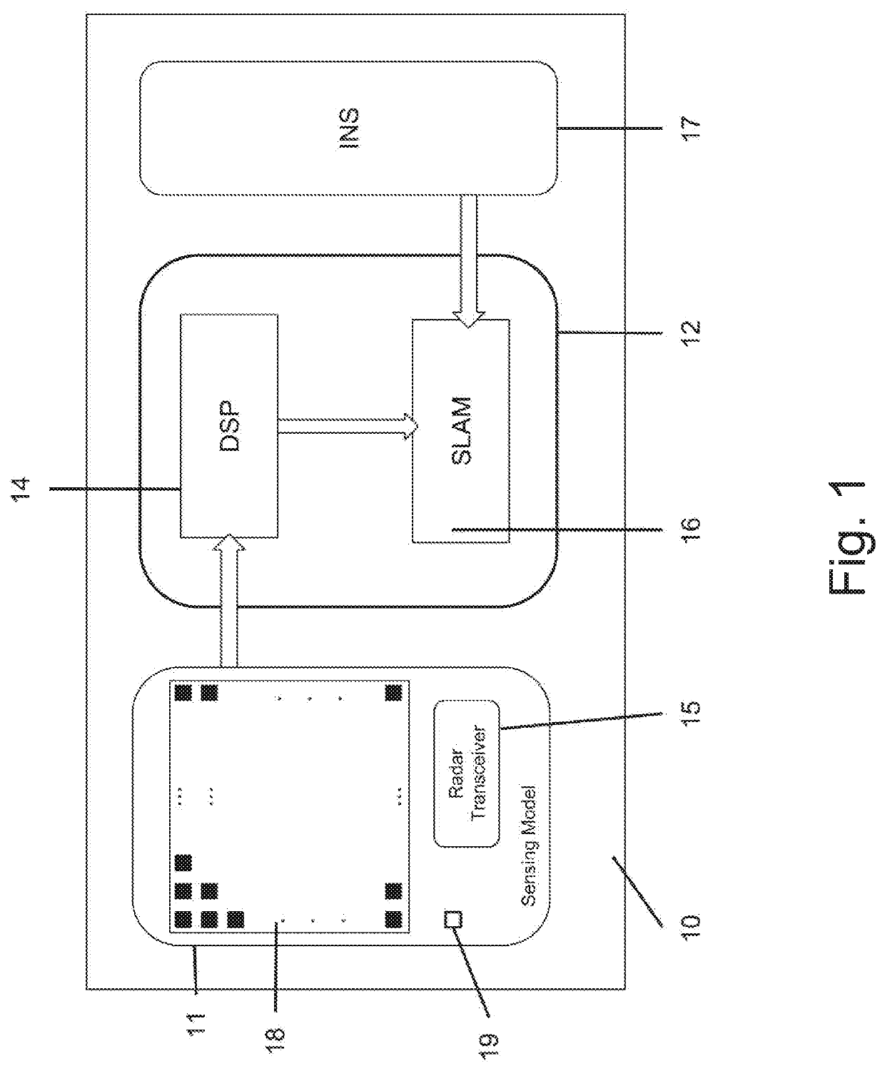
[0073]The present invention provides a method and a system for mapping and localization of the objects in the surroundings with respect to an autonomously controlled moving platform. The principle of operation of the system proposed by the present invention is based on a new and unique variation on the known Simultaneous Localization and Mapping (SLAM) technology with respect to sensors that translate their surroundings to a cloud of points, where for each point, it is possible to calculate the probability to be a target, another probability not to be a target and the probability of unknown points that are blocked from the radar view (e.g., a radar sensor). All different probabilities can be calculated directly by the DSP of the radar or deduced from the amplitude and / or the SNR of the point and knowledge of the radar performance. SLAM is a computer algorithm that maps an environment by determining the location of the sampling device and saving the environmental information collecte...


PUM


Abstract

A method for performing Simultaneous Localization And Mapping (SLAM) of the surroundings of an autonomously controlled moving platform (such as UAV or a vehicle), using radar signals, comprising the following steps: receiving samples of the received IF radar signals, from the DSP; receiving previous map from memory; receiving data regarding motions parameters of the moving platform from an Inertial Navigation System (INS) module, containing MEMS sensors data; grouping points to bodies using a clustering process; merging bodies that are marked by the clustering process as separate bodies, using prior knowledge; for each body, creating a local grid map around the body with a mass function per entry of the grid map; matching between bodies from previous map and the new bodies; calculating the assumed new location of the moving platform for each on the mL particles using previous frame results and new INS data; for each calculated new location of the mL particles with normal distribution, sampling N assumed locations; for each body and each body particle from the previous map and for each location particle, calculating the velocity vector and orientation of the body between previous and current map, with respect to the environment using the body velocity calculated in previous step and sampling N2 particles of the body, or using image registration to create one particle where each particle contains the location and orientation of the body in the new map; for each particle from the collection of particles of the body: propagating the body grid according the chosen particle; calculating the Conflict of the new observed body and propagated body grid, using a fusion function on the parts of the grid that are matched; calculating Extra Conflict as a sum of the mass of occupied new and old grid cells that do not have a match between the grids; calculating particle weight as an inverse weight of the combination between Conflict and Extra conflict; for each N1 location particle, calculating the weight as the sum of the best weight per body for that particle; resampling mL particles for locations according to the location weight; for each body, choosing mB particles from the particles with location in one of the mL particles for the chosen location, and according to the particles weights; for each body and each one of the mB particles calculate the body velocity using motion model; and creating map for next step, with all the chosen particles and the mass function of the grid around each body, for each body particle according to the fusion function.

Description

FIELD OF THE INVENTION[0001]The present invention relates to the field of simultaneous mapping of the environment while localizing of moving platforms, such as vehicles (e.g., autonomous cars), robots, and Unmanned Aerial Vehicles (UAVs, such as drones) in the environment. The invention can be used but not limited to mapping systems and / or collision avoidance systems and / or guidance systems for moving platforms. More particularly, the invention relates to a system and method for real-time Simultaneous Localization And Mapping (SLAM) for sensing devices that provide a point cloud (a point cloud is a set of data points in some coordinate system, which are intended to represent the external surface of an object) output.BACKGROUND OF THE INVENTION[0002]As technology development is rapidly increasing, the demand for autonomous moving platforms has also increased. One of the widespread moving platforms is an autonomous car. Another moving platform is a drone.[0003]An autonomous car elimin...

Claims


Application Information

Patent Timeline
IPC IPC(8): G05D1/02G01S13/32G01S13/86G01S13/89
CPCG01S13/89G01S13/86G05D1/0274G01S13/32G05D1/0272G05D1/027G01S13/933
Inventor FUCHS, RONIT ROXANARATHAUS, BEN
Owner ARBE ROBOTICS LTD
Why Eureka
Try Eureka