Supercharge Your Innovation With Domain-Expert AI Agents!

Inland river lidar navigation system for vessels and operation method thereof

a navigation system and lidar technology, applied in navigation instruments, surveying and navigation, instruments, etc., can solve the problems of difficulty in navigation path navigation, and difficulty in navigating path planes

Pending Publication Date: 2022-06-02
SHIP & OCEAN INDUSTRIES R&D CENTER
View PDF4 Cites 1 Cited by
  • Summary
  • Abstract
  • Description
  • Claims
  • Application Information

AI Technical Summary

Benefits of technology

The present invention provides an inland river Lidar navigation system and operation method for vessel. The system uses Lidar navigation to navigate on inland waters. The invention's advantage is that it calculates sensor data in real-time, continuously, which helps to discard irrelevant points and speed up the calculations. The system includes a receiver, memory, processor, and display for the vessel. The invention also provides an operation method for the system, including steps for receiving point clouds, integrating them, identifying entities, and processing them to display them on the map data. The system can automatically generate a height threshold based on terrestrial information and define the second point cloud set based on the height threshold and water information. Overall, the invention simplifies the navigation process for vessel on inland waters.

Problems solved by technology

Navigation for path plane is a basic issue for autonomous unmanned vessels.
According to the several kinds of disturbance (reflections of water or streams of water and wind) on the surface of water, the challenge of abilities to renew or to update the best paths in a short period, even in real time that the environment keeps in changing becomes harder.
For instance, a vessel sails, and the obstacles of the sailing environment may keep changing their locations or shapes above / under water by time passes.
Moreover, the large floating obstacles shift the location due to the flow of water.

Method used


Image

  • Inland river lidar navigation system for vessels and operation method thereof
  • Inland river lidar navigation system for vessels and operation method thereof
  • Inland river lidar navigation system for vessels and operation method thereof

Examples


Embodiment Construction

[0015]To clarify the purpose, technical solutions, and the advantages of the disclosure, embodiments of the present disclosure will now be described more fully hereinafter with reference to the accompanying drawings.

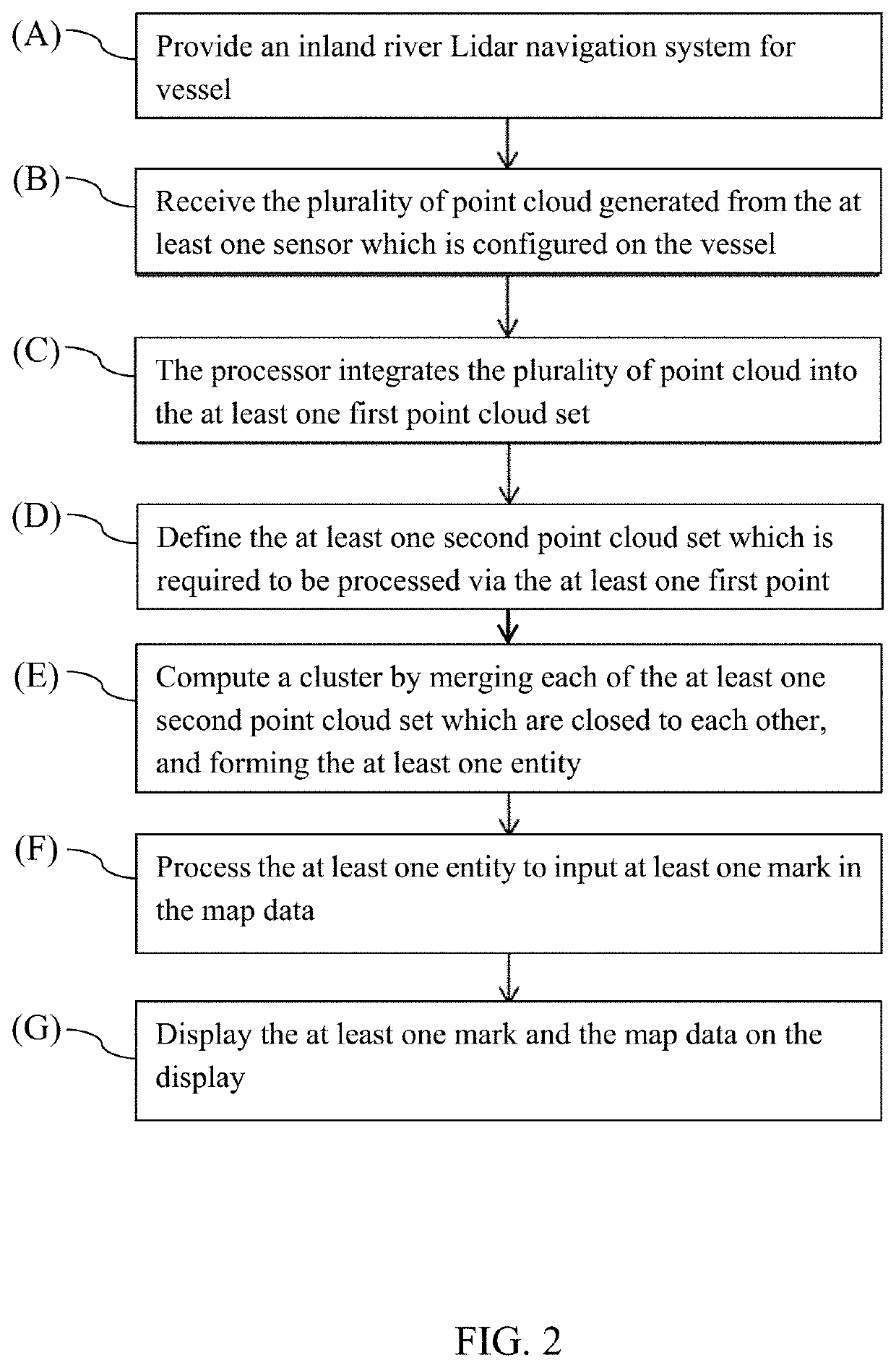
[0016]At least one embodiment of the present invention discloses an inland river Lidar navigation system and operation method for vessel. Specifically, this embodiment indicates a system used for Lidar navigation when vessels sail on river inland.

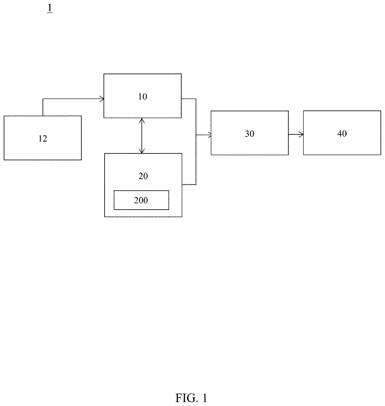
[0017]Please refer to FIG. 1, FIG. 1 is a schematic diagram of an embodiment of the present invention. The inland river Lidar navigation system 1 for vessel 100 comprises a receiver 10, a memory 20, a processor 30 and a display 40. The receiver 10, memory 20, and display 40 connect to processor 30 in this embodiment.

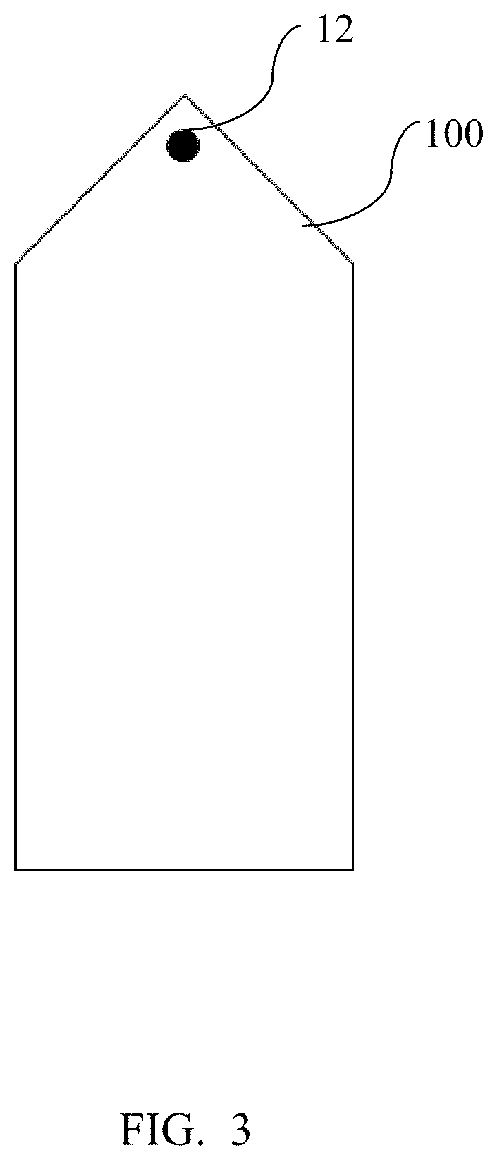
[0018]The receiver 10 illustrated in FIG. 1 receives the point cloud which is collected from the at least one sensor 12, and saves or sends one or more point clouds to the memory 20 or processor 30 alternatively. In ...


PUM


Abstract

This invention discloses an inland river Lidar navigation system for vessels, comprising a receiver, a memory, a processor and a display. The processor coupled to the receiver and the memory, and the display coupled to the processor. Overall, the inland river navigation Lidar system based on Lidar is able to make use of the preset map data identification uncalculatable points of a point cloud of the predetermined procedure, thereby removing of the alignment step in traditional method can be omitted. Therefore, the processing speed can be improved.

Description

TECHNICAL FIELD[0001]The present invention is an inland river Lidar navigation system for vessels and operation method thereof. Specifically, this invention indicates a system used for Lidar navigation when vessels sail on river inland.BACKGROUND OF RELATED ARTS[0002]Navigation for path plane is a basic issue for autonomous unmanned vessels. In other words, the central processor of a computer demands and decides the path which the vessels should follow and reach the target point, avoiding any collisions or decreasing the possibility per se in the sailing environment. According to the several kinds of disturbance (reflections of water or streams of water and wind) on the surface of water, the challenge of abilities to renew or to update the best paths in a short period, even in real time that the environment keeps in changing becomes harder.[0003]For instance, a vessel sails, and the obstacles of the sailing environment may keep changing their locations or shapes above / under water by...

Claims


Application Information

Patent Timeline
Patent Type & Authority Applications(United States)
IPC IPC(8): G01S17/89G01S17/08G01S7/48G01S7/51
CPCG01S17/89G01S7/51G01S7/4808G01S17/08G05D1/0206G01S17/93G01C21/3804G01C21/3667G01C21/203
Inventor HSU, MING-HSIANGLIAO, CHI-MINCHU, CHUN-HAN
Owner SHIP & OCEAN INDUSTRIES R&D CENTER
Features
  • R&D
  • Intellectual Property
  • Life Sciences
  • Materials
  • Tech Scout
  • Unparalleled Data Quality
  • Higher Quality Content
  • 60% Fewer Hallucinations
Learn More