Method for orthocorrecting satellite-acquired image

a satellite acquisition and image technology, applied in image enhancement, maps/plans/charts, instruments, etc., can solve the problems of complex calculation, and inability to apply the first correction method,

Inactive Publication Date: 2004-10-26
HITACHI SOFTWARE ENG
View PDF5 Cites 33 Cited by
  • Summary
  • Abstract
  • Description
  • Claims
  • Application Information

AI Technical Summary

Benefits of technology

(1) Using the given elevation data DEM, ground-relief-associated distortions caused by the relief of a ground surface can be corrected.
(2) Because the different bilinear models are used for the respective blocks, an error propagation caused by the determination of model formulas by the least-squares method does not occur.
(3) Distortion models are continuous at the boundary between each two adjacent blocks.
(4) Modeling can be performed even if no ground control points are available.
(5) If there are ground control points, the accuracy of the modeling can be improved further by estimating errors, which may be contained in orbital data and attitude data of the satellite, on the basis of the ground control points and correcting the errors.
Owing to these advantageous effects, the method according to the present invention for the orthocorrection of a satellite image is practical in both accuracy and the amount of calculations.

Problems solved by technology

Between adjacent blocks, however, distortions may be different.
This calculation, however, is very complex and is time-consuming.
The first correction method, however, involves the following problems:
(1) Since ground control points are indispensable for modeling, the first correction method cannot be applied where no ground control points are available as in a region where no map or the like is ready for use.
(2) The accuracy of modeling is dependent on the number and arrangement of ground control points. Depending on their number and arrangement, the accuracy of estimation of the coefficients in polynominals may deteriorate, and especially, there is a potential problem that an error may propagate through points other than the ground control points.
(3) A calculation by the formula (1) is needed for each pixel of corrected images, leading to an increase in the amount of calculations for the correction.
The second correction method, on the other hand, has problems in that, because approximation is effected with a rotating ellipsoidal model that the ground surface does not roll, the second correction method cannot be applied directly to an orthocorrection which takes into consideration elevation data DEM of an observation target region and ground-relief-associated distortions caused by the relief of the ground.

Method used


Image

  • Method for orthocorrecting satellite-acquired image
  • Method for orthocorrecting satellite-acquired image
  • Method for orthocorrecting satellite-acquired image

Examples


Embodiment Construction

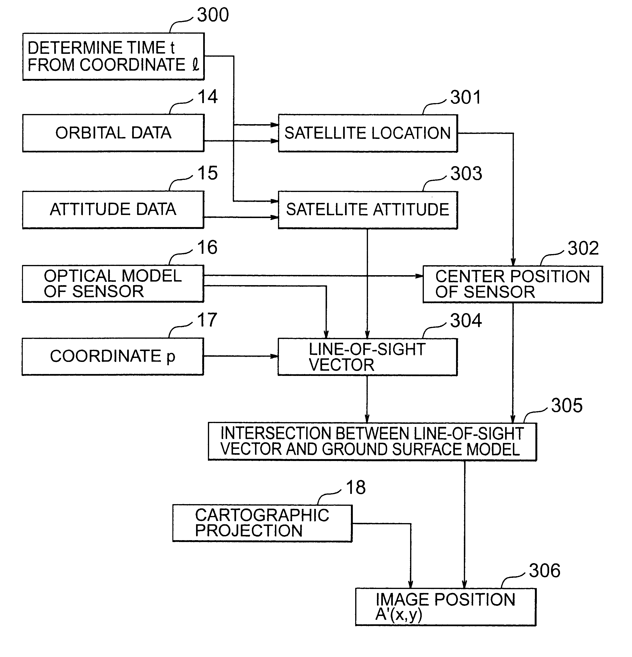
The embodiment of the present invention will hereinafter be described with reference to the drawings.

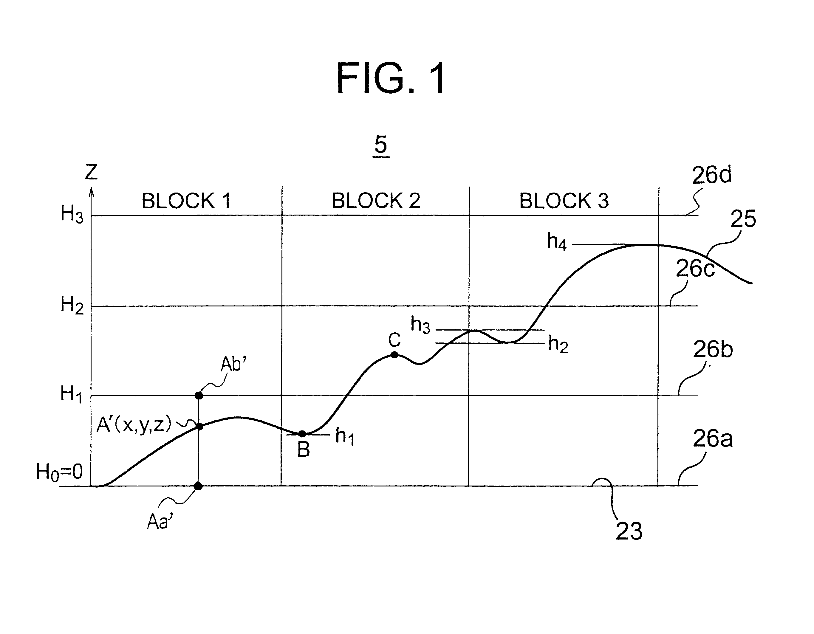
In FIG. 1, signs 26a,26b,26c,26d indicate control planes, respectively.

In FIG. 1, a ground surface 25 is shown in cross-section, and the plural different control planes 26a,26b,26c,26d are set on a corrected image 5. The control plane 26a is set as a control plane of a zero elevation (H.sub.0 =0) of a reference rotating ellipsoidal ground surface model 23, the control plane 26b as a control plane of elevation H.sub.1, the control plane 26c as a control plane of elevation H.sub.2, and the control plane 26d as a control plane of elevation H.sub.3. These elevations H.sub.0,H.sub.1,H.sub.2,H.sub.3 satisfy the following inequality: H.sub.0

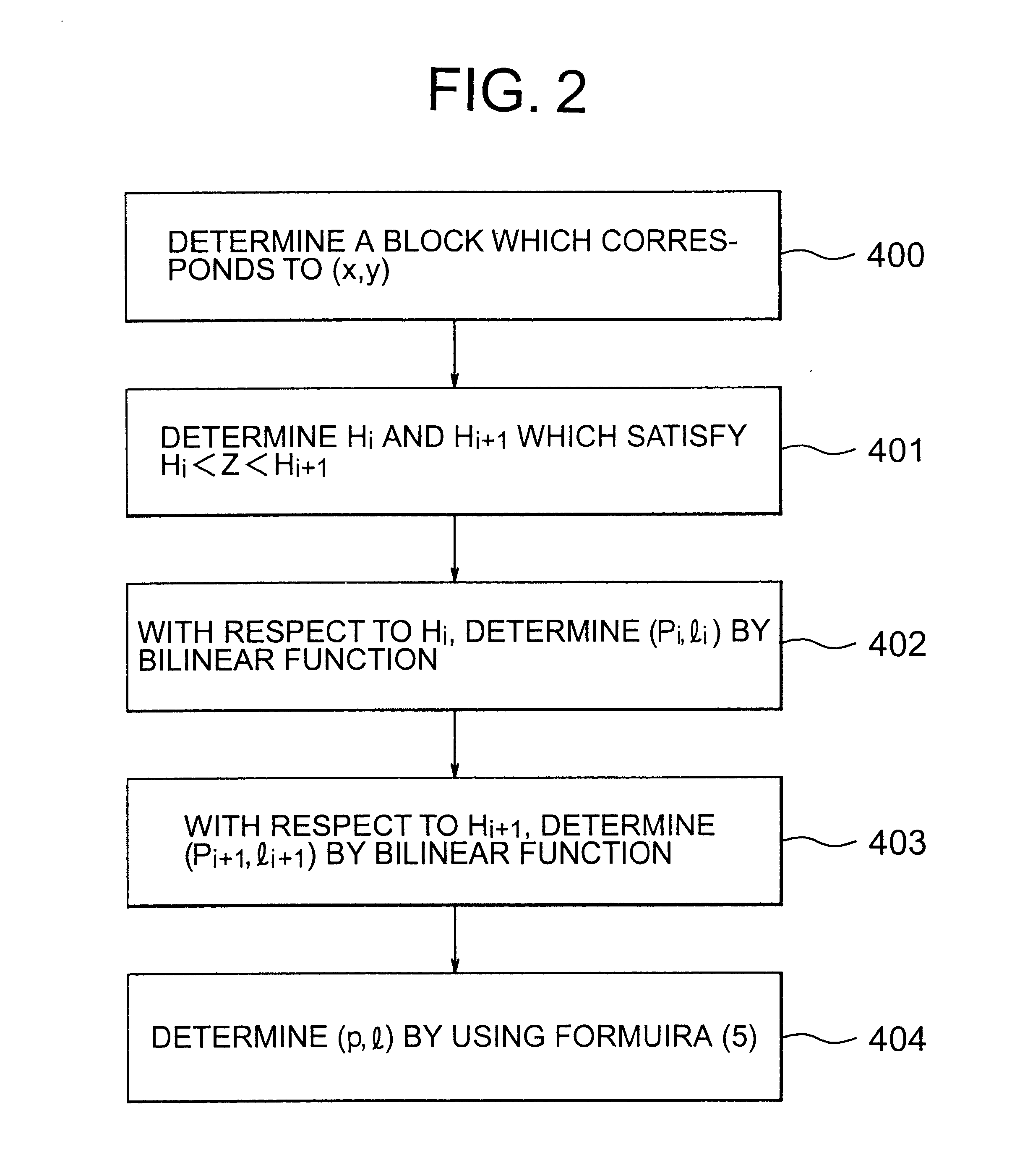
FIG. 1 also shows blocks 1,2,3. In every block, bilinear functions are determined for the respective control planes. With respect to every control plane, a p...


PUM


Abstract

A method is provided for the orthocorrection of a satellite-acquired image. This method can be applied even if ground control points are not set. Without propagation of an error throughout the image and also without needing an excessively large amount of calculations, the method makes it possible to correct ground-relief-associated distortions caused by the relief of a ground surface. According to the method, a plurality of control planes of different elevations are set relative to a control plane of a zero elevation of a reference rotating ellipsoidal earth model. A corrected image is divided into blocks by lattices of equal intervals. With respect to each of these blocks, distortion model formulas in the form of bilinear functions are determined for the respective control planes. Concerning each pixel position in the corrected image, two pixel positions in an observed image, which correspond to the elevation value of the pixel position in the block, are calculated by using distortion model formulas for two control planes which directly sandwich the value of elevation above and below the value in the corresponding block. By the value of elevation, the two pixel positions are linearly interpolated to determine the desired pixel position in the observed image.

Description

a) Field of the InventionThis invention relates to an image processing method for correcting distortions in a ground image acquired from a satellite, and especially to a method for orthocorrecting distortions caused by the relief of a ground surface.b) Description of the Related ArtFirstly, a description will be made about an image acquired by a satellite (satellite image) and the principle of its correction.FIG. 6 is a simplified pictorial illustration of acquisition of an image by a satellite, and shows the satellite at numeral 1 and also depicts a ground surface 2 and a ground-surface scanning line 3.In FIG. 6, the satellite 1 acquires an image of the ground surface 2 by detecting electromagnetic waves from the ground surface 2 with a sensor (not illustrated) mounted on the satellite 1 such that the sensor is directed downwardly. When the sensor is a line sensor, such as CCD, commonly employed as a satellite sensor, the sensor is arranged such that cells (sensor elements) which m...

Claims


Application Information

Patent Timeline
Patent Type & Authority Patents(United States)
IPC IPC(8): G06T3/00G06T5/00G09B29/00G06T1/00G06T11/60
CPCG06T5/006G06T3/0081
Inventor KOMURA, FUMINOBUUEDA, KOUJIHINO, TAKASHIKODAIRA, TAKATOSHI
Owner HITACHI SOFTWARE ENG
Why Eureka
Try Eureka