Motor vehicle navigation system that receives route information from a central unit

a technology for motor vehicles and navigation systems, applied in beacon systems, traffic control systems, telephonic communication, etc., can solve the problems of insufficient quantity and quality of centrally stored traffic information, inability to achieve effective techniques, and inability to provide terminal devices with sufficient information, etc., to achieve the effect of accounting for communication and transaction costs

Inactive Publication Date: 2005-02-08
HARMAN BECKER AUTOMOTIVE SYST
View PDF18 Cites 78 Cited by
  • Summary
  • Abstract
  • Description
  • Claims
  • Application Information

AI Technical Summary

Benefits of technology

The data about the current route and the data about the calculated route can be compared, and the transmission of data takes place on the basis of a difference between the current route and the calculated route. This ensures that the driver is guided to his destination even if he deviates from the initially planned route due to his own independent decision or by mistake. This presupposes that the criteria for initiating data transmission can be freely configured. Furthermore, the driver can configure whether automatic data transmission is permitted or whether he wishes to initiate data transmission manually on the basis of his available data about the current route and the calculated route.
The route may be calculated in the vehicle unit. This has the advantage that a navigation system present in the vehicle can be used. It is also possible that this navigation system first calculates a route, and that this route is transmitted to the central unit. The route is described on a suitable, specified level of detail. Such levels of detail can be so-called link IDs, node coordinates, or intermediate route points. These intermediate route points can be defined for example by the system operator himself or can be based on known standards such as alert-C. The central unit determines the travel times, speed, as well as special conditions such as traffic jams, waiting times at boundaries, etc., along the described route. The information is processed in accordance with the particular detailing level and is transmitted to the vehicle. The travel times and speeds are superposed on the chosen route, and are used to calculate the updated estimated time of arrival.
Alternatively, the route may be calculated by the central unit. This has the advantage that it is not absolutely necessary for a navigation system present in the vehicle to have local digital maps. These maps can be present in the central traffic information memory of the central unit, which furnishes to the vehicle unit only the maps necessary to guide the vehicle to its destination. Alternatively, it is also possible for the navigation system in the vehicle to transmit an image of its own digital map to the central unit, which uses this map material for destination guidance, and transmits the calculated route back to the vehicle.
The data may be transmitted by protocols such as for example WAP, HTTP, TCP / IP and transmission systems such as GSM, GPRS, or UMTS. An advantage is that communication and transaction costs can be accounted for rather simply, since costs are incurred only when information is actually requested, for example when data are transmitted automatically or when the driver himself actively requests an exchange of information. Since it is the vehicle that initiates data transmission, it is also possible to find accounting modes based on the transmitted information, which take into account the type of information. Thus, for example, it is possible to grant a credit for driver-initiated, active transmission of traffic conditions (e.g., traffic jam report), if the driver himself does not obtain additional information concerning his route. It is also desirable to make it impossible for the central unit to initiate a down-link. This ensures anonymity of the vehicle and thus of its driver.

Problems solved by technology

A problem with this technique is that the centrally stored traffic information is often insufficient in quantity and quality to properly determine the vehicle's optimum route.
However, experience of recent years has shown that this technique has not been successful for at least several reasons.
One problem is that previous formulations of the floating car data were based on the telematic protocol GATS.
However, up to now, too few terminal devices were available for this.
Another problem was that the floating car data (FCD) range of the GATS protocol was not generally accessible.
In addition, the previously used FCD techniques led to extremely high communication costs, since feedback of the traffic situation to the FCD vehicles was hardly possible.
Extrapolation of the communication costs to generate FCD data yielded such large amounts that reciprocal financing by telematic services was questionable.
Consequently, they cannot make the relevant profits that would have permitted reciprocal financing.
If it were introduced as standard equipment, privacy advocates my decry such a system has an intrusion on personal privacy.

Method used


Image

  • Motor vehicle navigation system that receives route information from a central unit
  • Motor vehicle navigation system that receives route information from a central unit
  • Motor vehicle navigation system that receives route information from a central unit

Examples


Embodiment Construction

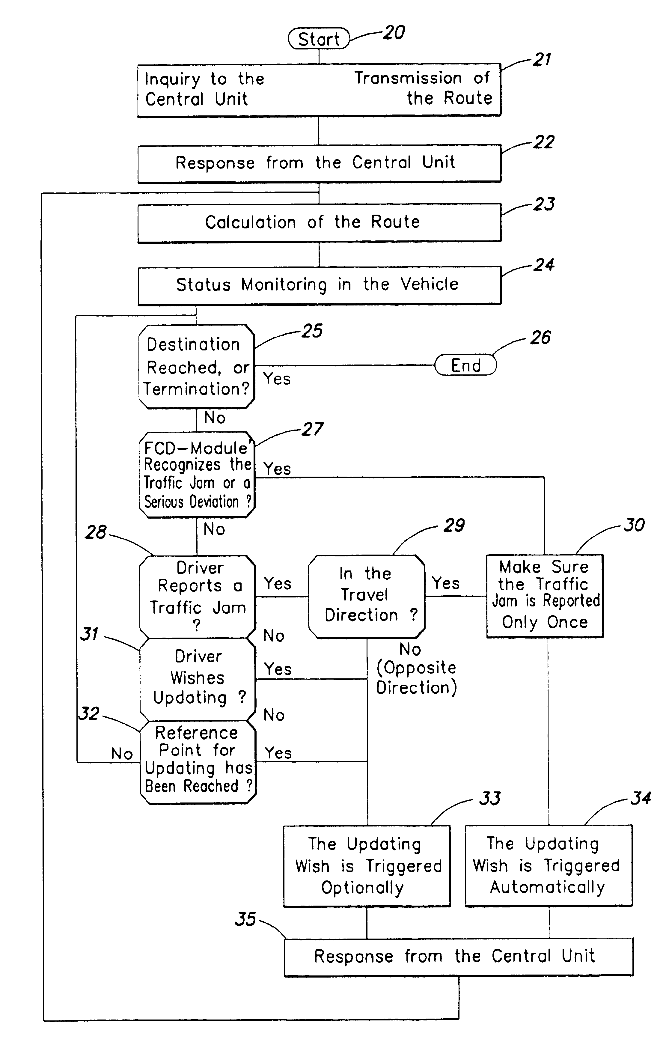
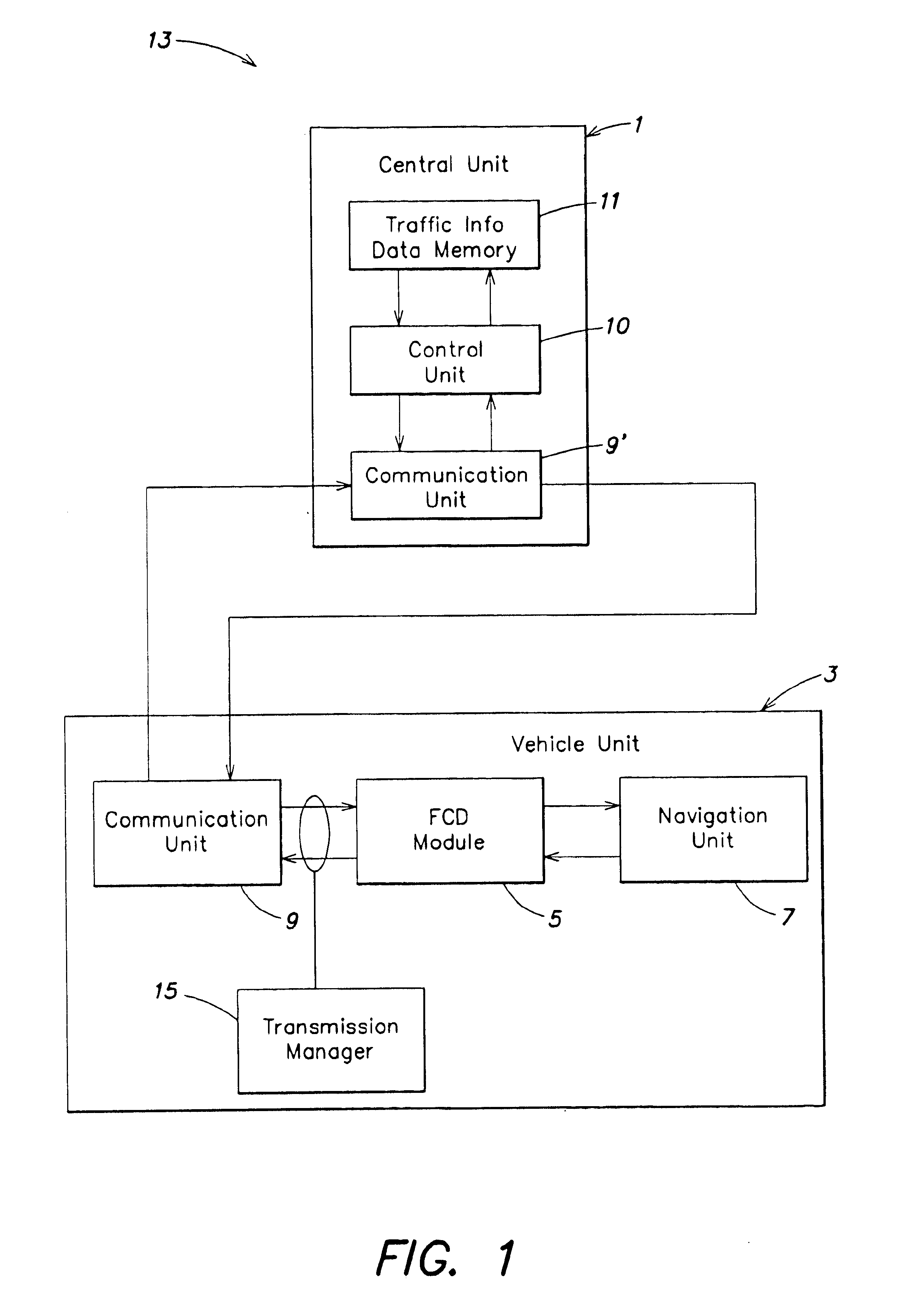
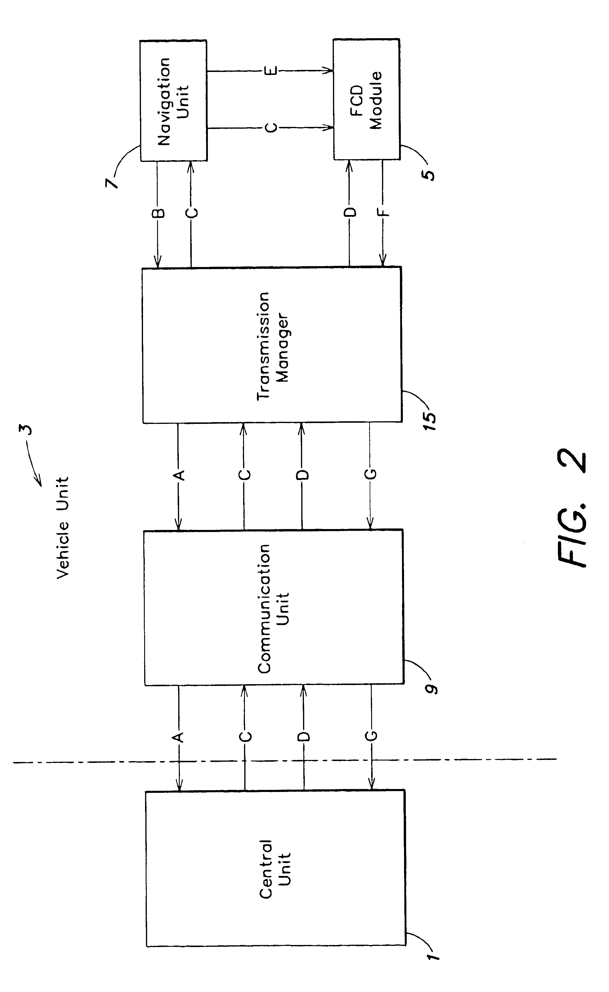
FIG. 1 illustrates a block diagram of an inventive route calculation system 13. The system includes a central unit 1, whose location preferably is fixed, and a vehicle unit 3 situated in a vehicle.

The central unit 1 includes a traffic information data memory 11, and a control unit 10 that is responsible for selecting the traffic information relevant to the requested routes, the choice of reference points for new automatic inquiries, and the interpretation and analysis of the received information. The central unit 1 also includes a communication unit 9′ to transmit and receive data. The traffic information data memory 11 is connected to the control unit 10 through a bidirectional connection, and the control unit 10 is also connected to the communication unit 9′ through a bidirectional connection.

A vehicle unit 3 includes a communication unit 9 to transmit and receive data, a floating car data (FCD) module 5, a navigation unit 7, and a transmission manager 15. In this example, the com...


PUM


Abstract

Data indicative of an instantaneous location, a destination and a route from the instantaneous location to the destination are transmitted from a motor vehicle navigation unit to a central unit. Traffic information about the route between the instantaneous location and the destination are transmitted from the control unit to the vehicle unit. The received traffic information data are used by the vehicle unit to determine a desirable route between the instantaneous location and the destination given the traffic information. The data of the route thus determined are made available to the vehicle driver, so that he is able to steer toward his desired destination along this specified route.

Description

BACKGROUND OF THE INVENTIONThe present invention relates to the field of motor vehicle navigation systems, and in particular to a technique for determining a route between the instantaneous location of the motor vehicle and the destination of the motor vehicle.Known motor vehicle navigation systems often include centrally stored traffic information indicative of a traffic network. This information is retrieved by a vehicle, according to certain criteria, in order to determine the vehicle's optimum route to its destination. A problem with this technique is that the centrally stored traffic information is often insufficient in quantity and quality to properly determine the vehicle's optimum route.One proposed technique for reducing this problem is to receive traffic information (i.e., floating car data) from moving vehicles to supplement the centrally stored traffic information. This technique is premised on the idea that the vehicles themselves recognize traffic conditions and report...

Claims


Application Information

Patent Timeline
Patent Type & Authority Patents(United States)
IPC IPC(8): G01C21/34G08G1/0968G01C21/00G08G1/137
CPCG01C21/3492G08G1/096844G08G1/096827G08G1/096811
Inventor HUBSCHNEIDER, HANSRUF, MICHAEL
Owner HARMAN BECKER AUTOMOTIVE SYST
Why Eureka
Try Eureka