
GPS signal acquisition based on frequency-domain and time-domain processing

a frequency-domain and time-domain technology, applied in the field of satellite navigation systems, can solve the problems of placing a heavier computational burden on the wireless terminal, and the wireless terminal utilizing a frequency-domain code acquisition scheme takes a longer time to fund its position, so as to achieve faster acquisition of c/a, faster acquisition of gps signals, and faster detection of gps signals

Inactive Publication Date: 2005-07-26
ALCATEL-LUCENT USA INC
View PDF25 Cites 37 Cited by
  • Summary
  • Abstract
  • Description
  • Claims
  • Application Information

AI Technical Summary

Benefits of technology

[0015]An improved code acquisition scheme for faster acquisition of GPS “coarse acquisition” (C / A) codes is proposed. The faster acquisition of C / A codes leads to faster detection of GPS signals, and thereby a wireless terminal may determine its position in a shorter period of time. The proposed scheme is a combination of a time-domain code acquisition scheme and a frequency-domain code acquisition scheme. The proposed scheme utilizes a frequency-domain code acquisition technique to detect one GPS signal and to create a precise timing reference, and then utilizes time-domain code acquisition techniques to detect other GPS signals from the same satellite or other satellites faster. The proposed scheme has the advantage of being able to be used for any wireless communications system without the requirement of maintaining a precise timing reference in the wireless terminals, and without the requirement of heavy computational resources that are usually needed in systems that utilize frequency-domain code acquisition schemes.
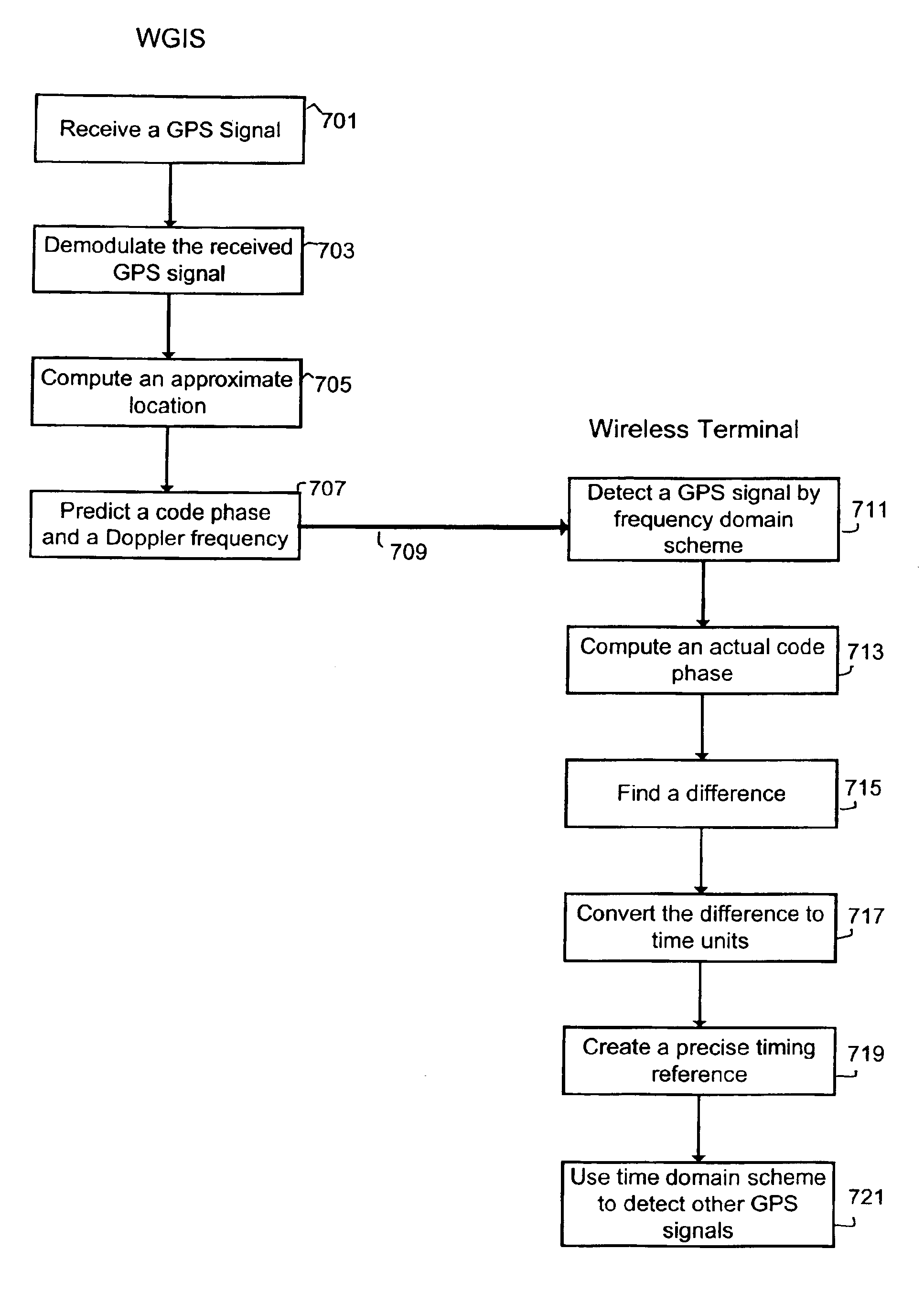
[0017]The wireless terminal detects at least one GPS signal by a conventional code acquisition technique in the frequency domain. The predicted Doppler frequency received from the WGIS helps the detection process by narrowing the frequency search bin. After the detection of a GPS signal from a satellite, the code phase of the GPS signal or the pseudorange from the wireless-terminal to the satellite is measured. The difference between the previously predicted code phase received from the WGIS and the actual measured code phase is then calculated. The difference between the code phases is then converted into time units based on the known GPS signal frequency. For example, 1023 chips of code phase equals 1 ms of time. A precise timing reference is then established by adjusting the time reference of the wireless terminal by the calculated time units.
[0018]The wireless terminal may then use the precise timing reference to apply time-domain code acquisition techniques to detect other GPS signals from the same satellite or other satellites in a relatively short time. These other GPS signals may be previously stored GPS signals or subsequent GPS signals. Generally, the WGIS provides the wireless terminal with satellite Doppler frequencies having an error less than 50 Hz. As such, the wireless terminal need no longer to try all possible frequency steps in the code acquisition process. The acquisition time is reduced by being proportional to the actual number of code-phase searching steps. Furthermore, the WGIS provides the wireless terminal with the satellite's code phase information, and, thus the wireless terminal only needs to search within the possible code phases defined by the timing accuracy. Therefore, the wireless terminal has the advantages of faster code acquisition and lower computational requirements. For example, if the wireless terminal has established a precise local timing reference accurate to the level of a few microseconds, the wireless terminal needs to search GPS signals in only a few code phase chips and thereby wireless terminal may acquire subsequent GPS signals in a relatively short period of time.

Problems solved by technology

A pseudorandom noise code sequence is a series of numbers that is random in the sense that knowledge of which numbers have already been received does not provide assistance in predicting the next received number.
The frequency-domain code acquisition scheme however does not rely on the satellite code phase information and thus places a heavier computational burden on the wireless terminal than the time-domain code acquisition approach.
Furthermore, the wireless terminal utilizing a frequency-domain code acquisition scheme takes a longer time to fund its position.

Method used


Image

  • GPS signal acquisition based on frequency-domain and time-domain processing
  • GPS signal acquisition based on frequency-domain and time-domain processing
  • GPS signal acquisition based on frequency-domain and time-domain processing

Examples


Embodiment Construction

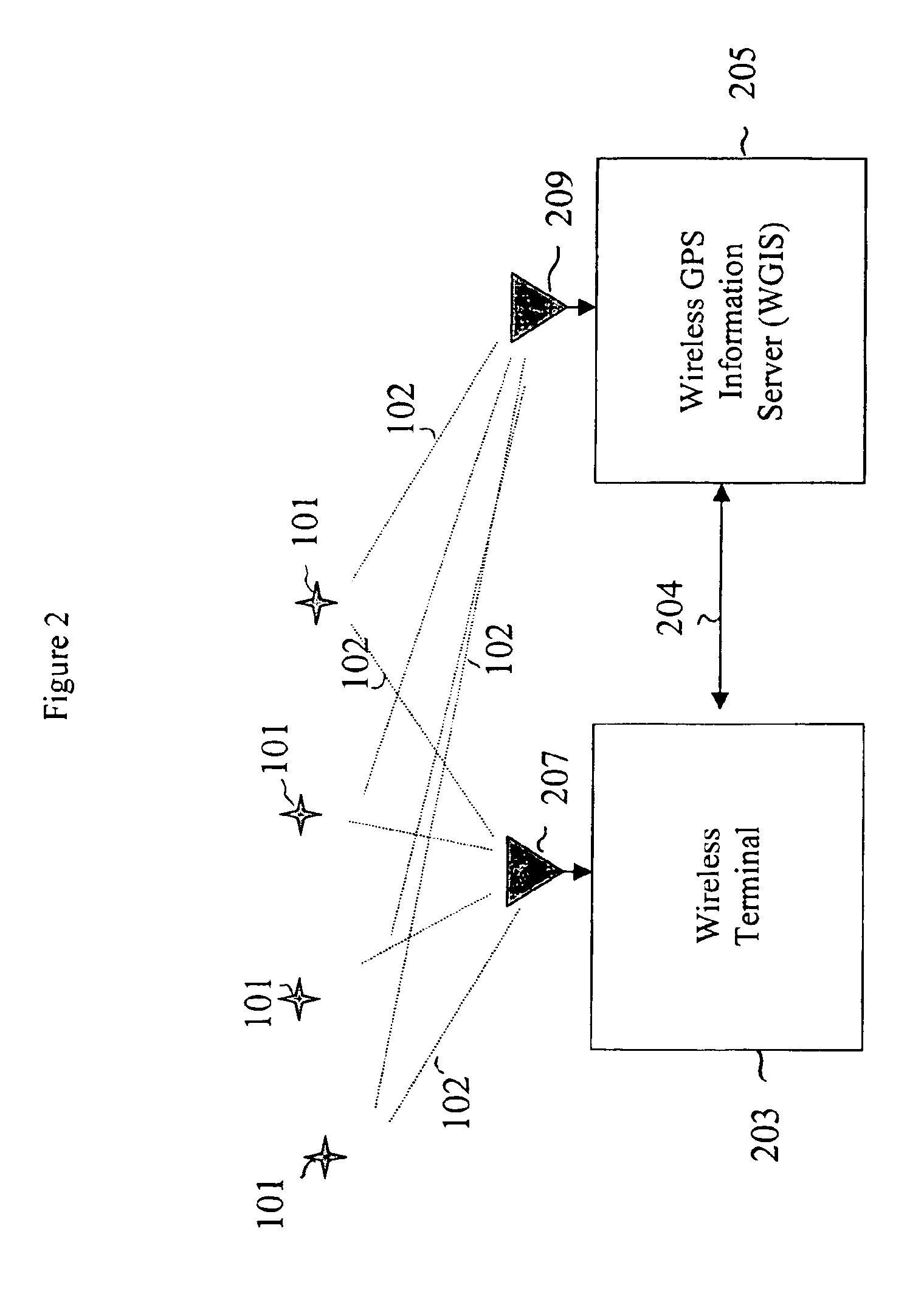
[0029]FIG. 2 illustrates a wireless satellite navigation system 200 in accordance with an illustrative embodiment of the present invention. Wireless satellite navigation system 200 comprises a conventional satellite constellation (i.e., a plurality of GPS satellites 101), a wireless terminal 203, and a wireless GPS information server (WGIS) server 205. Satellite constellation 101 is preferably the GPS system, which is well known in the art. Those skilled in the art will understand how to implement the present invention in the context of satellite navigation systems other than the GPS system.

[0030]WGIS 205 communicates with wireless terminal 203 via a telecommunications link 204, which may be a wireless link or a land-line link. One goal of the illustrative embodiment is to create a precise timing reference so that time-domain code-acquisition processing may be applied in systems where wireless terminals do not otherwise maintain precise timing references.

[0031]In accordance with the...


PUM


Abstract

An improved code acquisition scheme for faster acquisition of GPS “coarse acquisition” (C / A) codes leads to faster detection of GPS signals, and thereby a wireless terminal may determine its position in a shorter period of time. The scheme is a combination of a frequency-domain and time-domain code acquisition techniques. The scheme utilizes a frequency-domain code acquisition technique to detect one GPS signal and to create a precise timing reference at the wireless terminal, and then utilizes time-domain code acquisition techniques to detect other GPS signals from the same satellite or other satellites faster. The scheme has the advantage of being able to be used for any wireless communications system without the requirement of maintaining a precise timing reference in the wireless terminals, and without the requirement of heavy computational resources that are usually needed in systems that utilize frequency-domain code acquisition techniques.

Description

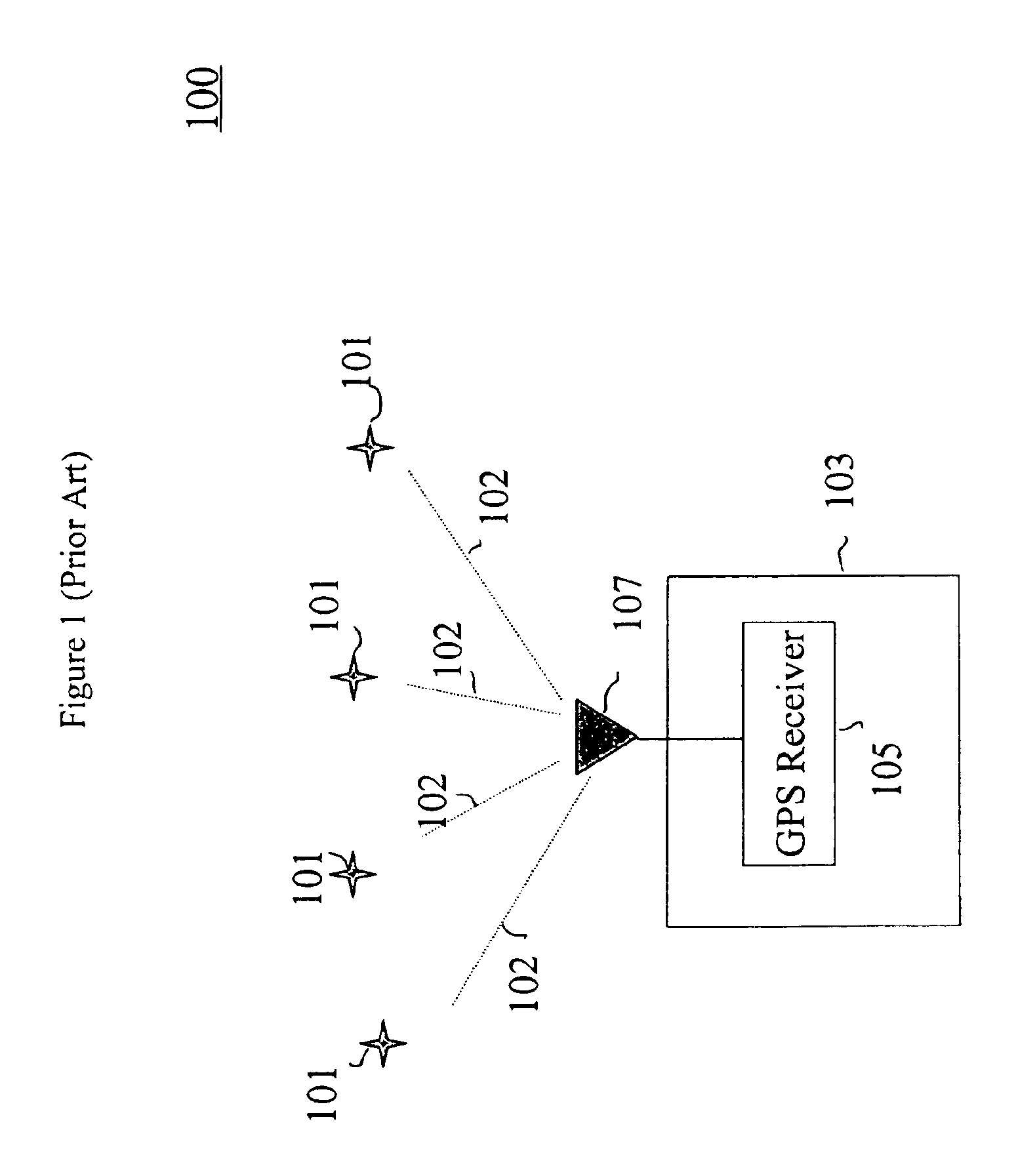
CROSS-REFERENCE TO RELATED APPLICATIONS[0001]The subject matter of this application is related to U.S. patent application Ser. No. 08 / 927,432 filed Sep. 11, 1997 and to U.S. patent application Ser. No. 08 / 927,434 filed Sep. 11, 1997, the teachings of both of which are incorporated herein by reference.BACKGROUND OF THE INVENTION[0002]1. Field of the Invention[0003]The present invention relates to satellite navigation systems, and, more particularly, to satellite navigation systems employing wireless communications technology to enhance signal-detection sensitivity.[0004]2. Description of the Related Art[0005]A satellite navigation system, such as the Global Positioning System (GPS), comprises a constellation of satellites that transmit GPS signals that can be used by a wireless terminal to determine the wireless terminal's position. The orbits of the satellites are arranged in multiple planes in order that signals can be received from at least four satellites at any position on earth...

Claims


Application Information

Patent Timeline
Patent Type & Authority Patents(United States)
IPC IPC(8): G01S1/00G01S19/06G01S19/25
CPCG01S19/06G01S19/254G01S19/256G01S19/235G01S19/24G01S19/30
Inventor DA, RENVANNUCCI, GIOVANNI
Owner ALCATEL-LUCENT USA INC
Learn More