Geophysical method and apparatus

a geophysical method and a technology of towed streamers, applied in the direction of instruments, sonic/ultrasonic/infrasonic transmission, transmission, etc., can solve the problems of unable to economically anchor geophones in marine applications, unable to collect seismic data with towed streamers in areas populated with numerous obstacles, and unable to meet the needs of drilling and production platforms, etc., and achieves a cost-effective and high-efficiency loss

Active Publication Date: 2005-12-13
BP CORP NORTH AMERICA INC
View PDF9 Cites 94 Cited by
  • Summary
  • Abstract
  • Description
  • Claims
  • Application Information

AI Technical Summary

Benefits of technology

[0024]In accordance with the present invention, a method and apparatus is disclosed for performing seismic survey on the seabed. In one embodiment, the method of the invention is performed by first loading several autonomous ocean bottom seismic data receivers in a cage-like carrier located on the deck of a ship on the surface of the water. Each of the receivers has a memory for recording the vibrations of the seabed and has a switch for remotely activating the memory. Next, the carrier is lowered into the water and placed at a depth relatively close to the seabed. A miniature submarine or remotely operated vehicle (ROV) is used to unload the receivers from the carrier and to deposit each receiver on the seabed and its seismic sensor along a survey line. After the seismic sensors are positioned, a source of sound energy is placed in the water, and a signal is transmitted into the water to operate a switch in the data receivers to activate the memories to begin recording, through the sensor, the response of the seabed to the source. In one embodiment, the receiver units comprise a frame, pressure vessels for housing the memory, a sensor connected by a cable to the memory, controls and a power supply, and a coupling for connecting to an arm extending from a ROV.

Problems solved by technology

While geophones are typically used in land operations where metal spikes anchor the geophones to the ground to ensure fidelity of geophone motion to ground motion, geophones cannot be economically anchored in marine applications.
For instance, gathering seismic data with a towed streamer in areas populated with numerous obstacles, such as drilling and production platforms, can be difficult or even impossible because the streamer may strike one of the obstacles and tear loose from the towing vessel.
Such an event represents an extremely costly loss.
In the case of dedicated vessel deployment, such as an RSV, significant costs are associated with operation of a fully founded marine vessel and its mobilization to and from the ROV work site.
Typically, a dedicated RSV may have a crew of twenty and a considerable cost not directly related to the operation of the ROV.
Moreover, the power supply of the ROV is limited.
Clearly, work on the seafloor at deep depths means more expense overall.
This problem has existed for some time.
Considerable effort has been made, and significant amounts of money have been expended, to resolve this problem.
In spite of this, the problem still exists.
Actually, the problem has become aggravated with the passage of time because oil and gas are now being found in deeper and deeper parts of the world's oceans.

Method used


Image

  • Geophysical method and apparatus
  • Geophysical method and apparatus
  • Geophysical method and apparatus

Examples


Embodiment Construction

[0035]While this invention is susceptible of embodiment in many different forms, there is shown in the drawings, and will herein be described in detail, several specific embodiments of the invention. It should be understood, however, that the present disclosure is to be considered an exemplification of the principles of the invention and is not intended to limit the invention to any specific embodiment so described.

[0036]Before describing the invention in detail, the environment of the invention will be explained.

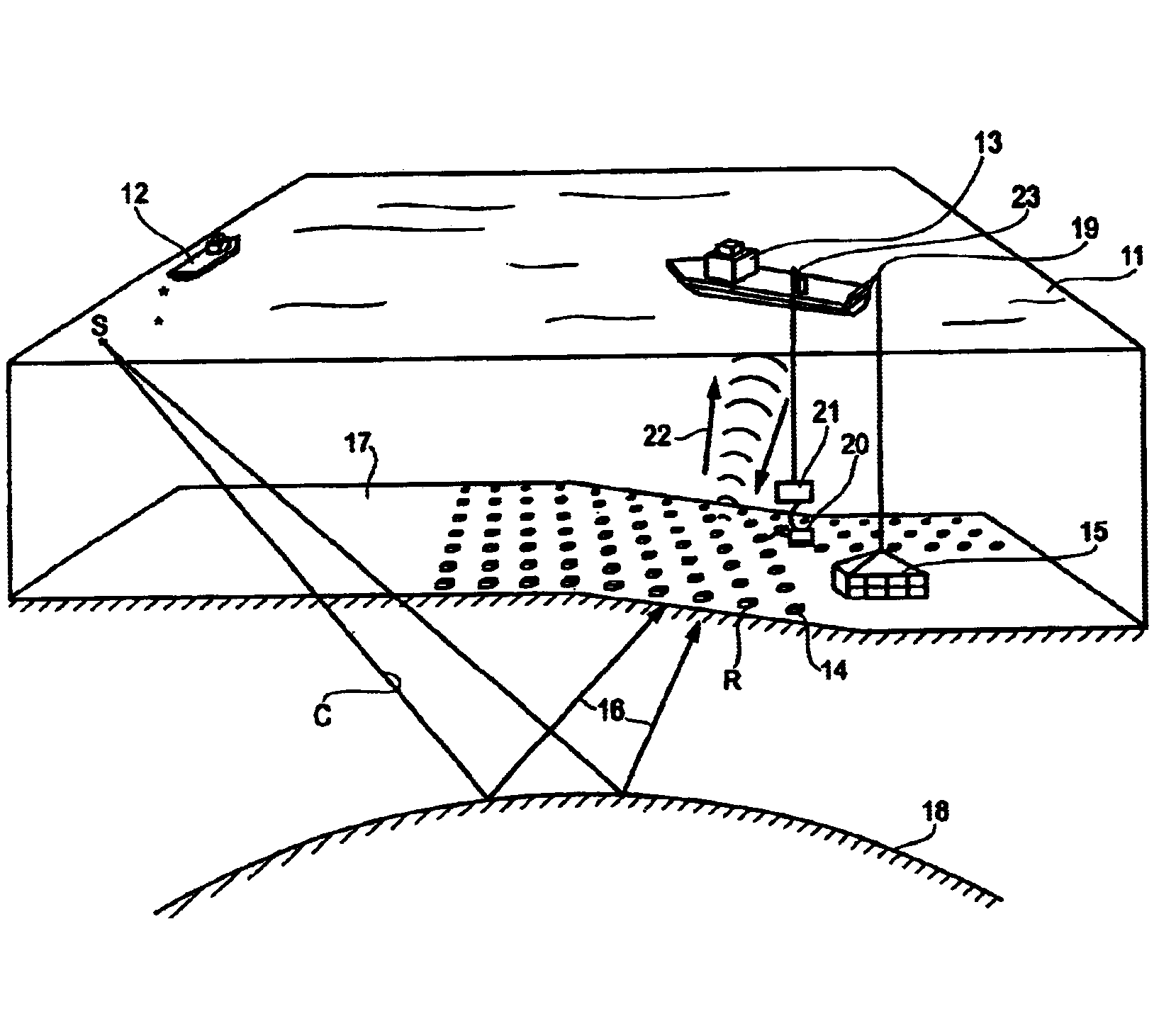
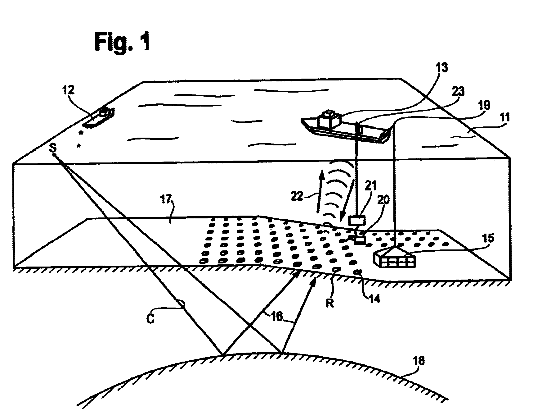
[0037]A. Surface Vessels

[0038]Two or three vessels (see FIG. 1) can be used in the operation, depending on the number of seismic receiver units needed for the survey. Three different options, with regard to a number of vessels in operation, are suggested.

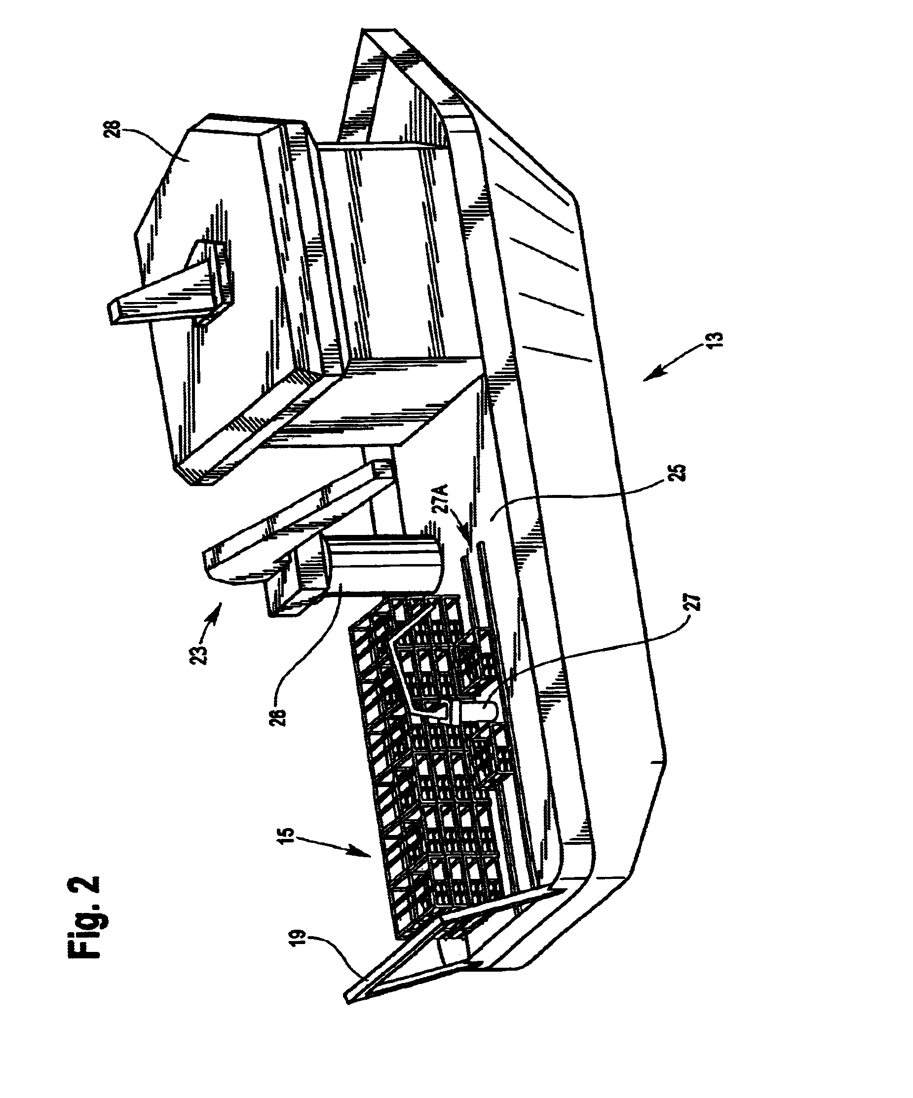
[0039]With a three vessel operation, two receiver handling vessels 13 and one source vessel 12, there will be sufficient time for one of the handling vessels to perform quality control (QC) on the receiver units during oper...


PUM


Abstract

A method and apparatus is disclosed for performing a seismic survey below the surface of a body of water and on the seabed. In one embodiment, a plurality of seismic data receivers are removably loaded in a carrier located above the surface of the water and the carrier is lowered into the water and placed at a depth relatively close to the seabed. Each of the receivers has a memory for recording the vibrations of the seabed and has a switch for activating the memory. A ROV is used to unload the receivers from the carrier and to deposit each receiver on the seabed and along a survey line. In one embodiment, the receivers comprise a frame, a pressure vessel for housing the memory and remotely activated controls, and a geophone that is separately planted into the seabed at a relatively short distance from the frame.

Description

CROSS-REFERENCE TO RELATED APPLICATIONS[0001]This application claims the benefit of the filing date of U.S. Provisional Patent Application Ser. No. 60 / 367,817 filed on Mar. 27, 2002 which disclosure is incorporated herein by reference.TECHNICAL FIELD[0002]This invention relates to the general subject of methods and apparatus used to explore for oil and gas and, in particular, to methods using equipment that is deposited on the seabed to record seismic data.STATEMENT REGARDING FEDERALLY-SPONSORED RESEARCH OR DEVELOPMENT[0003]Not applicableREFERENCE TO A “MICROFICHE APPENDIX”[0004]Not applicableBACKGROUND OF THE INVENTION[0005]Offshore oil production has only moved into the very deep waters in recent years. Most seismic surveys in deep water have been carried out with seismic cables towed behind a vessel of opportunity. Newer seismic techniques lay relatively short cables on the sea floor having a total length of only 3 to 6 kilometers. Some seismic techniques require permanently inst...

Claims


Application Information

Patent Timeline
Patent Type & Authority Patents(United States)
IPC IPC(8): G01V1/38
CPCG01V1/3852
Inventor BERG, EIVIND W.MICHELL, SCOTT T.PURNELL, NIGEL P.OPENSHAW, GRAHAMFYHN, ATLE H.BEAUDOIN, GERARD J.
Owner BP CORP NORTH AMERICA INC
Why Eureka
Try Eureka