Hybrid inertial navigation system with improved integrity

a technology of hybrid inertial navigation and integrity, applied in navigation instruments, instruments, transmission, etc., can solve the problems of difficult problems, insufficient accuracy and reliability of hybrid inertial platforms corrected by satellite based positioning receivers, and insufficient positioning and speed measurements, etc., to achieve the effect of measuring the accuracy of hybrid position determination

Inactive Publication Date: 2006-01-03
THALES SA
View PDF6 Cites 64 Cited by
  • Summary
  • Abstract
  • Description
  • Claims
  • Application Information

AI Technical Summary

Benefits of technology

[0023]The resetting of the inertial platform is therefore done by regularly observing the alterations in the phase of the carrier on each channel of the receiver, these alterations having the characteristic of hardly being affected by noise, and this will make it possible not only to obtain an accurate hybrid po...

Problems solved by technology

The hybridization of the two systems, inertial system and satellite based positioning system, to improve the quality of the position and speed measurements, poses difficult problems.
However,...

Method used


Image

  • Hybrid inertial navigation system with improved integrity
  • Hybrid inertial navigation system with improved integrity
  • Hybrid inertial navigation system with improved integrity

Examples


Embodiment Construction

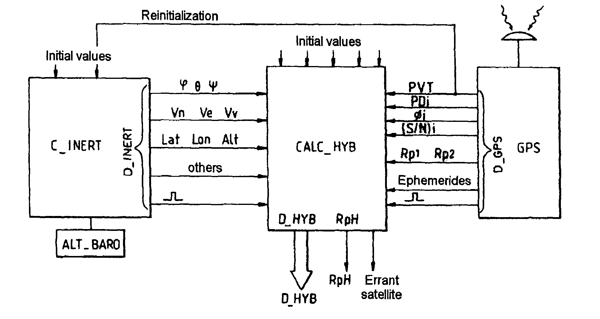
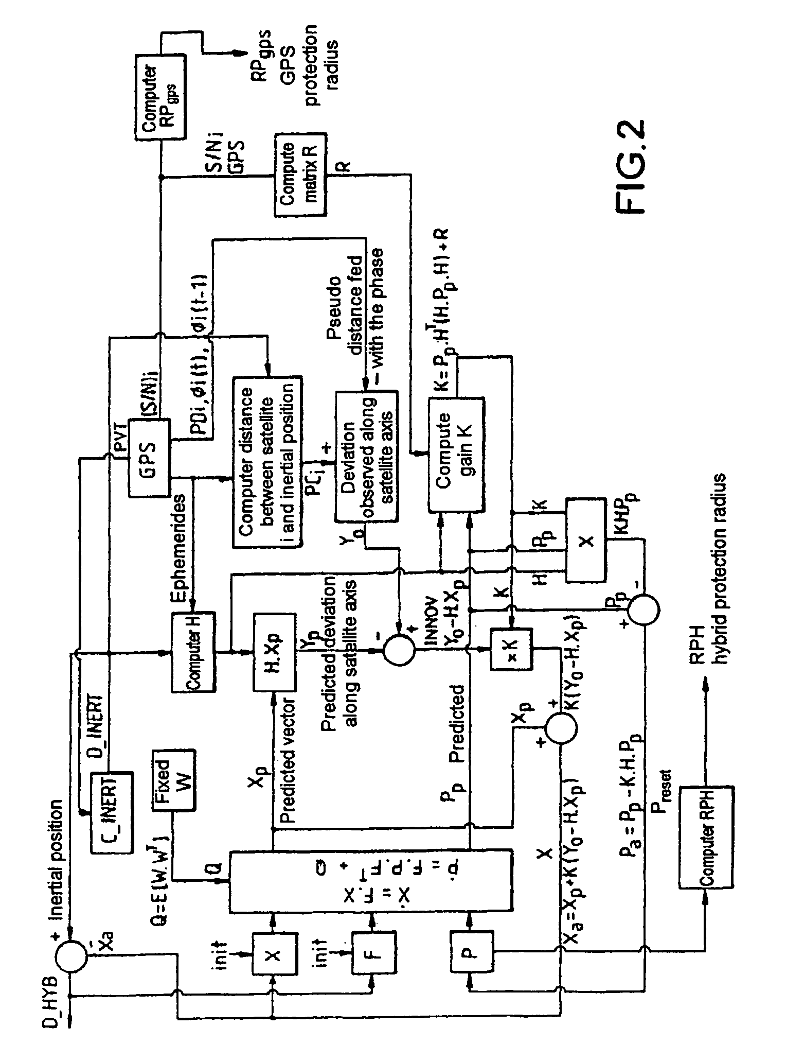
[0031]The hybridized inertial platform comprises an inertial platform proper C—INERT, a satellite based positioning receiver, that will be referred to subsequently as the GPS receiver with reference to the most common positioning system known as “Global Positioning System”, and a hybridization electronic computer CALC—HYB.

[0032]The inertial platform C—INERT is usually composed of[0033]several accelerometers, typically three, with fixed orientations with respect to the aircraft, providing values of acceleration along these axes;[0034]several gyrometers, typically three, each having a fixed axis with respect to the airplane and providing values of speed of angular rotation about these axes,[0035]a computer which determines digital data relating to geographical position (Lat, Lon, Alt), geographical speed (Vn, Ve, Vv), heading roll and pitch attitudes (φ, θ, ψ), etc., on the basis of the indications provided by the accelerometers and gyrometers; the computer also provides a temporal ma...


PUM


Abstract

The invention relates to an internal platform hybridized with a GPS receiver. The hybridization is achieved through a Kalman filter through which a new hybrid position D-HYB is estimated on the basis of a noted deviation between pseudo-distance measure by the receiver between the receiver and the various satellites and corresponding distances computed by the inertial platform between the platform and the same satellites. In this filtering, the distance increment from one measurement instant to the next instant, between the pseudo-distance previously measured by the receiver on a satellite axis of a deviation and the new pseudo-distance measured by the receiver on a satellite axis of a deviation and the new pseudo-distance measured by the receiver on this axis, is the phase variation ΔΦ=Φ(t)−ΦI (t−1) of a digital oscillator between the two measurement instants, this variation being referred to distance along the satellite axis. The oscillator is that which makes it possible to slave the local carrier frequency in the receiver to the carrier frequency received from the satellite. Application to the measurement of position.

Description

CROSS-REFERENCE TO RELATED APPLICATIONS[0001]The present Application is based on International Application No. PCT / FR02 / 03258, filed on Sep. 24, 2002, which in turn corresponds to FR 01 / 12546 filed on Sep. 28, 2001, and priority is hereby claimed under 35 USC §119 based on these applications. Each of these applications are hereby incorporated by reference in their entirety into the present application.FIELD OF THE INVENTION[0002]The invention relates to instruments for aiding navigation and piloting, and in particular to those which are intended for aerial navigation in which the constraints regarding accuracy in position and speed are high and in which the integrity of the information given by the position and speed measuring instruments must be ascertained at every moment.[0003]The use of inertial navigation platforms in aircraft is very conventional today. These platforms use accelerometers to determine accelerations along axes defined with respect to the aircraft, gyrometers to ...

Claims


Application Information

Patent Timeline
IPC IPC(8): H04B7/185G01S19/23G01C21/16G01S5/14G01S19/47
CPCG01S19/47G01C21/165G01S19/20
Inventor COATANTIEC, JACQUESGUILLARD, PATRICE
Owner THALES SA
Why Eureka
Try Eureka