

Map-data distribution method, and map-data distribution server and client
a technology of map data and server, applied in the direction of using reradiation, navigation instruments, instruments, etc., can solve the problems requiring a large amount of time for the client to draw the map image, and requiring a long time for the transmission of the map image, so as to achieve the effect of reducing the communication time between the server and the clien
- Summary
- Abstract
- Description
- Claims
- Application Information
AI Technical Summary
Benefits of technology
Problems solved by technology
Method used
Image

Examples
first embodiment
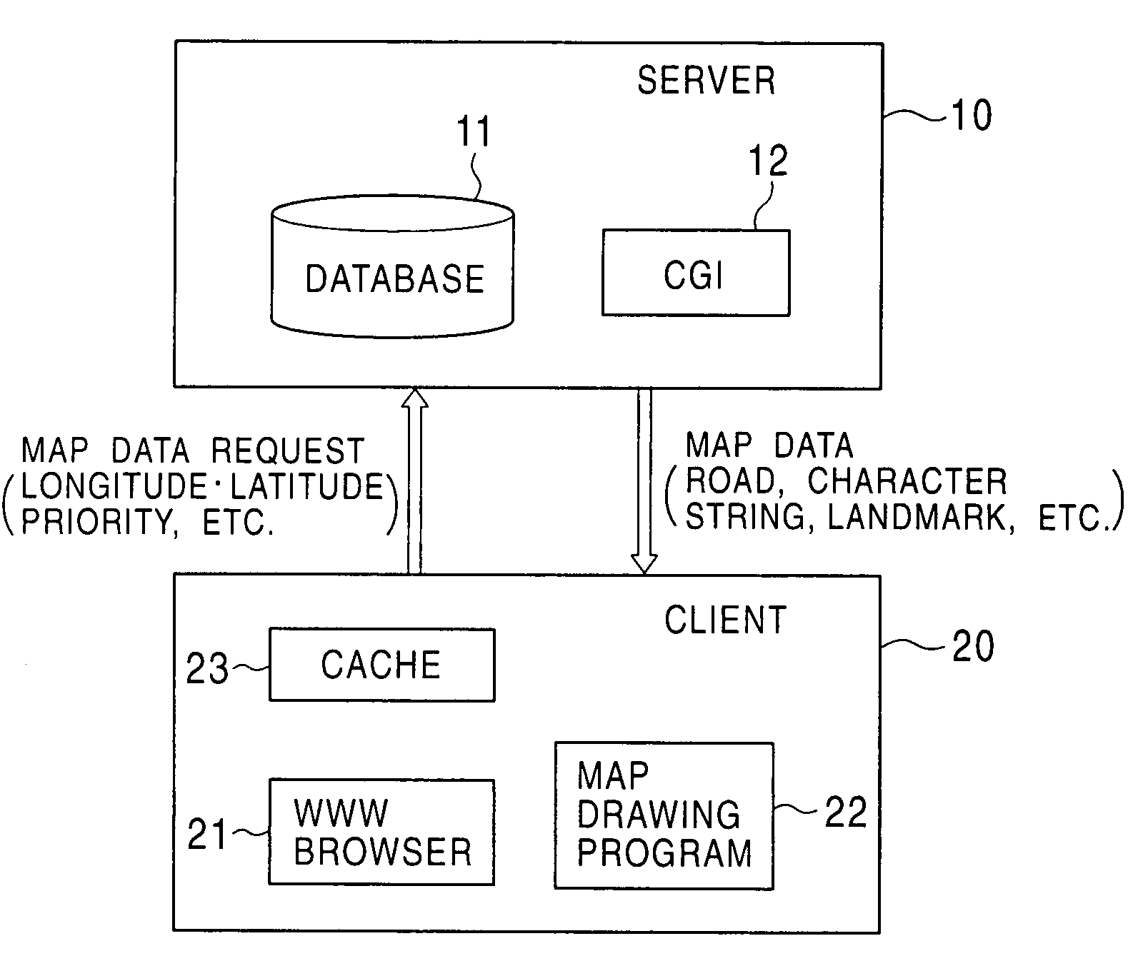
[0025]FIG. 1 shows the construction of a system for realizing a map-data distribution method according to the first embodiment of the invention. The system includes a map-data distribution server 10 and a client 20 which are connected via a communication line such as the Internet.
[0026]The map-data distribution server 10 includes a map database 11 for storing map data therein and a CGI (Common Gateway Interface) 12 for extracting predetermined image data from the map database 11.
[0027]Map data stored in the map database 11 is divided into segments, each of which has an appropriate range of longitudes and an appropriate range of latitudes in accordance with a map scale such as 1:12500, 1:25000, 1:50000, or 1:100000. For example, roads are represented by links among a plurality of nodes (vertexes) and are stored as a set of the nodes represented by the longitudes and the latitudes of the corresponding nodes. The map data includes the following data: (1) road data used for drawing road...
second embodiment
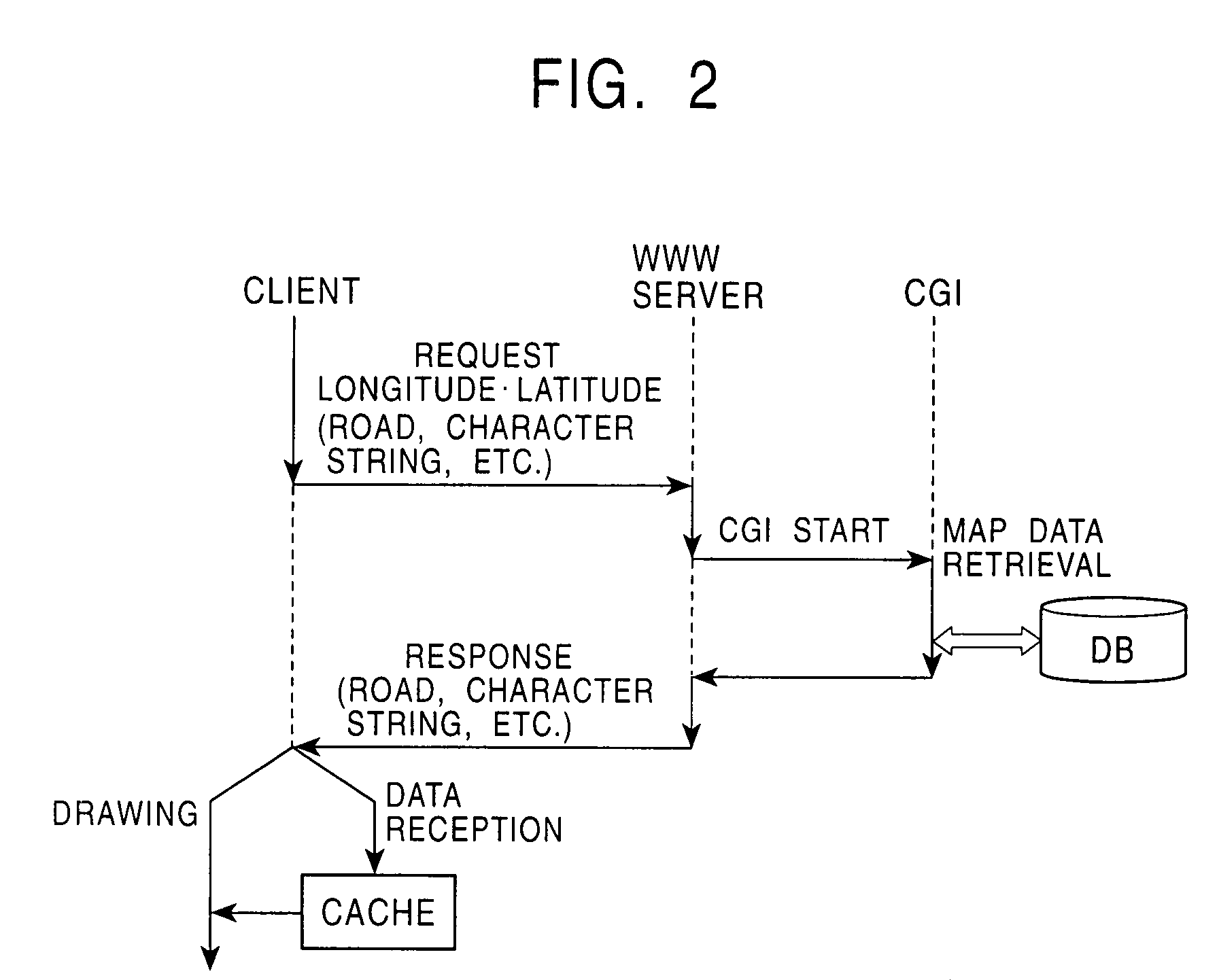
[0039]FIG. 3 shows the construction of a system for realizing a map-data distribution method according to the second embodiment of the invention. The system includes a map-data distribution server 30 and a client 40.
[0040]The map-data distribution server 30 includes a map database (DB) 31 for storing the map data therein, a CGI or a Servlet 32 (referred to as the CGI / Servlet 32) for extracting predetermined map data from the map database 31, and a WWW server 33. In the same manner as in the first embodiment, the map database 31 contains the map data which are classified by the map components such as the road data, the polygon data, the character string data, and the landmark data in accordance with the map scales. The WWW server 33 can be accessed from the Internet and provides the web site. Accordingly, the client 40 can easily access the map-data distribution server 30 using a web browser.
[0041]The CGI / Servlet 32 is activated in accordance with a request from the client 40 which a...
third embodiment
[0066]The third embodiment according to the present invention will now be described. The characteristic feature of the third embodiment is an operation of the map-data retrieval unit 52, and otherwise the basic construction of the present embodiment is identical to that of the second embodiment. Hence, the present embodiment is also described with reference to FIG. 3, and repeated descriptions are omitted.
[0067]In the second embodiment, the drawing unit 55 performs map-image drawing processing in accordance with the map components read from the cache 44 until the drawing queue 56 is empty. However, when a new location is input or when the map scale is changed, it is preferable that the map-image drawing processing, which is currently running, should be cancelled and it should be restarted using the new input data. To implement such an operation, the map-data retrieval unit 52 of the present embodiment performs processing in accordance with the flowchart shown in FIG. 9.
[0068]At step...
PUM
 Abstract
Description
Claims
Application Information