Method for improving GPS integrity and detecting multipath interference using inertial navigation sensors and a network of mobile receivers

a multi-path interference and inertial navigation technology, applied in the field of vehicle navigation using the global positioning system, can solve problems such as receiver errors, receiver errors that cannot be readily cancelled or corrected, and receiver errors that are typically encountered

Inactive Publication Date: 2006-09-19
ROBERT BOSCH GMBH
View PDF11 Cites 29 Cited by
  • Summary
  • Abstract
  • Description
  • Claims
  • Application Information

AI Technical Summary

Problems solved by technology

However, two sources of error which currently cannot be readily canceled or corrected are receiver error, and errors caused by multipath interference.
Receiver errors typically arise from a malfunction in a component of a receiver tuned to a particular GPS satellite and have little correlation with the position of the receiver.
Multipath interference therefore severely limits the achievable accuracy of DGPS.
This renders DGPS unsuitable for applications that demand high accuracy and integrity, and in particular, forbids the use of DGPS for safety relevant applications.

Method used


Image

  • Method for improving GPS integrity and detecting multipath interference using inertial navigation sensors and a network of mobile receivers
  • Method for improving GPS integrity and detecting multipath interference using inertial navigation sensors and a network of mobile receivers
  • Method for improving GPS integrity and detecting multipath interference using inertial navigation sensors and a network of mobile receivers

Examples


Embodiment Construction

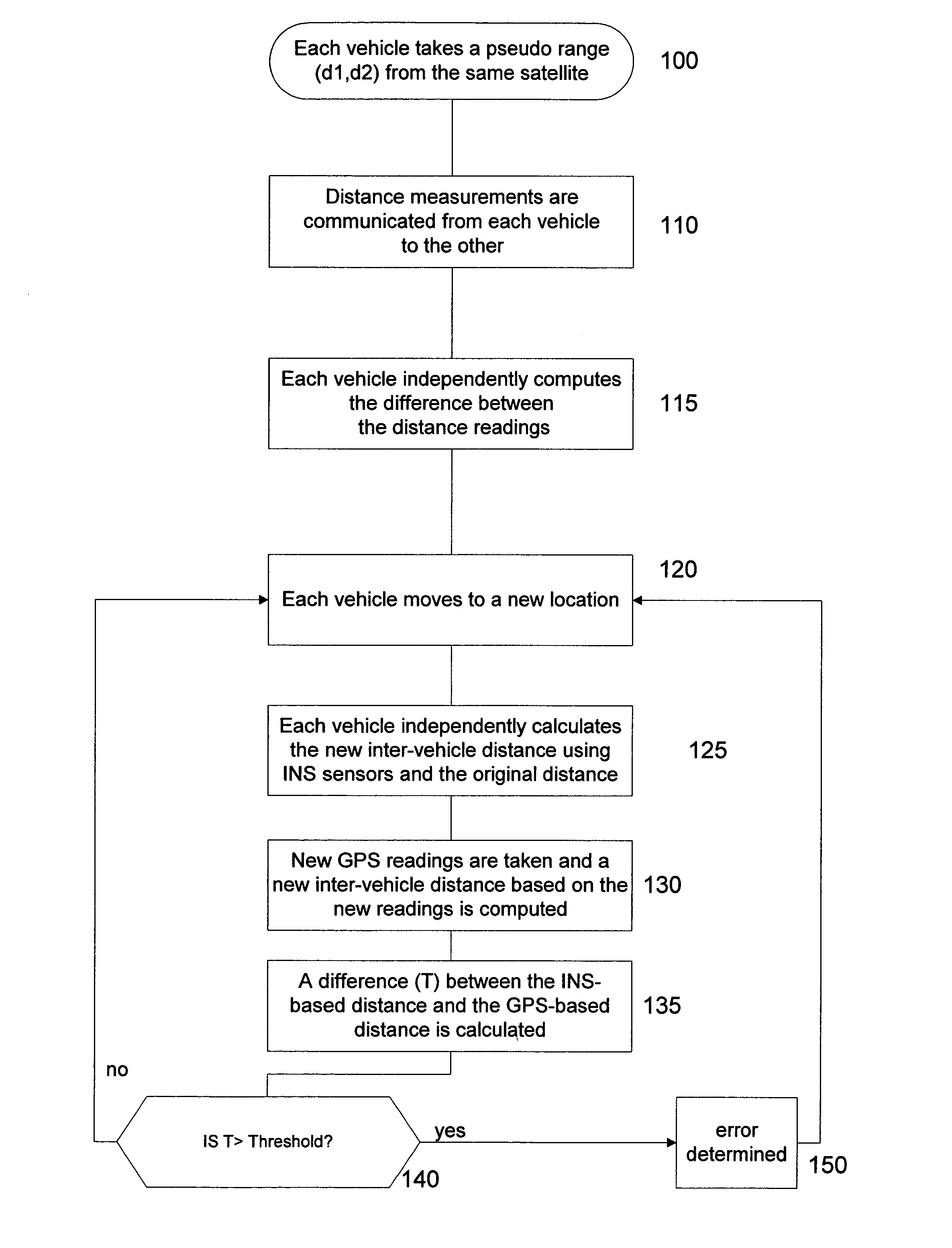
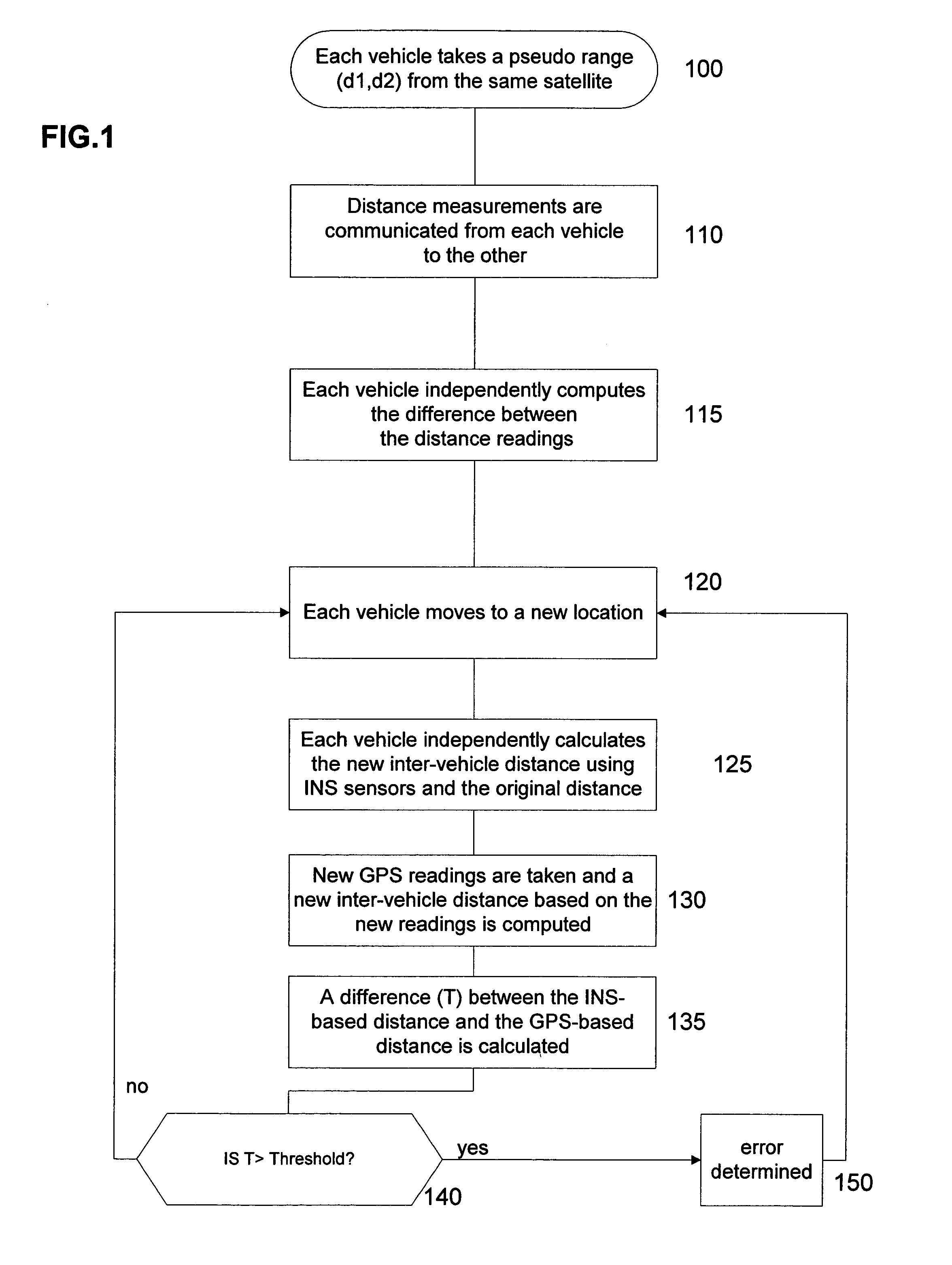
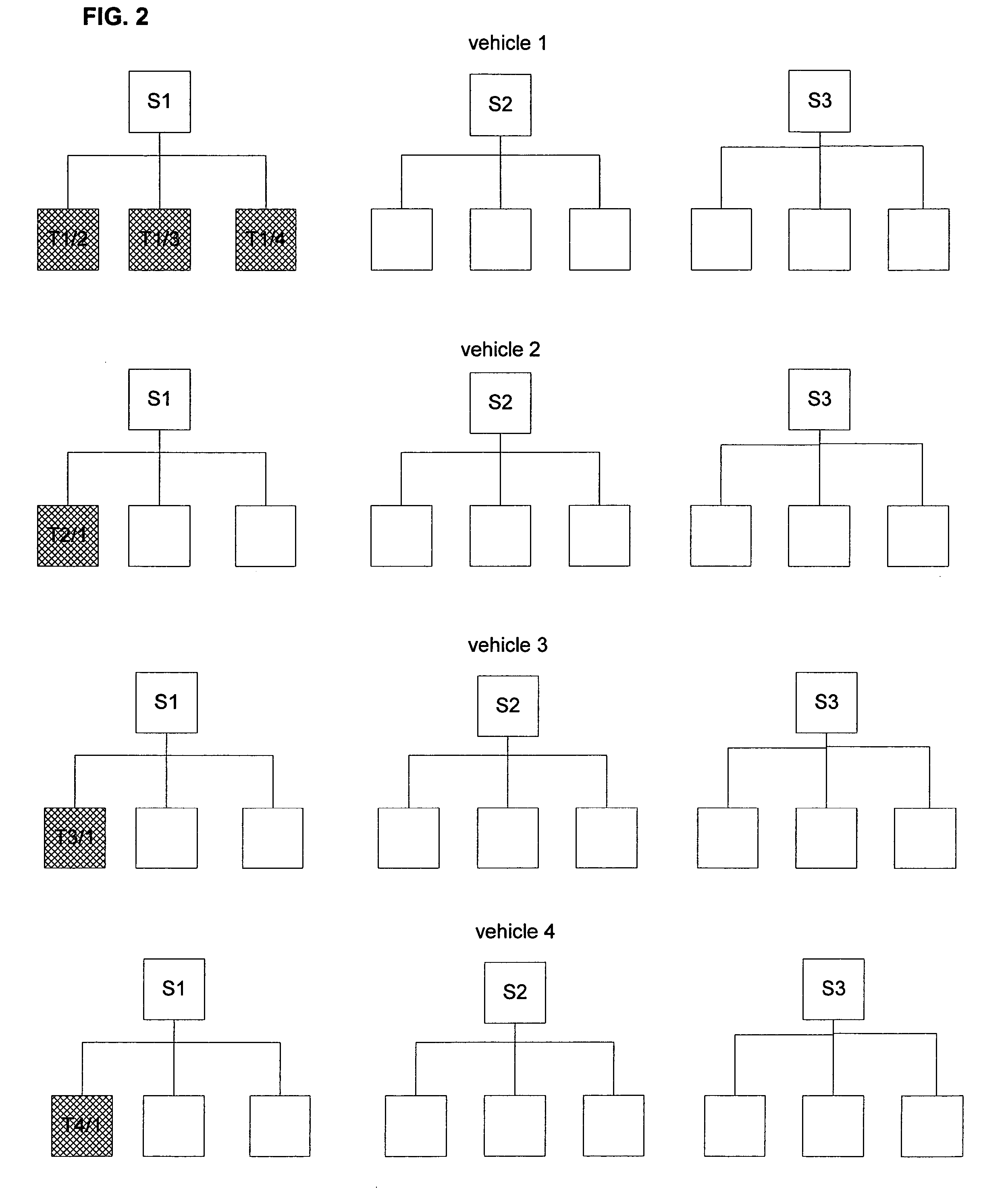
[0016]According to the present invention, in-vehicle navigation systems and inter-vehicle data communication are used to correct for receiver errors and to detect multipath interference (hereinafter referred to as “multipath”). For each pair of vehicles in the same vicinity, a test series of comparison data is generated.

[0017]FIG. 1 is a flow chart of an exemplary method for generating a test series of data for a pair of GPS-enabled vehicles in the same vicinity according to the present invention. Generally, vehicles within one or two kilometers of each other are considered to be in the same vicinity. In an initial step 100, each vehicle takes a pseudorange measurement d1, d2 from the same GPS satellite. In step 110, these measurements are communicated from each vehicle to the other using two-way communication or any other suitable wireless communication system. In step 115, each vehicle computes the difference Δ1 (=d1−d2) between the measurements. As the distance between each vehic...


PUM


Abstract

A method for checking the integrity of GPS measurements for a moving vehicle includes determining a first inter-vehicle distance between a first vehicle and a second vehicle based on GPS measurements obtained at both vehicles, independently determining a second inter-vehicle distance based on relative motion of the first vehicle and the second vehicle obtained using INS sensors at both vehicles, and comparing the first and second inter-vehicle distances. The integrity of the GPS measurements are checked if the first and second inter-vehicle distances are nearly equivalent. Methods for error detection and for mapping GPS multipath levels at each point in a vicinity for an entire range of satellite constellations are also described.

Description

FIELD OF THE INVENTION[0001]The present invention relates to vehicle navigation using the global positioning system (GPS) and more particularly relates to a method for checking the integrity of GPS signals for errors and for detecting GPS multipath interference. The present invention further relates to a method for multipath modeling and correction based on detected levels of multipath interference.BACKGROUND INFORMATION[0002]Generally, most systematic sources of error in differential GPS (DGPS), such as clock error, can be canceled or corrected to a large degree using conventional techniques. However, two sources of error which currently cannot be readily canceled or corrected are receiver error, and errors caused by multipath interference. Receiver errors typically arise from a malfunction in a component of a receiver tuned to a particular GPS satellite and have little correlation with the position of the receiver. In contrast, multipath interference, i.e., the interference caused...

Claims


Application Information

Patent Timeline
Patent Type & Authority Patents(United States)
IPC IPC(8): G01C21/26G01C25/00G01C21/16G01C21/28G01S5/12G01S19/48
CPCG01C21/28G01C21/165G01S19/22G01S19/49G01S19/074
Inventor MOSER, MICHAELDIETRICH, ARNE
Owner ROBERT BOSCH GMBH
Why Eureka
Try Eureka