Made-in-China satellite laser altimeter on-orbit geometric calibration method and system

A laser altimeter and geometric calibration technology, applied in radio wave measurement systems, instruments, etc., can solve the problem of high calibration cost

Active Publication Date: 2016-08-10
SHANGHAI INST OF TECHNICAL PHYSICS - CHINESE ACAD OF SCI
View PDF6 Cites 25 Cited by
  • Summary
  • Abstract
  • Description
  • Claims
  • Application Information

AI Technical Summary

Problems solved by technology

[0005] The purpose of the present invention is to solve the deficiencies in the prior art, and provide a method and system for on-orbit geometric calibration of a domestic satellite laser altimeter. The topographical features irradiated by the satellite laser altimeter on the ground surface are used as calibration constraints, and the least square method is used to calculate the system geometry. Calibration parameters overcome the problem of high cost of satellite laser altimeter on-orbit calibration

Method used


Image

  • Made-in-China satellite laser altimeter on-orbit geometric calibration method and system
  • Made-in-China satellite laser altimeter on-orbit geometric calibration method and system
  • Made-in-China satellite laser altimeter on-orbit geometric calibration method and system

Examples


Embodiment Construction

[0046] The present invention will be further described in detail below with reference to the accompanying drawings in conjunction with specific implementation examples.

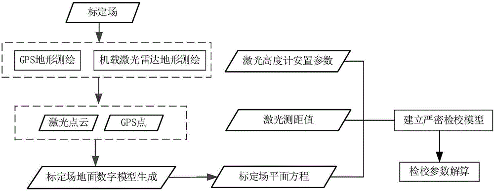
[0047] Such as figure 1 As shown, the present invention provides a method for on-orbit geometric calibration of a domestic satellite laser altimeter, which includes the following steps:

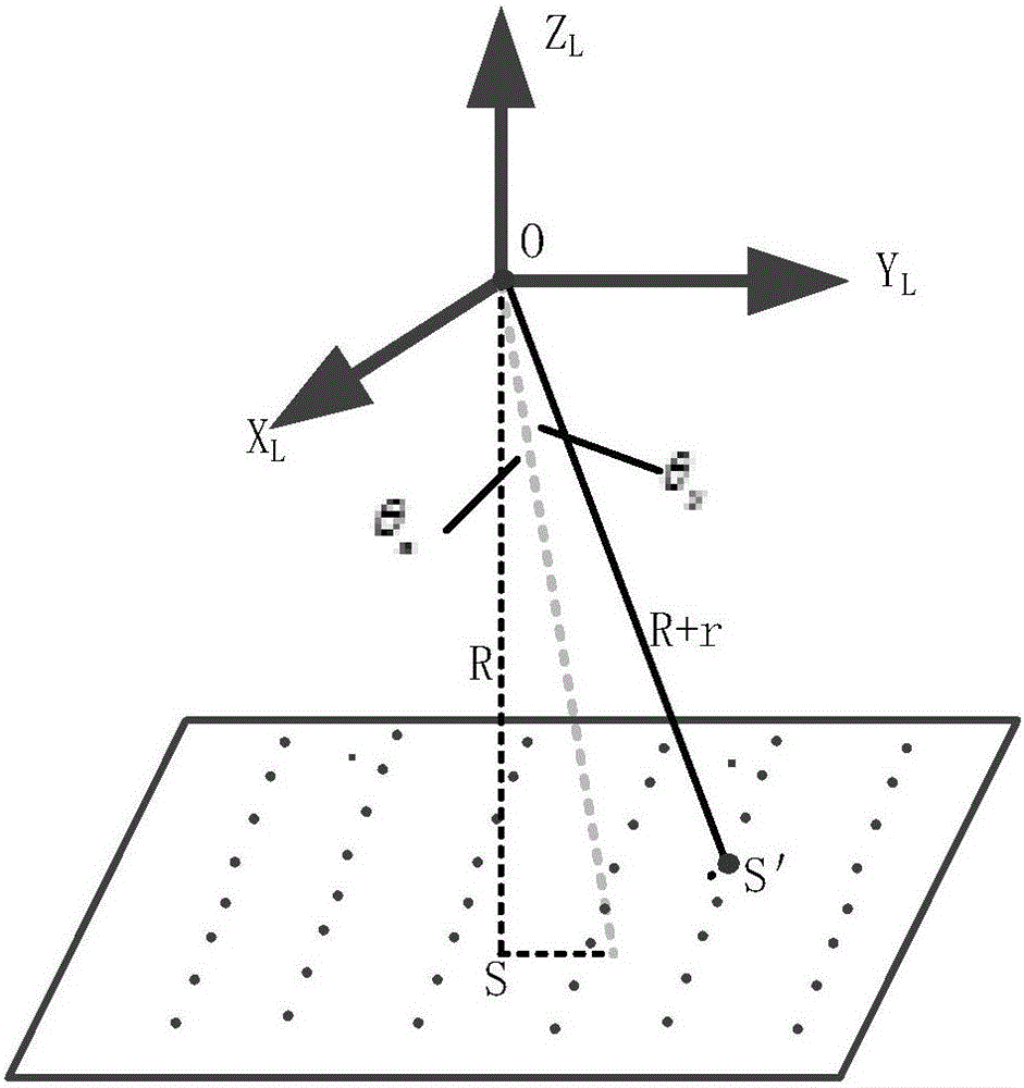
[0048]Step 1.1, for the plane of the calibration field, use airborne laser radar or GPS measurement to obtain high-precision laser point cloud or GPS measurement points, use these discrete points to construct a digital surface model, and establish the plane equation of the calibration area. The step 1.1 includes the following specific steps:

[0049] Step 1.1.1, the terrain data collection of the calibration site. The terrain data collection of the calibration site can adopt two data collection methods: airborne lidar measurement and GPS field measurement. Choose a relatively clear weather, measure the terrain of the calib...


PUM


Abstract

The invention discloses a made-in-China satellite laser altimeter on-orbit geometric calibration method and a made-in-China satellite laser altimeter on-orbit geometric calibration system. The made-in-China satellite laser altimeter on-orbit geometric calibration method comprises the steps of: measuring terrain of a calibration field by utilizing an airborne laser radar or GPS before satellite top-crossing; fitting a surface geometry model of the calibration field by adopting laser radar point clout data or ground GPS measurement data; and placing a laser point of a satellite laser altimeter on a known plane as a constraint condition, establishing a satellite laser altimeter strict geometric calibration model, utilizing a least square principle, and solving a geometric calibration parameter of the satellite laser altimeter. The made-in-China satellite laser altimeter on-orbit geometric calibration method and the made-in-China satellite laser altimeter on-orbit geometric calibration system can effectively solve the problem that positioning precision of a laser spot is not high due to installation deviation of the satellite laser altimeter and errors of laser range finding by utilizing ground natural terrain during satellite transition, increase measuring precision of the made-in-China satellite laser altimeter, and have high applicability and practical value.

Description

technical field [0001] The invention belongs to the technical field of remote sensing and earth observation, and in particular relates to an on-orbit geometric calibration method and system for a domestic satellite laser altimeter. Background technique [0002] Satellite laser altimeter is an active remote sensing technology that installs a laser altimeter on a satellite platform to achieve earth observation. As one of the most important payloads for deep space exploration, it has controllable laser footprint size, precise laser beam pointing and high-precision measurement, etc. Advantages, almost all aerospace projects are equipped with this sensor. However, the measurement accuracy of the laser altimeter for earth observation is affected by many factors, among which laser ranging and laser beam pointing will directly cause the position of the laser spot to shift, and the ranging of the laser altimeter is mainly affected by factors such as the atmosphere and time measuremen...

Claims


Application Information

Patent Timeline
Patent Type & Authority Applications(China)
IPC IPC(8): G01S7/497
CPCG01S7/497
Inventor 蔡银桥邱振戈谢锋舒嵘王建宇
Owner SHANGHAI INST OF TECHNICAL PHYSICS - CHINESE ACAD OF SCI
Why Eureka
Try Eureka