Shallow river water depth surveying and mapping method and system based on unmanned aerial vehicle multi-view shooting

An unmanned aerial vehicle, multi-viewpoint technology, applied in the field of shallow water river depth surveying and mapping, can solve the problems of affecting laser transmission, affecting the wavelength and pulse shape of reflected waves, time and frequency limitations of measurement, etc., and achieves high measurement accuracy and resolution. The effect of improving spatial resolution and reducing personal danger

Active Publication Date: 2020-02-11
INST OF GEODESY & GEOPHYSICS CHINESE ACADEMY OF SCI
View PDF7 Cites 24 Cited by
  • Summary
  • Abstract
  • Description
  • Claims
  • Application Information

AI Technical Summary

Problems solved by technology

However, due to a variety of reasons, depth-sounding radar has not been widely used in water depth surveying and mapping. First, the depth-sounding radar itself is expensive, and one probably costs more than one million. Obviously, this will incur high costs and limit the time and frequency of measurement; secondly, complex environmental factors such as water clarity, vegetation coverage, and water waves on the surface of the water body will affect the laser's accuracy. Transmission, which affects the wavelength and pulse shape of the reflected wave; third, the measurement in shallow water areas is not easy to implement, mainly because it is difficult to distinguish the reflection of the water surface, water body, and bottom

Method used


Image

  • Shallow river water depth surveying and mapping method and system based on unmanned aerial vehicle multi-view shooting
  • Shallow river water depth surveying and mapping method and system based on unmanned aerial vehicle multi-view shooting
  • Shallow river water depth surveying and mapping method and system based on unmanned aerial vehicle multi-view shooting

Examples


specific Embodiment

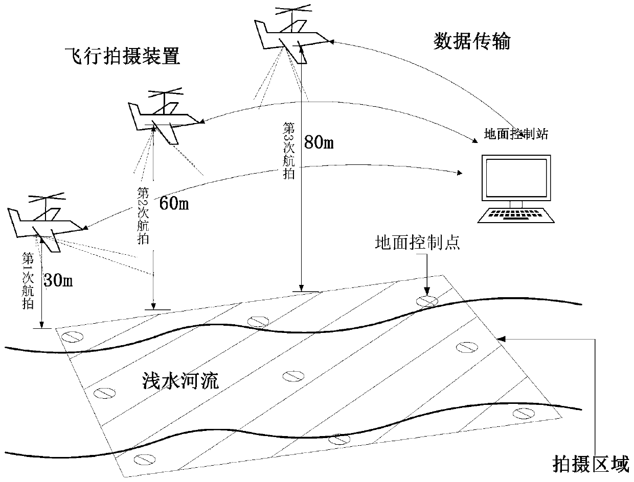
[0096] In this embodiment, a 300m-long, crystal-clear stream section with a maximum water depth of less than 2m is taken as an example to illustrate the specific implementation process. The bathymetric mapping method of shallow water rivers based on UAV multi-viewpoint photography includes the following steps:

[0097] (1) Determine the survey time, survey method and survey precision.

[0098] Choose sunny, cloudless dry season or flat water season to carry out the survey. The survey method chooses the UAV program-controlled operation mode. The survey accuracy is that the resolution of the central pixel of the captured image is not less than 0.1m.

[0099] (2) Layout of ground control points.

[0100] According to the size of the investigation area of ​​the stream section, 9 control points need to be arranged, which are respectively distributed in the four corners of the upstream and downstream and the clear, obvious, and open places in the middle reaches of the river section...


PUM


Abstract

The present invention discloses a shallow river water depth surveying and mapping system and method based on unmanned aerial vehicle multi-view shooting. The method comprises step S1: determining a surveying time, a surveying area and surveying precision; S2: setting ground control points GCPs in the surveying area, and using a positioning instrument to perform positioning on the control points; S3: planning a flight line of an unmanned aerial vehicle, and performing aerial shooting according to the pre-determined air line; and S4: using unmanned aerial vehicle image analysis software to process an image of the multi-view shooting in step S3, surveying an orthoimage and a digital surface elevation model of the area, and applying an optical model water depth inverse program to perform refraction correction and to perform inversion to obtain a water depth value of a shallow river. Compared with conventional GPS measurement, total station measurement and echo sounding, the method is time-saving, labor-saving and cost-saving, causes no damage to a water body and a river bed, and has relative high execution efficiency; and water depth surveying and mapping is extended from point measurement to face measurement, a relatively high spatial resolution is provided, and water depth measurement precision and a spatial resolution are also improved.

Description

technical field [0001] The invention relates to the field of river bathymetry, in particular to a method and system for depth surveying and mapping of shallow water rivers based on multi-viewpoint photography of an unmanned aerial vehicle. Background technique [0002] In large rivers, water depth can be measured with instruments such as sonar (single or multi-beam), bathymetric airborne lidar (light detection and ranging), or acoustic Doppler. However, in shallow rivers or small streams with water depth less than 2m, high-resolution bathymetry is difficult due to side interference. Shallow water rivers are important habitats for various aquatic and terrestrial organisms, and shallow water areas in rivers are of great significance in ecology and geomorphology. However, compared with the traditional deep-water survey, the equipment and methods for shallow-water river survey are very limited. Limited by spatial resolution and accuracy, many bathymetry methods are not suitabl...

Claims


Application Information

Patent Timeline
Patent Type & Authority Applications(China)
IPC IPC(8): G01C13/00G01C11/04
CPCG01C11/04G01C13/008Y02A90/30
Inventor 班璇侯晓璐史建全祁洪芳杜浩凌峰郭舟
Owner INST OF GEODESY & GEOPHYSICS CHINESE ACADEMY OF SCI
Why Eureka
Try Eureka