Methods and systems for measuring terrain height

a technology of height measurement and method, applied in the direction of fluid pressure measurement, instruments, using reradiation, etc., can solve the problems of reducing accuracy and/or resolution, affecting the accuracy of barometric altimeters and gns/sbas receivers, and causing problems such as greater difficulty

Active Publication Date: 2006-12-05
HONEYWELL INT INC
View PDF23 Cites 68 Cited by
  • Summary
  • Abstract
  • Description
  • Claims
  • Application Information

AI Technical Summary

Benefits of technology

[0009]In one aspect, an altitude measuring system is provided that comprises a radar altimeter configured to measure altitude and a digital terrain database. The digital terrain database comprises data relating to terrain elevation and at least one data parameter relating to an accuracy of the terrain elevation data and the altitude measured by the radar altimeter. The system is configured to weigh an altitude derived from the terrain elevation data and the radar altimeter measurements according to the at least one data parameter.
[0010]In another aspect, a method for determining an altitude of an air vehicle is provided. The method comprises measuring an altitude using a radar altimeter, retrieving data from a database relating to an accuracy of at least one of radar altimeter measurements for the location and digital terrain database elevation data for the location, and weighting the altitude as determined by the radar altimeter according to the accuracy data for the location retrieved from the database.
[0011]In still another aspect, a terrain map database comprising map data relating to a number of locations is provided. The map data comprises at least one data field relating to an accuracy for at least one of radar altimeter measurements and digital terrain database elevations for each map location.

Problems solved by technology

Aircraft precision landing systems based on Global Navigation Systems (GNSs) such as the global positioning system (GPS) and Spaced Based Augmentation Systems (SBASs) such as the Wide Area Augmentation System (WAAS), which is a form of differential GPS, generally face a greater challenge for accuracy and integrity of vertical position (i.e., altitude above sea level) measurements than for horizontal position (i.e., latitude and longitude) measurements.
As such, barometric altimeters and GNS / SBAS receivers are not sufficiently accurate for some precision landing operations.
For example, the terrain may be surveyed very accurately and with high resolution near a major airport, but have lower accuracy and / or resolution in remote areas, causing spatial variations in the accuracy of the digital terrain database.
A single terrain height measurement may not accurately reflect the terrain height over the entire region.
Horizontal errors from the aircraft's navigation system may also contribute to altitude errors derived from radar altimeter / digital terrain database if the terrain below is not perfectly horizontal.
A navigation error may cause the altimeter to select the wrong location in the digital terrain database.
The magnitude of this error is directly related to the slope of the terrain.
However, integrating the radar altimeter / digital terrain database calculated altitude with an inertial reference system cannot effectively eliminate correlated errors in a calculated altitude that might occur over a longer distance, for example, those errors that occur over several miles such as caused by seasonal variations within an expanse of forest.

Method used


Image

  • Methods and systems for measuring terrain height
  • Methods and systems for measuring terrain height
  • Methods and systems for measuring terrain height

Examples


Embodiment Construction

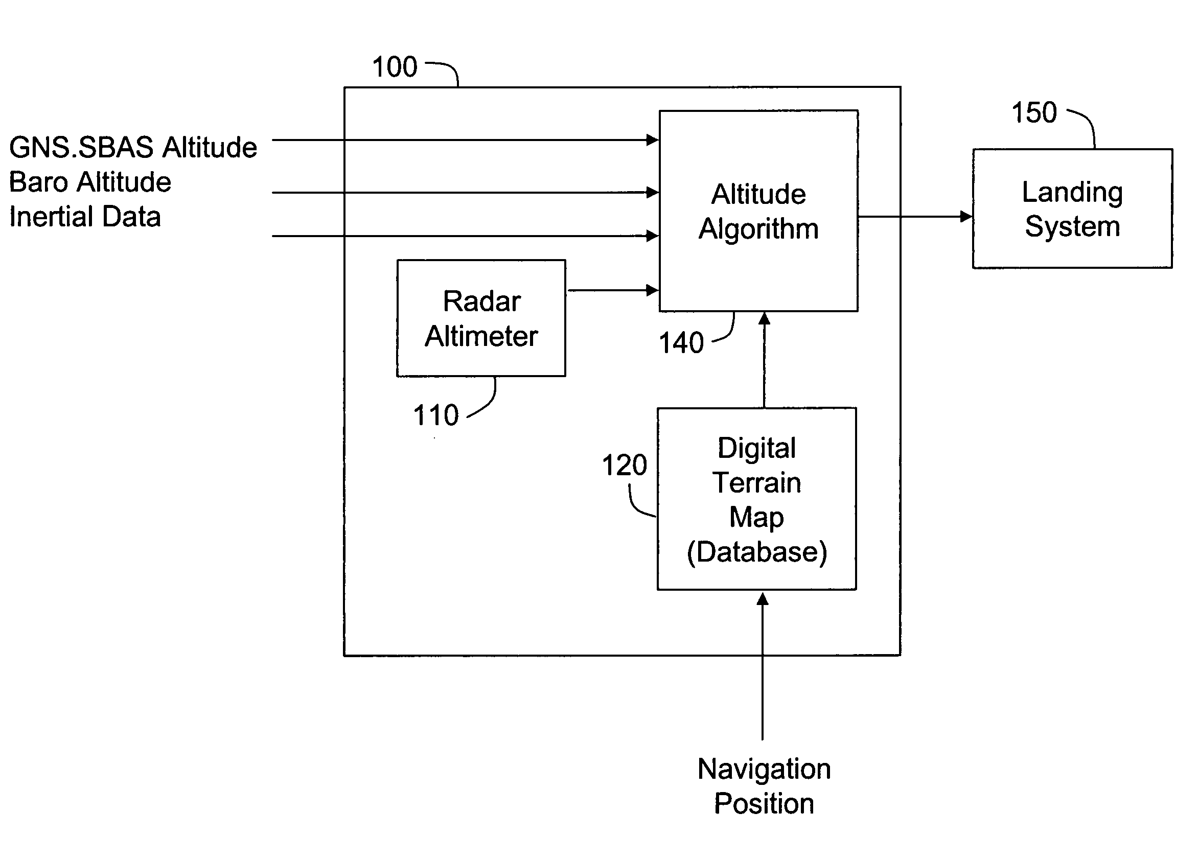
[0016]Aircraft landing systems that use altitudes derived from radar altimeters and terrain databases need to know with a high level of confidence whether or not derived altitude is accurate as the aircraft approaches the runway. This confidence level is sometimes referred to as integrity. For example, some aircraft landing systems may calculate a parameter called the vertical protection level (VPL) that indicates the maximum altitude measurement error to a 99.99999% confidence level. This high confidence level may require special procedures to certify that the digital terrain database is accurate in selected regions, for example, the region extending four miles beyond the end of a runway to a width of 0.5 mile on either side of the runway. As an alternative, only a small area in front of the runway may be certified, for example a 0.5 miles square area located three miles beyond the end of the runway, if that area is known to provide excellent accuracy for an altitude derived from r...


PUM


Abstract

An altitude measuring system is described that includes a radar altimeter configured to measure altitude and a digital terrain map database. The database includes data relating to terrain elevation and at least one data parameter relating to an accuracy of the terrain elevation data and the altitude measured by the radar altimeter. The system is configured to weigh an altitude derived from the terrain elevation data and the radar altimeter measurements according to the at least one data parameter.

Description

BACKGROUND OF THE INVENTION[0001]This invention relates generally to terrain height measurement, and more specifically, to methods and systems for measuring a terrain height which take into account seasonal and other variations in the terrain.[0002]Aircraft precision landing systems based on Global Navigation Systems (GNSs) such as the global positioning system (GPS) and Spaced Based Augmentation Systems (SBASs) such as the Wide Area Augmentation System (WAAS), which is a form of differential GPS, generally face a greater challenge for accuracy and integrity of vertical position (i.e., altitude above sea level) measurements than for horizontal position (i.e., latitude and longitude) measurements. As such, barometric altimeters and GNS / SBAS receivers are not sufficiently accurate for some precision landing operations.[0003]Landing systems have been proposed to improve altitude accuracy by augmenting GPS / WAAS systems with a radar altimeter that is combined with a digital terrain datab...

Claims


Application Information

Patent Timeline
Patent Type & Authority Patents(United States)
IPC IPC(8): G01S13/08G01S7/40G01S13/00G01S5/14G01S19/19
CPCG01C5/005G01S13/86G01S13/89G01S13/882G01S19/15G01S19/47
Inventor MANFRED, MARK T.CALL, CURTIS J.
Owner HONEYWELL INT INC
Why Eureka
Try Eureka