
Method and apparatus for increasing accuracy for locating cellular mobile station in urban area

a technology of urban area and cellular mobile station, applied in direction finders using radio waves, instruments, wireless commuication services, etc., to achieve the effect of increasing the accuracy of locating

Inactive Publication Date: 2006-12-19
HUAWEI TECH CO LTD
View PDF7 Cites 58 Cited by
  • Summary
  • Abstract
  • Description
  • Claims
  • Application Information

AI Technical Summary

Benefits of technology

[0011]In the above method for increasing the accuracy for locating a cellular mobile station in an urban area, the transmission of assistant pilot frequency and transmission of RTD measuring pilot frequency are both carried out in an independent transmission mode.

Problems solved by technology

However, because Non-Line-Of-Sight (NLOS) transmission paths exist ubiquitously in urban areas, there are severe NLOS errors in TDOA (time difference of arrival) measurement in urban areas, thus it is difficult to achieve the locating accuracy required by FCC in urban areas.
1) Intensive measurement is carried out in the urban area where NLOS exists to obtain a large quantity of empirical data about the distribution of channel multi-paths (amplitude measurement corresponds to the special case of mono-path). Then the position of the mobile station is corrected on the basis of the empirical data. Such an approach that improves the accuracy of locating a mobile station in urban areas through traversal measurement to obtain an empirical database requires vast workload. Moreover, once the urban area environment changes (e.g., when buildings are added or removed), the database will become invalid. To keep the database adapting to the changes of an urban area, usually a large quantity of measurement has to be performed.
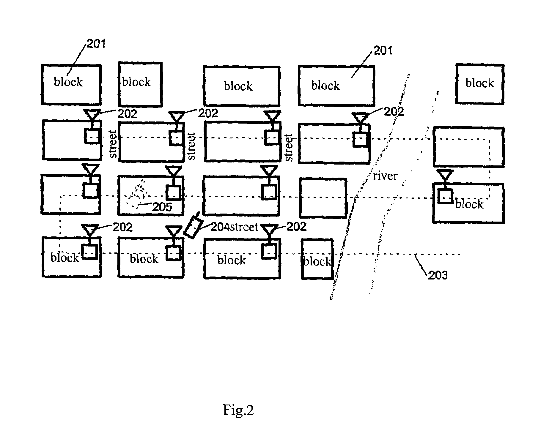
2) Several locating reference points (e.g., transponders) are added in the urban area where NLOS exists to correct NLOS error of a mobile station according to the signal characteristics of those reference points. In U.S. Pat. No. 5,926,133, a method for increasing the accuracy for locating a mobile station is disclosed, as shown in FIG. 2. The basic idea of this method is to place some transponders in the area of a specified block 201 as an assistant locating apparatus 202 to improve accuracy for locating a mobile station. The basic principle of improving locating accuracy with the assistant locating apparatus 202 (the transponders) is: the signals sent from the mobile station 204 and the signals transmitted from nearby transponders 202 are received at the base station through similar transmission paths. For each transponder, two locations are obtained: one is the location obtained through measuring (e.g., TDOA) the signals sent from the transponder and then through estimating of the location, and an NLOS error is included in the location; the other is the location measured accurately in advance. Through comparing the two locations, the NLOS error value may be obtained. An NLOS error vector may be created with NLOS errors of the transponders adjacent to the mobile station, and the NLOS error of the mobile station may be corrected on the basis of the NLOS error vector. Cable 203 is used to transfer data and provide power in order to enable the transponder to work. Position 205 of the mobile station is estimated by the assistant locating apparatus under the influence of NLOS. The working process of the method described in the patent is: (1) determining the approximate location of the mobile station 204; (2) starting ambient transponders to determine the approximate locations of those transponders with the signals transmitted by them; (3) constructing an NLOS error vector with the approximate locations of those transponders; (4) correcting the approximate location of the mobile station with the NLOS error vector to obtain the accurate location of the mobile station 204. The advantages of the method are that it doesn't need any assistance from the mobile station, and that the method is suitable for locating mobile stations with up links, and can adapt to the environmental variations of urban areas by adding transponders. However, to ensure the correction accuracy of the NLOS error, transponders have to be configured with enough accuracy, which may result in increased network construction costs. In addition, in 3G communication systems, the location of a mobile station has to be determined through measuring TDOA for down link in the IPDL mode. However, the method and apparatus described in U.S. Pat. No. 5,926,133 cannot be used in the IPDL mode in 3G communication systems.

Method used


Image

  • Method and apparatus for increasing accuracy for locating cellular mobile station in urban area
  • Method and apparatus for increasing accuracy for locating cellular mobile station in urban area
  • Method and apparatus for increasing accuracy for locating cellular mobile station in urban area

Examples


Embodiment Construction

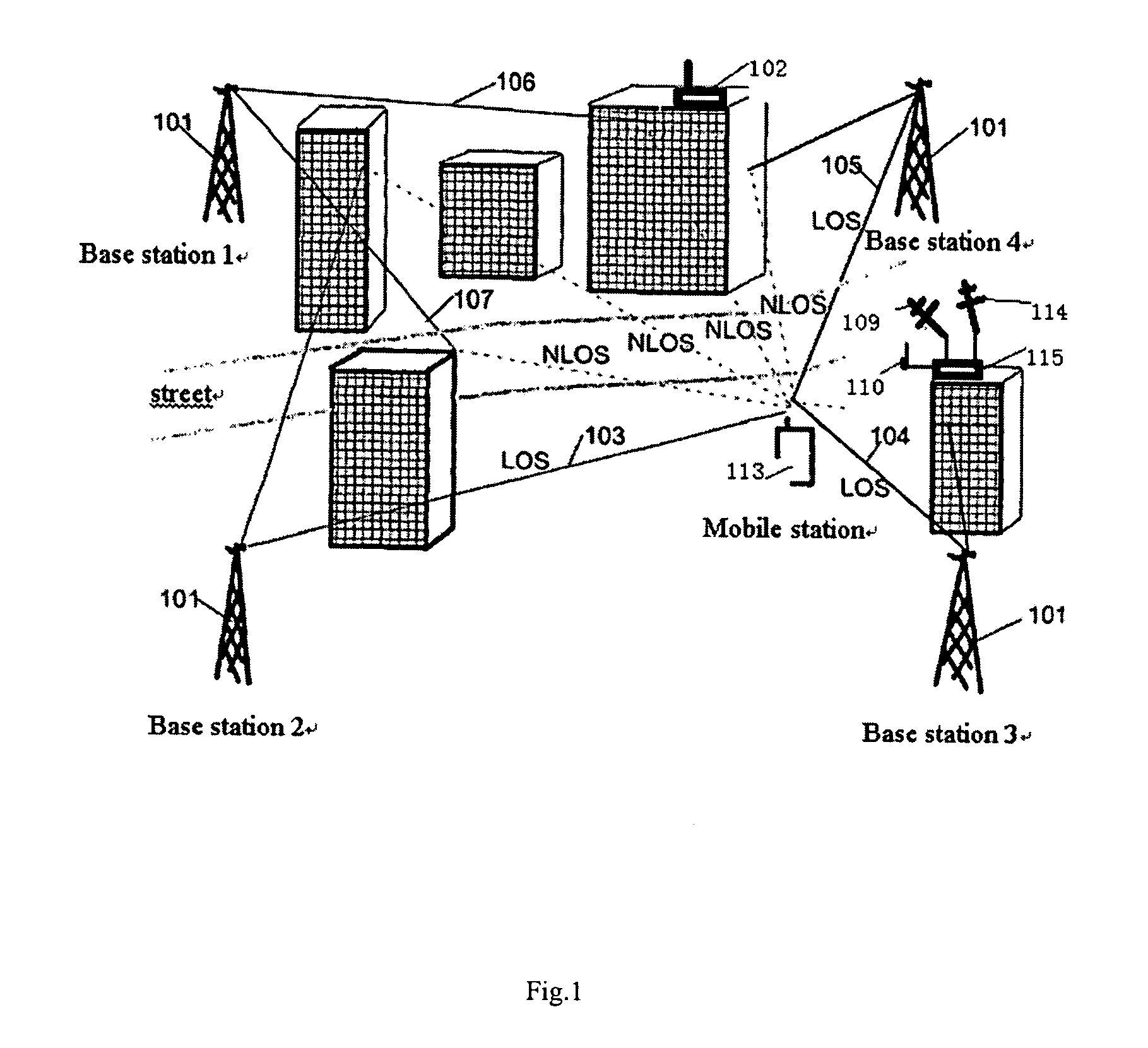
[0020]FIG. 1 shows the configuration relationship between the assistant locating apparatus for a mobile station and the cellular mobile communication system, wherein the assistant locating apparatus is used only when the locating error resulted from NLOS exceeds the specifications for a mobile station to be located. Several base station 101 and buildings are distributed around the mobile station 113. Due to the blockage of those buildings, signals from at least some of the base stations (e.g., base station 1 or 2) cannot be transmitted to the mobile station 113 directly. To increase LOS in the area where the mobile station 113 is located, an assistant locating apparatus is added in FIG. 1. The assistant locating apparatus in FIG. 1 comprises a RTD measuring antenna 109, an assistant locating pilot frequency transmitting antenna 110, an air interface antenna 114, a processor 115, and corresponding feed lines.

[0021]In FIG. 1, the RTD measuring antenna 109 faces the locating measuremen...


PUM


Abstract

The invention provides a method and apparatus for increasing the accuracy for locating a cellular mobile station in an urban area. The method is performed as follows: at first, if there is a request for location, the approximate position of a mobile station is determined by sector information, the time of arrival, and a time difference of arrival; then, the transmission of a locating pilot frequency for an adjacent assistant locating apparatus is initiated, and in the case of the transmission of the assistant locating pilot frequency, the time difference of arrival is measured once again; at the end of the measurement of the mobile station, the locating transmission of the assistant locating apparatus is closed; the assistant locating apparatus is requested to report the result of NLOS identification; with the measurement of the assistant locating pilot frequency by the mobile station and the result of NLOS identification, the position of the mobile station is estimated to acquire a more accurate position of the mobile station.

Description

[0001]This application is a continuation of international patent application no. PCT / CN01 / 01163, filed Jul. 9, 2001, designating the Unites States of America, the entire disclosure of which is incorporated herein by reference. Priority is claimed based on Chinese patent application no. 01105807.2, filed Mar. 30, 2001.FIELD OF THE INVENTION[0002]The present invention relates to a method and apparatus for increasing the accuracy for locating cellular mobile station in an urban area.BACKGROUND OF THE INVENTION[0003]Federal Communications Commission of USA (FCC) requires cellular mobile communication systems to be capable of locating mobile stations and explicitly specifies that in the case of assistant measurement of a mobile station, the probability of locating error being less than 50 meters be greater than 67% and the probability of locating error being less than 100 meters be greater than 95%. According to FCC regulations, dedicated technical specifications (25.305 and 25.395) are ...

Claims


Application Information

Patent Timeline
IPC IPC(8): H04Q7/20G01S5/10G01S5/02G01S5/12H04W64/00
CPCG01S5/02G01S5/0215G01S5/12H04W64/00G01S5/0218G01S5/011
Inventor DIAO, XINXILI, GANGDUAN, WEIMINGWU, JIANG
Owner HUAWEI TECH CO LTD
Learn More