System and method for enhanced situational awareness of terrain in a vertical situation display

a vertical situation and situational awareness technology, applied in the field of avionics systems, can solve the problems of limited physical space available to a vsd, difficulty for pilots to form a mental picture of the vertical situation at a glance, and conventional vsd systems may not take full advantage of the display space allocated to the vsd, so as to achieve efficient utilization of physical spa

Active Publication Date: 2007-04-24
HONEYWELL INT INC
View PDF21 Cites 36 Cited by
  • Summary
  • Abstract
  • Description
  • Claims
  • Application Information

AI Technical Summary

Benefits of technology

[0006]A VSD system according to the invention generates the VSD image such that the terrain under the flight plan, or under the current track of the aircraft, is displayed in a manner that efficiently utilizes the physical space allocated to the VSD. In the example embodiment, the vertical centering logic of the VSD system processes an input related to the current terrain altitude within the horizontal range of the VSD. The vertical centering of the VSD and / or the terrain displayed in the VSD is adjusted in response to the input such that the VSD vertical range is not “wasted” by displaying altitudes below the terrain elevation.

Problems solved by technology

The physical space available to a VSD is usually limited, and the limited space should be efficiently allocated to accommodate the VSD elements.
Conventional VSD systems may not take full advantage of the display space allocated to the VSD.
When terrain is not displayed, such as in FIG. 1, it may be difficult for the pilot to form a mental picture of the vertical situation at a glance.

Method used


Image

  • System and method for enhanced situational awareness of terrain in a vertical situation display
  • System and method for enhanced situational awareness of terrain in a vertical situation display
  • System and method for enhanced situational awareness of terrain in a vertical situation display

Examples


Embodiment Construction

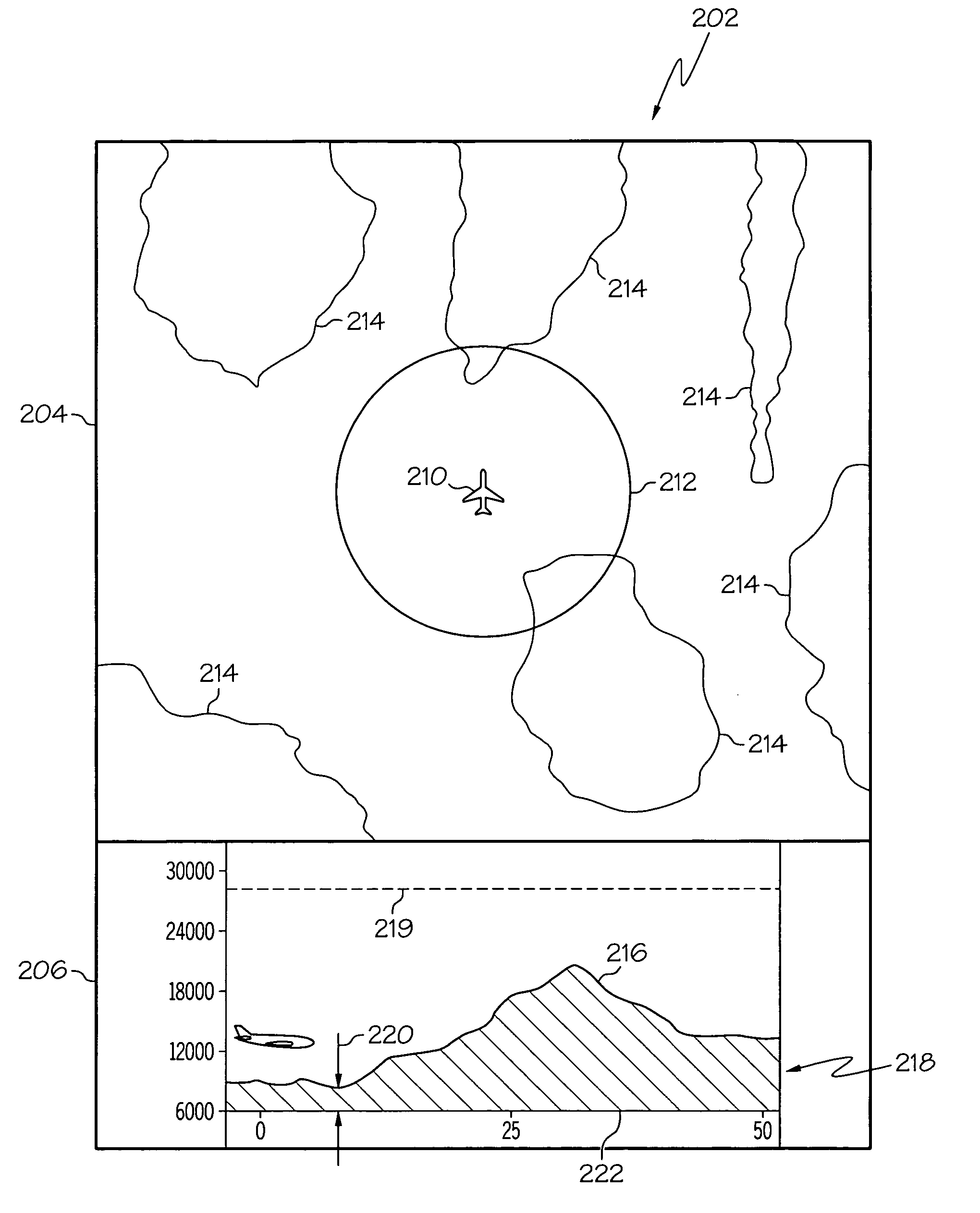
[0015]The following detailed description is merely exemplary in nature and is not intended to limit the invention or the application and uses of the invention. Furthermore, there is no intention to be bound by any expressed or implied theory presented in the preceding technical field, background, brief summary or the following detailed description.

[0016]The invention may be described herein in terms of functional and / or logical block components and various processing steps. It should be appreciated that such block components may be realized by any number of hardware, software, and / or firmware components configured to perform the specified functions. For example, an embodiment of the invention may employ various integrated circuit components, e.g., memory elements, digital signal processing elements, logic elements, look-up tables, or the like, which may carry out a variety of functions under the control of one or more microprocessors or other control devices. In addition, those skil...


PUM


Abstract

A vertical situation display (“VSD”) system according to the invention generates a terrain image that represents a profile view of terrain elevation relative to the position of an aircraft traveling above the terrain. The VSD system generates the VSD image such that the terrain image is biased toward the lower elevation region of the VSD screen, thus making efficient use of the available display area. The VSD image is also generated such that it is continuous across the lateral range of the VSD, thus ensuring that terrain is shown in the VSD at all practical times, depending upon the available range and any priority display rules.

Description

TECHNICAL FIELD[0001]The present invention relates generally to avionics systems such as flight display systems. More particularly, the present invention relates to a vertical situation display.BACKGROUND[0002]A vertical situation display (“VSD”) provides a two-dimensional representation of an aircraft, the aircraft flight plan, and terrain under the aircraft or projected aircraft track. The VSD is usually displayed in close proximity to a lateral map display, such that the vertical situation of the aircraft can be coordinated visually with the lateral situation of the aircraft. In a practical deployment, the VSD may be included in a primary flight display, a multifunction display, or other suitable display component on the aircraft. VSD systems are designed to prevent controlled flight into terrain (“CFIT”) by providing a display of the terrain relative to the present altitude of the aircraft. In this regard, a member of the aircraft flight crew can obtain information related to th...

Claims


Application Information

Patent Timeline
Patent Type & Authority Patents(United States)
IPC IPC(8): G01S13/94G01S13/95G01S13/935
CPCG01C5/00G01C23/00G08G5/0021G08G5/0086
Inventor GILLILAND, WILLIAM R.NICHOLS, TROY A.
Owner HONEYWELL INT INC
Why Eureka
Try Eureka