Supercharge Your Innovation With Domain-Expert AI Agents!

Spatial image information system and method for supporting efficient storage and retrieval of spatial images

a spatial image and information system technology, applied in the field of spatial image information system and method for efficient storage and retrieval of a chain of spatial images, can solve the problems of deteriorating performance, accumulating errors for a long period of voyage, and deteriorating performance, so as to improve the availability of the system, facilitate the retrieval of spatial images, and efficiently store different kinds of spatial image sequences

Active Publication Date: 2007-07-03
ELECTRONICS & TELECOMM RES INST
View PDF6 Cites 41 Cited by
  • Summary
  • Abstract
  • Description
  • Claims
  • Application Information

AI Technical Summary

Benefits of technology

[0010]It is an object of the present invention to provide to a spatial image information method and system capable of rapidly retrieving spatial images by efficiently storing different kinds of spatial image sequences in a database, and maintaining meta index information of the stored spatial images.
[0011]It is another object of the present invention to provide a spatial image information system which improves the availability of the system and enables easy implementation of applications by processing a retrieval query about spatial images according to a request from a client and having a real coordinate conversion function with respect to the spatial images.

Problems solved by technology

This INS is not affected by an external environment, and has the advantage in that it provides very accurate and sequential navigation data for a short period of voyage, while it has the disadvantage in that errors are accumulated for a long period of voyage.
This GPS has the advantage in that errors are not accumulated with the lapse of time and it is inexpensive, but has the disadvantage in that its performance deteriorates if at least four orbiting satellites are not secured.
However, the conventional spatial image information systems have the problems in that they use a method of simply storing related data in a file system in the unit of a file or a directory, or simply use only an interface of a database system as they cannot support an effective retrieving method for the spatial images even though they use the database, thereby deteriorating the their performance.

Method used


Image

  • Spatial image information system and method for supporting efficient storage and retrieval of spatial images
  • Spatial image information system and method for supporting efficient storage and retrieval of spatial images
  • Spatial image information system and method for supporting efficient storage and retrieval of spatial images

Examples


Embodiment Construction

[0024]A spatial image information method and system for efficient storage and retrieval of spatial images according to the preferred embodiment of the present invention will now be explained in detail with reference to the accompanying drawings.

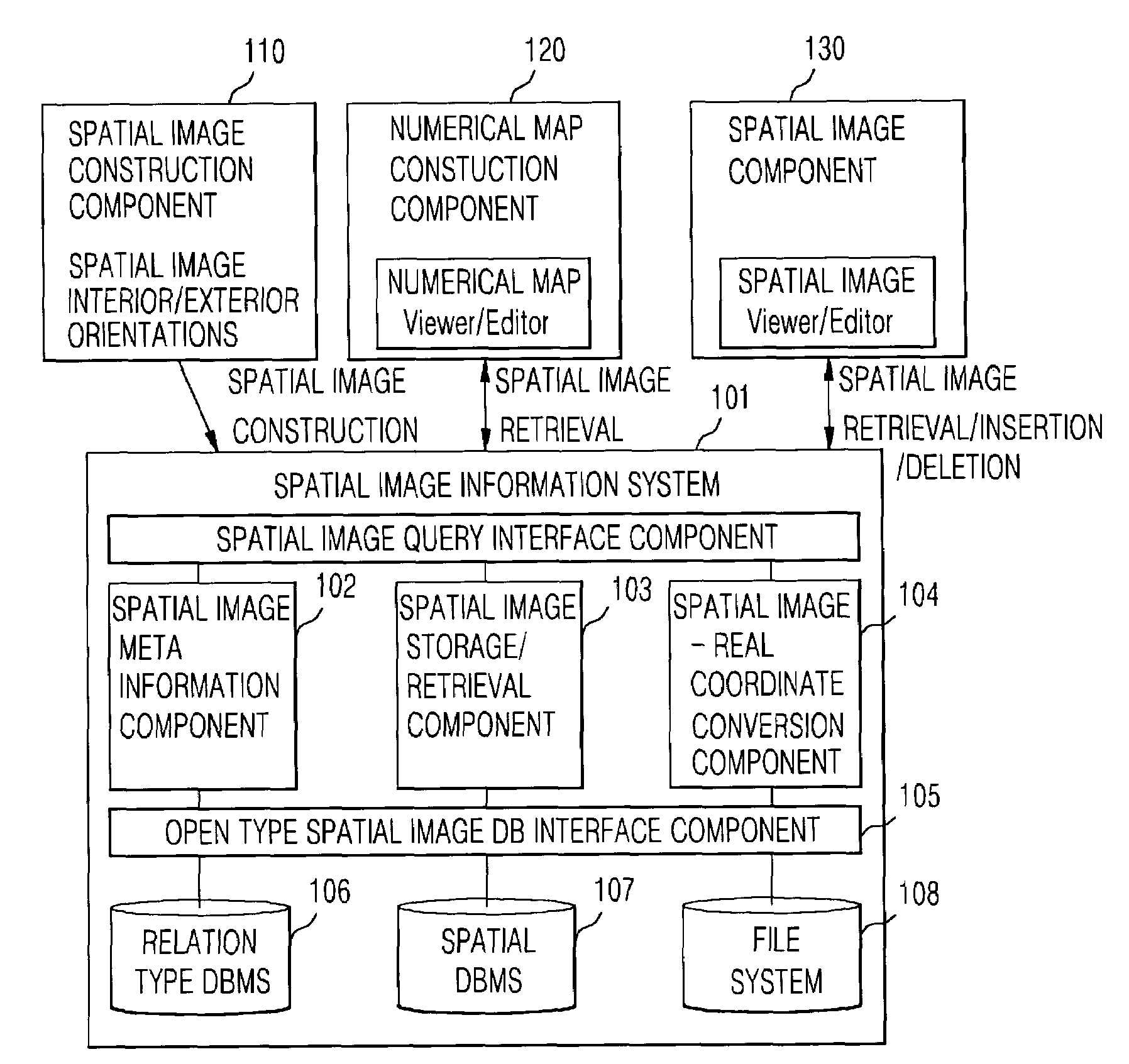
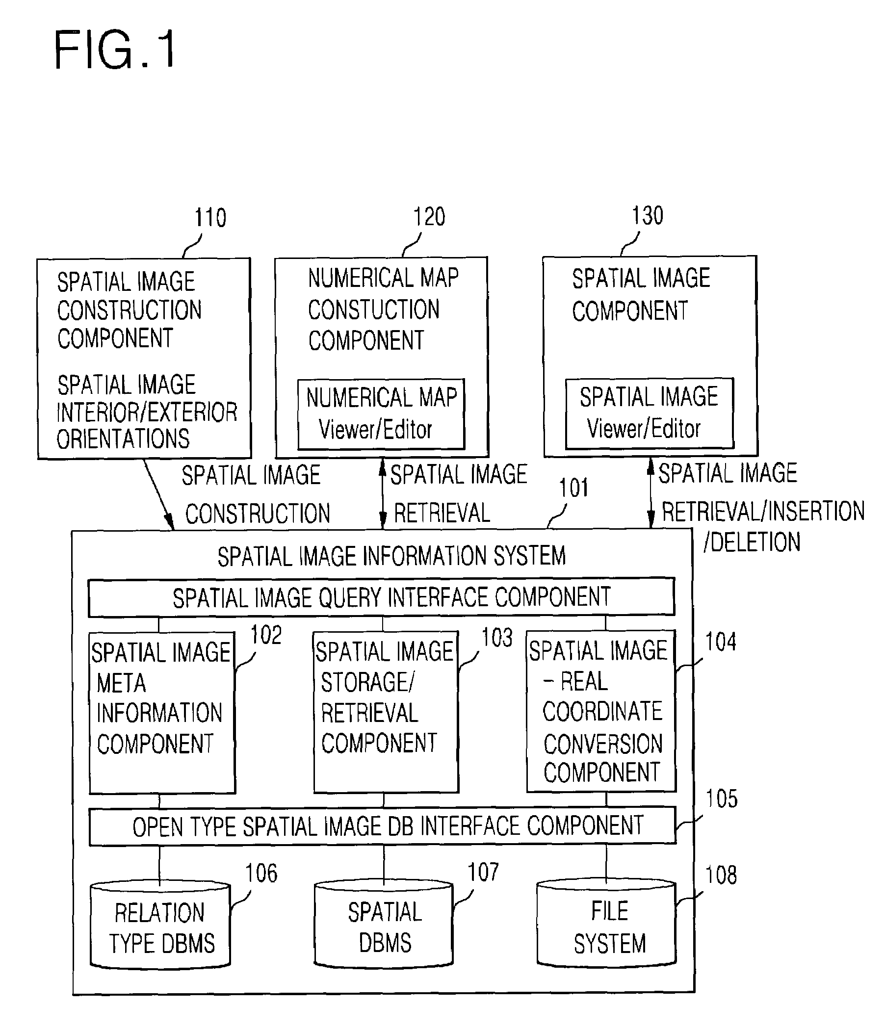
[0025]FIG. 1 is a block diagram illustrating the construction of a spatial image information system according to the present invention.

[0026]Referring to FIG. 1, the spatial image information system 100 according to the embodiment of the present invention includes a spatial image query interface component section 101 for performing an interface function with an external client, and processing a spatial image database (DB) construction query, spatial image retrieval / insertion / deletion queries, a spatial object information manipulation query in the spatial images, etc., a spatial image meta information component section 102 for managing schema and index information of spatial image sequences, a spatial image storage / retrieval component section ...


PUM


Abstract

Disclosed is a spatial image information method and system for rapid and efficient storage in a relation type database and retrieval and management of spatial images acquired by a combined system of a global positioning system (GPS), an inertial navigation system (INS), and an image acquisition device (i.e., CCD camera). The spatial image acquired by the GPS / INS / CCD camera combined system is combined with an exterior orientation composed of a camera position (x,y,z), accelerated velocity, slope and direction at the moment the image is acquired and an interior orientation acquired by a camera calibration, so that calculation of a specified spatial coordinate information becomes possible. The spatial image information system includes a section for efficiently storing a chain of still spatial image sequences acquired by the GPS / INS / CCD camera combined system, the exterior orientation, and the interior orientation in the relation type database, a section for storing spatial information recognized as the same object by a user as maintaining the relationship with the stored still spatial image sequences, a section for efficiently retrieving images that satisfy a certain spatial information operation from the still spatial image sequences, and an interface section for external systems.

Description

BACKGROUND OF THE INVENTION[0001]1. Field of the Invention[0002]The present invention relates to a method and system for efficient storage and retrieval of a chain of spatial images, and more particularly, to a spatial image information method and system capable of efficiently retrieving spatial images by storing in a database the spatial images acquired through an image acquisition device, in which a global positioning system (GPS) and an inertial navigation system (INS) are combined, along with an interior orientation and exterior orientation, and maintaining meta information and indexes of the stored spatial images.[0003]2. Background of the Related Art[0004]Recently, as diverse services using a geographic information system (GIS) have widely been highlighted, there is an increasing interest in a spatial image information system for more efficient storage and retrieval of acquired spatial images. In order to construct the geographic information system is used a navigation system ...

Claims


Application Information

Patent Timeline
IPC IPC(8): G06K9/54G06K9/32G06K9/60G06K9/00G03B19/00G06F17/30
CPCG01C11/025G06F17/30241G06F16/29
Inventor NAM, KWANG WOOLEE, JONG HUNYOO, JAE JUNJOO, IN HAKKIM, MIN SOO
Owner ELECTRONICS & TELECOMM RES INST
Features
  • R&D
  • Intellectual Property
  • Life Sciences
  • Materials
  • Tech Scout
  • Unparalleled Data Quality
  • Higher Quality Content
  • 60% Fewer Hallucinations
Learn More