Apparatus and method for producing video drive-by data corresponding to a geographic location

a technology of video drive-by and geographic location, which is applied in the field of system and method of generating image data of a geographic location, can solve the problem of not giving a user a sense of the neighborhood in which the property is located, and achieve the effect of reducing costs and gaining new efficiencies

Inactive Publication Date: 2008-06-17
VISUAL REAL ESTATE +2
View PDF2 Cites 75 Cited by
  • Summary
  • Abstract
  • Description
  • Claims
  • Application Information

AI Technical Summary

Benefits of technology

[0011]The above-above described system can further be provided with a plurality of processing means to add additional features or permit utilization of the system for specific applications. For example, processing means may be incorporated to provide a variety of geo-coded data layers in conjunction with the video drive-by data. Similarly, processing means can be provided for: creating geo-coded text, image and vector data which is superimposed onto the post processed video data that is transferred to the Internet; linking latitude and longitude data with video drive-by data; calculating a camera position of designated individual frames of video drive-by data using position data points captured before and after a designated frame position; for examining changes of relative position in the horizontal position of designated landmarks in a sequence of video image frames to create fixed landmark data points; examining images that match common image patterns to enable the creation of an accurate vector map of roads; providing OCR processing to generate a database of recognized text that is geo-coded with latitude and longitude coordinates based on camera orientation and relative position; and selecting video drive-by data or a given street address by calculating a centroid of a parcel and determining camera orientation and position to enable highly accurate delivery of video that is pointed toward the centroid of a parcel.
[0013]The present invention can be utilized in a variety of applications. For example, a system in accordance with the invention can offer invaluable assistance to local, county or state road and highway departments in planning new projects or tracking existing placements of signage, traffic signals, utility boxes, and other facilities and equipment locations. Administrators can preview and familiarize themselves with a targeted location in conjunction with assessing needs or assigning work details.
[0014]New layers of routing assistance can also be provided to emergency vehicle dispatching systems by including roadside views to allow rapid and accurate targeting of a destination. Tied in directly to county GIS mapping, the present invention can offer street level video into the neighborhood and directly to the street address, offering photographs of any property transmitted via wireless Internet to help the fire, police or rescue driver find his or her way.
[0015]With the capability to fully integrate, refine and unify existing county property records and GIS mapping resources, the system can enhance online presentations with parcel line enhanced ortho imagery, property images and now with video. Further, with the system, unification of property records and county mapping can evolve to tie in to one-click access to street level video segments allowing a user to virtually drive down any street, while highlighting any property and its surrounding neighborhood with parcel lines drawn on the photograph.
[0019]Similarly, property appraisers can gain new efficiencies at reduced costs by utilizing a video drive-by data archive of streaming street level video to select and capture freeze-frame video images of homes for sale needing an exterior photo. The system's unification of property data, MLS records, mapping with the video resources allows any property to be quickly selected, analyzed, and compared to equivalent property listings, generating reports with active links to both data and visuals that can be emailed at a moments notice.

Problems solved by technology

While such systems may also show views of a property from the street, they do not give a user a sense of the neighborhood in which the property is located.

Method used


Image

  • Apparatus and method for producing video drive-by data corresponding to a geographic location
  • Apparatus and method for producing video drive-by data corresponding to a geographic location
  • Apparatus and method for producing video drive-by data corresponding to a geographic location

Examples


Embodiment Construction

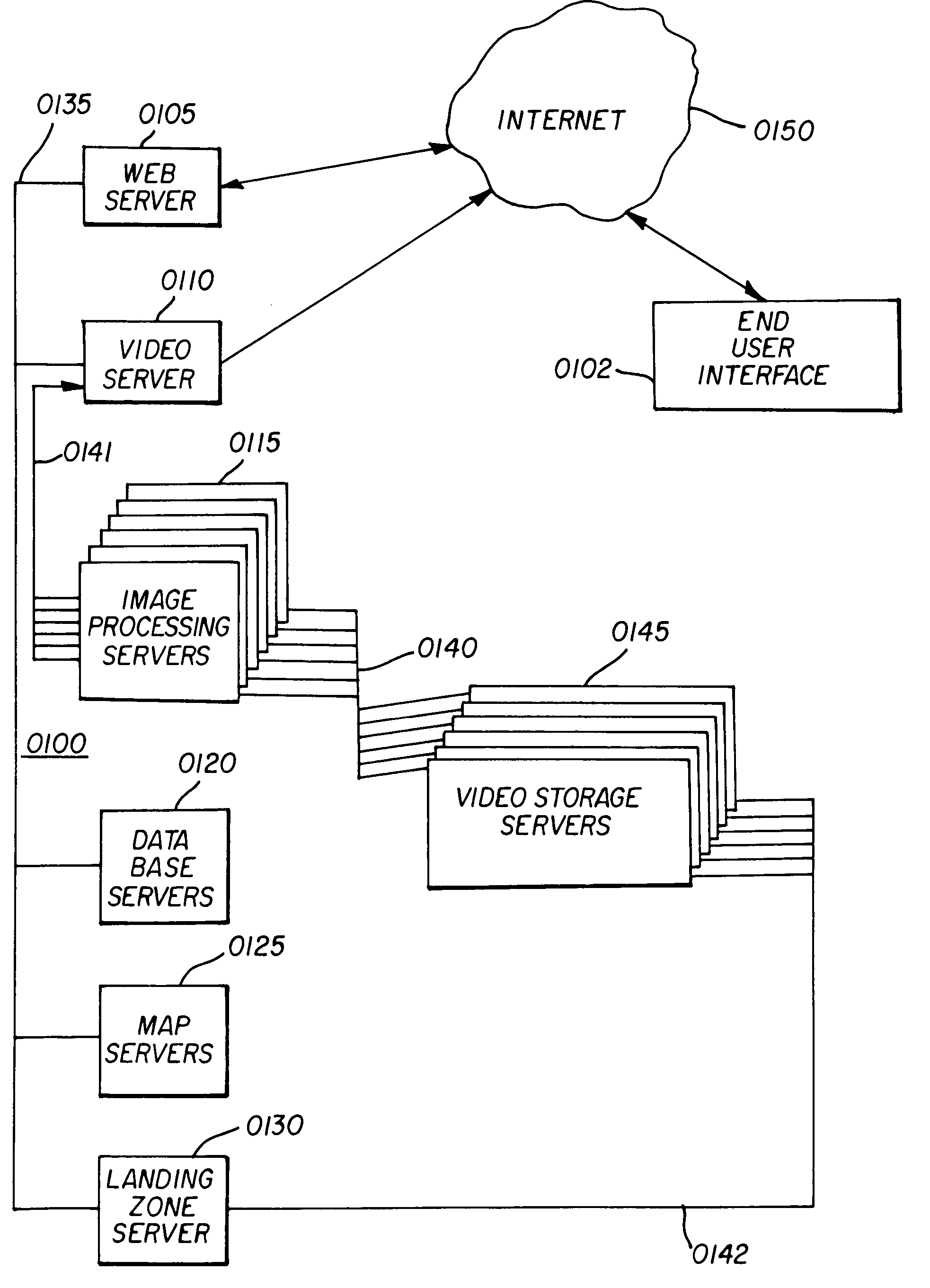
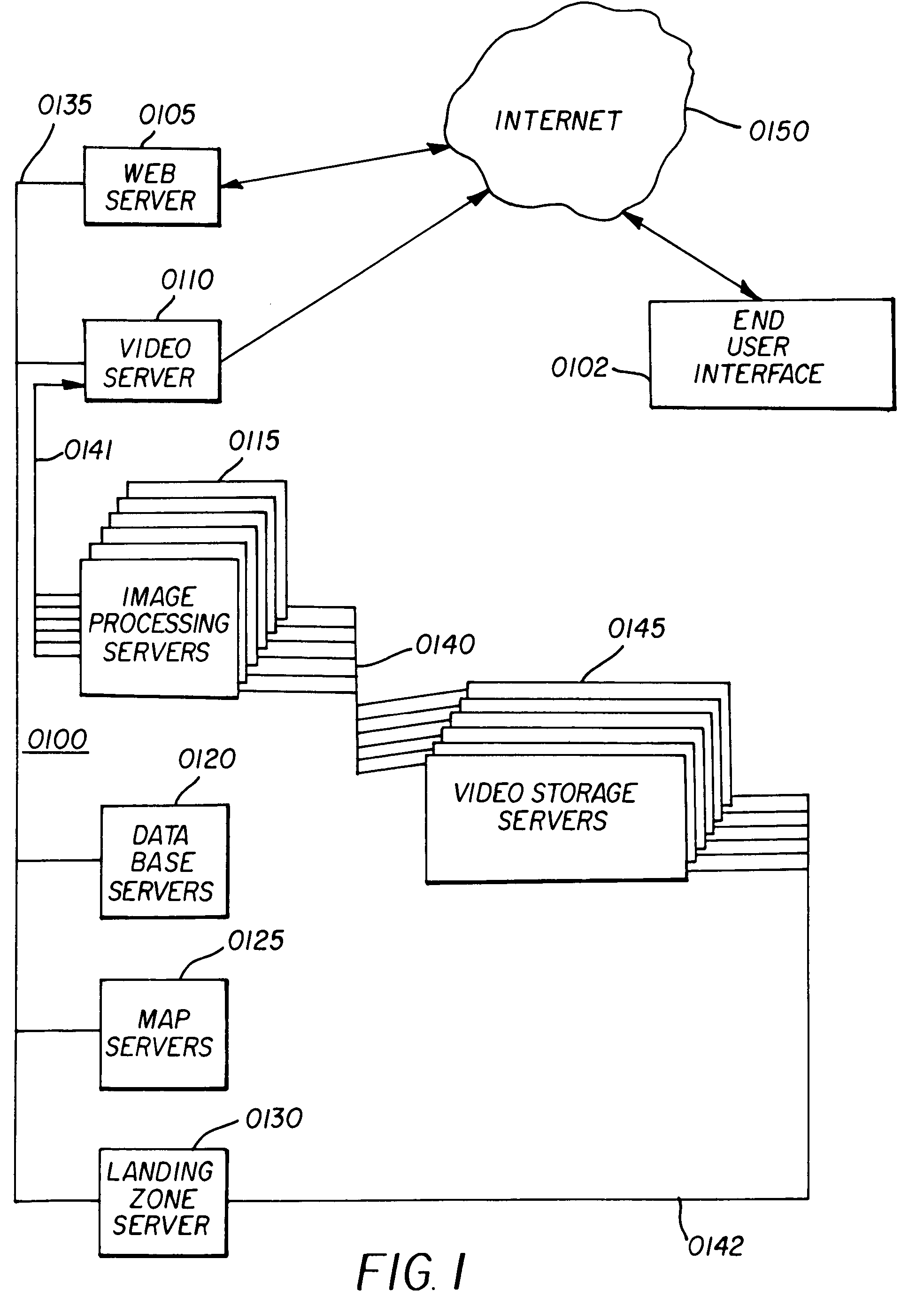
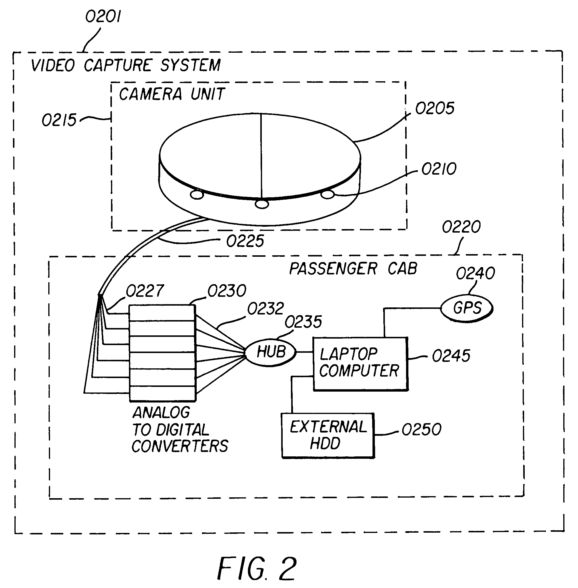
[0039]A Video & Data Server Farm 0100 in accordance with a preferred embodiment of the invention is illustrated in FIG. 1. The Video & Data Server Farm 0100 utilizes a set of servers to provide digital storage of video drive-by data, and processes the video drive-by data for deliver to an end user. The video drive-by data preferably includes video data and Global Positioning System (GPS) data or “geo position data” generated by a Video Capture System 0201 illustrated in FIG. 2. Specifically, video drive-by data is preferably stored on an external hard disk drive (HDD) 0250 of the Video Capture System 0201, and is then copied from the external HDD 0250 to a landing zone server 0130 of the Video & Data Server Farm 0100 for quality analysis and viewing via industry standard commercially available MPEG2 viewing software and file editors. The Video drive-by data, including the video data and GPS data, is transferred via a load network 0142 to be stored as video image files in video stora...


PUM


Abstract

A system and method of providing video drive-by data is provided to enable a street level view of a neighborhood surrounding a selected geographic location. The system includes a video and data server farm incorporation at least one video storage server that stores video image files containing video drive-by data that corresponds to a geographic location, a database server that processes a data query received from a user over the Internet that corresponds to a geographic location of interest, and an image processing server. In operation, the database server identifies video image files stored in the video storage server that correspond to the geographic location of interest contained in the data query, and transfers the video image files over a pre-processing network to the image processing server. The image processing server converts the video drive-by data to post processed video data corresponding to a desired image format, and transfers the post processed video data via post-processing network to the Internet response to the query.

Description

CROSS-REFERENCE TO RELATED APPLICATIONS[0001]This application claims priority from U.S. Provisional Patent Application Ser. No. 60 / 605,498 filed Aug. 31, 2004, the contents of which are hereby expressly incorporated herein by reference.BACKGROUND[0002]The present application relates in general to systems and methods of generating image data of a geographic location of interest. Specifically, the invention relates to an apparatus and method of generating video drive-by data corresponding to a selected geographic location. The video drive-by data provides a street level view of a neighborhood surrounding the selected geographic location, and can be further combined with other data sources in a variety of applications.[0003]Companies and individuals looking for real estate to rent, buy, insure or finance have historically had to physically travel to the property in order to visually verify the condition of the property. With the advent of the Internet, it has become possible for indivi...

Claims


Application Information

Patent Timeline
Patent Type & Authority Patents(United States)
IPC IPC(8): G01C21/00G01S19/48
CPCG06F17/30241G06F17/30817G06F17/3087G06F16/78G06F16/9537G06F16/29
Inventor MEADOW, WILLIAM D.GORDIE, JR., RANDALL A.
Owner VISUAL REAL ESTATE
Why Eureka
Try Eureka