
Method and Apparatus of Providing Street View Data of a Real Estate Property

a technology of street view and real estate, applied in the field of system and method of generating video driveby data, can solve the problems of not giving a user a sense of the neighborhood in which the property is located, limited in the scope of the subject matter that they can include, and difficult to locate and view a particular portion of interest of images captured as motion pictures, so as to enhance online presentations and achieve rapid and accurate targeting of destinations.

Inactive Publication Date: 2013-07-18
VISUAL REAL ESTATE
View PDF3 Cites 61 Cited by
  • Summary
  • Abstract
  • Description
  • Claims
  • Application Information

AI Technical Summary

Benefits of technology

Enables quick and accurate access to street-level video data of properties and neighborhoods, enhancing appraisal processes, reducing costs and time in loan commitments, and providing a unified platform for various applications including real estate, government, and emergency services.

Problems solved by technology

While such systems may also show views of a property from the street, they do not give a user a sense of the neighborhood in which the property is located.
Photographs can be useful because they are easily associated with a particular real estate parcel; however, they are limited in the scope of the subject matter that they can include.
Panoramas can increase the scope of the subject matter to a point, but are limited by a point of capture of the panoramic views.
However, it is sometimes difficult to locate and view a particular portion of interest of images captured as motion pictures.
In addition, correlation of particular portions of a motion picture with a particular real estate parcel can be difficult if the motion picture includes more than one real estate parcel.
For example, it is relatively difficult to locate and view a particular real estate parcel in the context of its neighborhood setting, or particular aspects of its setting.
Nor has there been a mechanism for accurately correlating ground level images with substantial portions of an aerial image in a consistent and orderly format that allows for the identification of a particular parcel of land and provide both aerial and ground level views of the parcel, as well as a surrounding area of the parcel.
Substantial portions of ground level images have not been correlated with aerial images or with geopolitical indicators, in part, because there has not been any image vehicle capable to providing a format of high quality and accurate representations of street level images capable of being matched to macro level image data.

Method used


Image

  • Method and Apparatus of Providing Street View Data of a Real Estate Property
  • Method and Apparatus of Providing Street View Data of a Real Estate Property
  • Method and Apparatus of Providing Street View Data of a Real Estate Property

Examples


Embodiment Construction

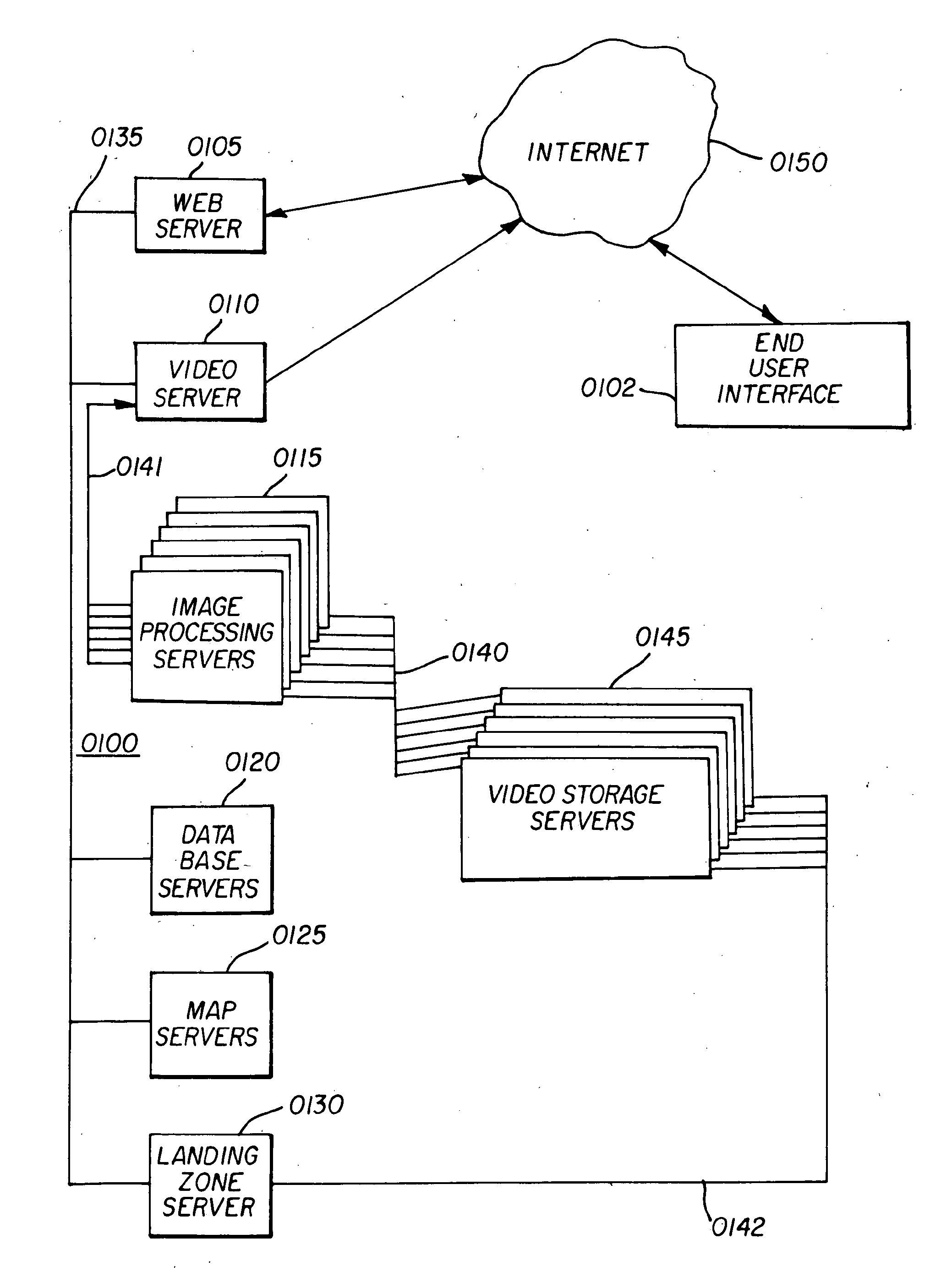
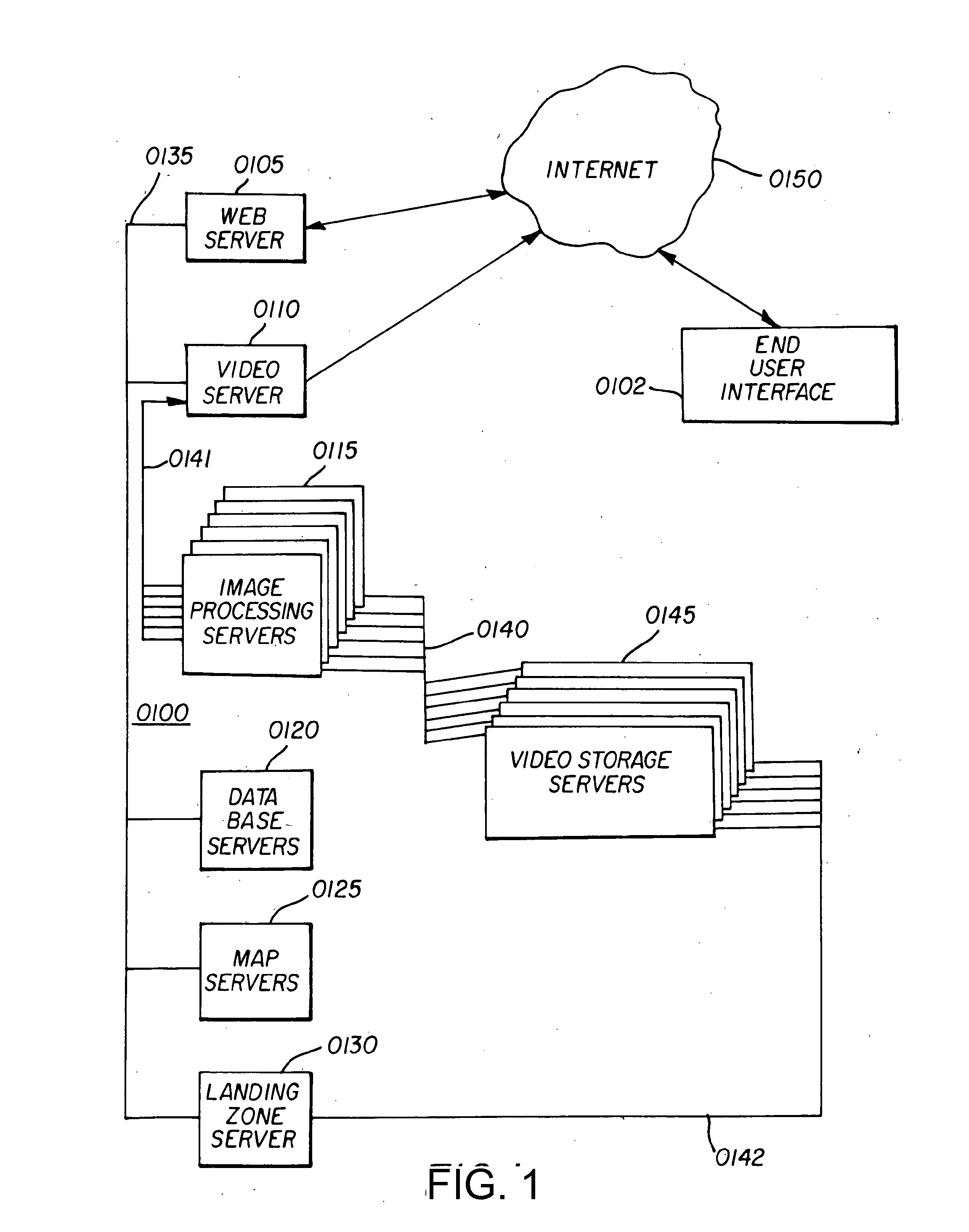
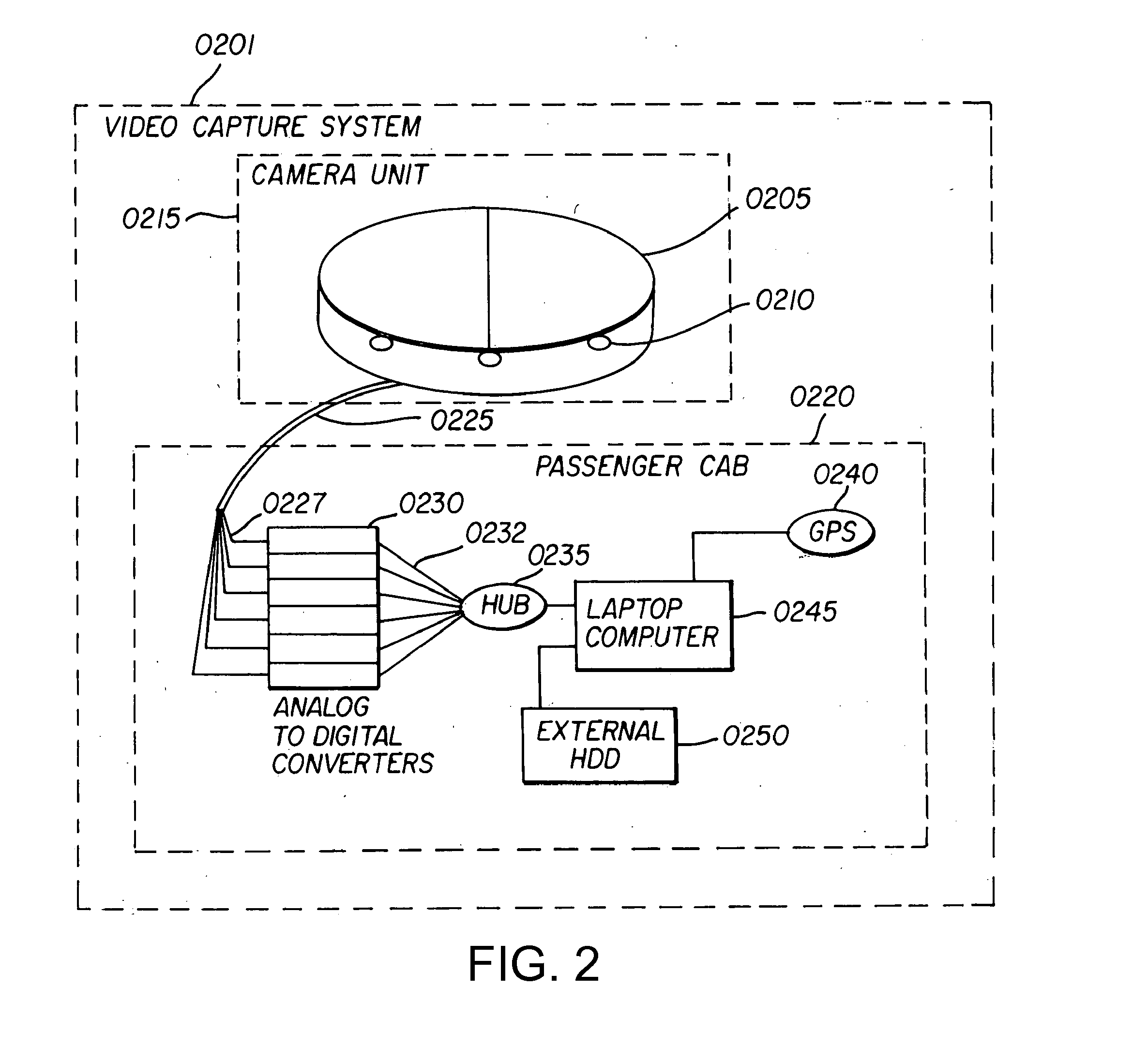
[0066]A Video & Data Server Farm 0100 in accordance with a preferred embodiment of the invention is illustrated in FIG. 1. The Video & Data Server Farm 0100 utilizes a set of servers to provide digital storage of video drive-by data, and processes the video drive-by data for delivery to an end user. The video drive-by data preferably includes video data and Global Positioning System (GPS) data or “geo position data” generated by a Video Capture System 0201 illustrated in FIG. 2. Specifically, video drive-by data is preferably stored on an external hard disk drive (HDD) 0250 of the Video Capture System 0201, and is then copied from the external HDD 0250 to a landing zone server 0130 of the Video & Data Server Farm 0100 for quality analysis and viewing via industry standard commercially available MPEG2 viewing software and file editors. The Video drive-by data, including the video data and GPS data, is transferred via a load network 0142 to be stored as video image files in video stor...


PUM


Abstract

Video drive-by data provides a street level view of a neighborhood surrounding a selected geographic location. A video and data server farm incorporates a video storage server that stores video image files containing video drive-by data corresponding to a geographic location, a database server that processes a data query received from a user over the Internet corresponding to a geographic location of interest, and an image processing server. In operation, the database server identifies video image files stored in the video storage server that correspond to the geographic location of interest contained in the data query and transfers the video image files over a pre-processing network to the image processing server. The image processing server converts the video drive-by data to post-processed video data corresponding to a desired image format and transfers the post-processed video data via a post-processing network to the Internet in response to the query.

Description

CROSS REFERENCE TO RELATED APPLICATION[0001]This application is a continuation of, and claims priority under 35 U.S.C. §120 from, nonprovisional U.S. patent application Ser. No. 13 / 481,912 entitled “Three Dimensional Image Data Models,” filed on May 28, 2012. Application Ser. No. 13 / 481,912, in turn, is a continuation of, and claims priority under 35 U.S.C. §120 from, nonprovisional U.S. patent application Ser. No. 12 / 036,197 entitled “Methods and Apparatus for Generating Three-Dimensional Image Data Models,” filed on Feb. 22, 2008, now U.S. Pat. No. 8,207,964. Application Ser. No. 12 / 036,197, in turn, is a continuation-in-part of, and claims priority under 35 U.S.C. §120 from, nonprovisional U.S. patent application Ser. No. 11 / 216,465 entitled “Apparatus and Method for Producing Video Drive-By Data Corresponding to a Geographic Location,” filed on Aug. 31, 2005, now U.S. Pat. No. 7,389,181. Application Ser. No. 11 / 216,465, in turn, claims priority under 35 U.S.C. §120 from provisio...

Claims


Application Information

Patent Timeline
Patent Type & Authority Applications(United States)
IPC IPC(8): H04N7/18
CPCG06T17/05G06F3/0484H04N5/23238G06T3/4038H04N7/18G06F17/30244G06T19/006G06F17/30265H04N7/181G06Q30/0629G06Q50/16G06Q30/0278G06T11/60G06Q10/10G06F17/21G06Q30/0623G06F17/3082H04N5/28G06T17/20G06F16/7867G06F16/29G06F16/78G06F16/9537H04N23/698G06F16/50G06F16/58G06F40/10G06F16/787G06F16/587
Inventor MEADOW, WILLIAM D.GORDIE, JR., RANDALL A.
Owner VISUAL REAL ESTATE
Learn More