Method and apparatus for determining smoothed code coordinates of a mobile rover

a mobile rover and code coordinate technology, applied in the field of coordinate determination using satellite signals, can solve the problems of ambiguity resolution, the difference in the phase delay of a carrier signal received by the base and rover receiver may substantially exceed one cycle, and it is not possible to measure the integer number of cycles from the incoming satellite signal

Active Publication Date: 2008-10-21
TOPCON GPS
View PDF3 Cites 23 Cited by
  • Summary
  • Abstract
  • Description
  • Claims
  • Application Information

AI Technical Summary

Problems solved by technology

The practical implementation of these advantages, which might otherwise be guaranteed by the measurement of the carrier phases, runs into the problem of ambiguity resolution for phase measurements.
Therefore, the difference in the phase delays of a carrier signal received by the Base and Rover receivers may substantially exceed one cycle.
Second, it is not possible to measure the integer number of cycles from the incoming satellite signals; one can only measure the fractional part.
One specific type of abnormal error is a phase lock loop (PLL) cycle slip.
When the duration is long enough, tracking is lost.
When considering the use of the above technologies, there is a trade-off between accuracy and cost.
Thus, while providing accurate positioning results, this mode of operation is also the most expensive, in terms of equipment costs, processing power, and complexity.
Alternatively, the least accurate technique is the stand alone system described above, which provides only meter-level accuracy.
While less accu

Method used


Image

  • Method and apparatus for determining smoothed code coordinates of a mobile rover
  • Method and apparatus for determining smoothed code coordinates of a mobile rover
  • Method and apparatus for determining smoothed code coordinates of a mobile rover

Examples


Embodiment Construction

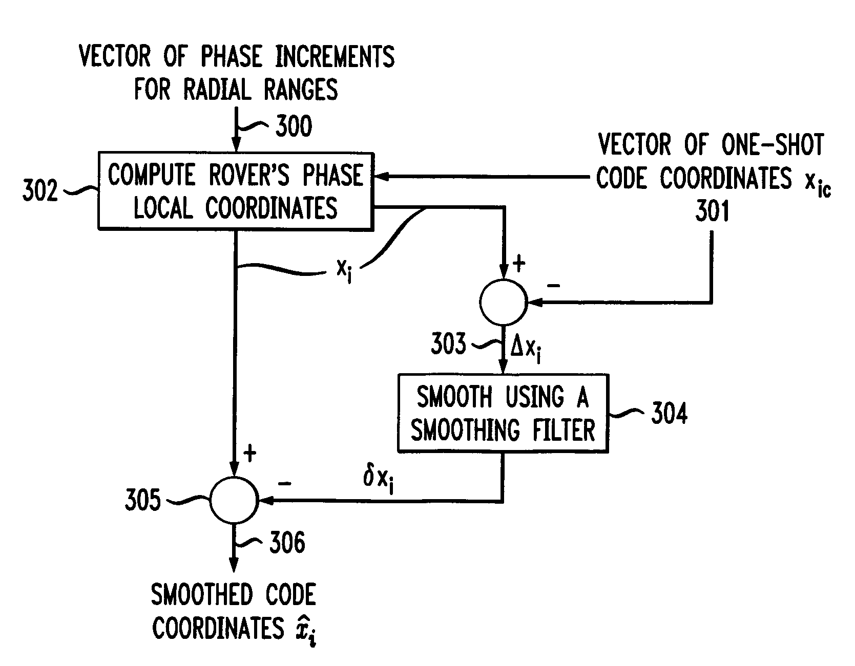
1. General Principle of Smoothing Code Coordinates

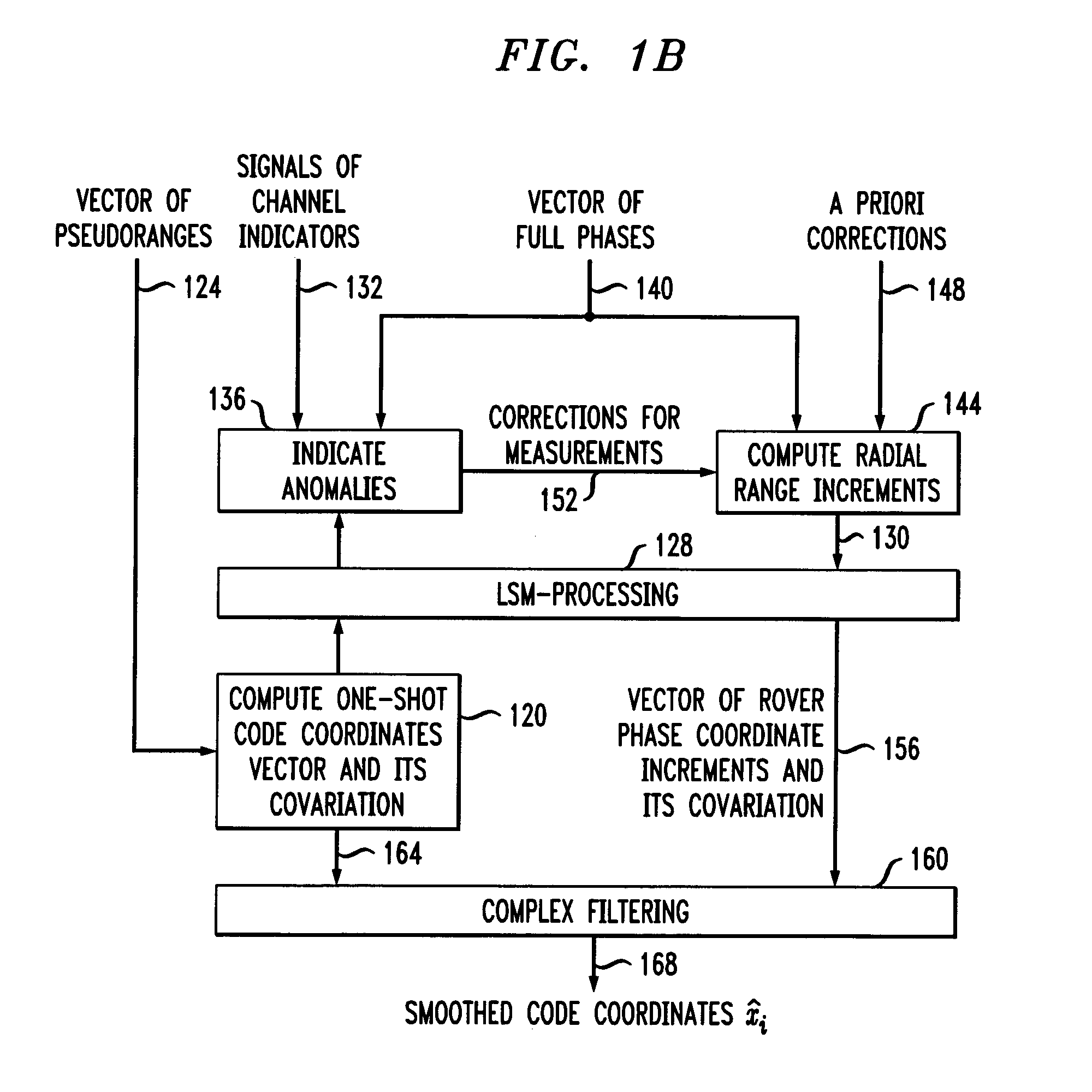
[0031]The present invention provides a method and apparatus of processing navigational measurements to measure coordinates of a mobile rover in a adverse environment. Receiver operation is assumed to be in an adverse environment (and / or with no corrections from the base station) when RTK is not used. Under such conditions, only code coordinates may be determined, and fast fluctuations are smoothed to improve accuracy. The present invention can also improve DGPS accuracy or enable the determining of RTK fixed solutions more quickly when more sophisticated equipment is used.

[0032]A standalone single-frequency receiver measures pseudo-ranges to the satellites in view (with the help of delay lock loop (DLL) tracking systems) and full carrier phases (with PLL circuits). The known method of smoothing code pseudo-ranges with carrier phase measurements in each satellite channel separately is often inefficient in an environment with heavy int...


PUM


Abstract

Disclosed is a method for determining coordinates of a mobile rover. The method includes determining a vector of one-shot code coordinates of the mobile rover. The method also includes determining a vector of phase increments by determining full phase differences for each navigation satellite in a plurality of navigation satellites in view at a discrete time interval (called a time epoch) and at a previous time epoch in a plurality of time epochs. A vector of radial range increments is determined from the full phase differences. A vector of rover phase coordinate increments is also determined using the vector of radial range increments. The vector of one-shot code coordinates and the vector of rover phase coordinate increments are then filtered to determine, at each time epoch, smoothed code coordinates of the mobile rover. Measured phase increments are cleared up from abnormal measurements.

Description

BACKGROUND OF THE INVENTION[0001]The present invention relates generally to coordinate determination using satellite signals, and more particularly to coordinate determination using one-shot code coordinates and increments of carrier phase coordinates of satellite signals.[0002]Satellite positioning systems, such as GPS (USA) and GLONASS (Russia), are well known in the art and are intended for highly accurate self-positioning of users possessing special navigation receivers. A navigation receiver receives and processes radio signals transmitted by satellites located within line-of-sight distance of the receivers. The satellite signals comprise carrier signals that are modulated by pseudo-random binary codes. The receiver measures the time delay of the received signal relative to a local reference clock or oscillator. These measurements enable the receiver to determine the so-called pseudo-ranges between the receiver and the satellites. The pseudo-ranges are different from the ranges...

Claims


Application Information

Patent Timeline
IPC IPC(8): H04B7/185G01S19/07G01S19/05G01S19/20G01S19/41
CPCG01S19/43
Inventor ZHODZISHSKY, MARK I.VEITSEL, VICTOR A.ZINOVIEV, ALEXEY
Owner TOPCON GPS
Why Eureka
Try Eureka