System and method for precision geolocation utilizing multiple sensing modalities

a technology of multiple sensing modes and geolocation algorithms, applied in the field of radio frequency signal emitter geolocation systems, can solve the problems of not being able to adequately handle the problem, not being able to determine the geolocation of moving signal emitters by using currently known tdoa/fdoa techniques alone, and being very sensitive to signal emitter velocity induced errors. to achieve the effect of improving the accuracy of tdoa/fdoa techniques

Active Publication Date: 2012-03-13
RAYTHEON CO
View PDF23 Cites 103 Cited by
  • Summary
  • Abstract
  • Description
  • Claims
  • Application Information

AI Technical Summary

Benefits of technology

[0005]Embodiments of the present invention provide a system and method for determining the geolocation of a signal emitter moving at an unknown velocity by detecting at least one tentative velocity and at least one tentative location of the signal emitter to unbias the TDOA / FDOA solutions to improve the accuracy of the TDOA / FDOA techniques. The tentative velocity and location of the signal emitter may be detected by various methods such as radar, sonar, visible light or infrared / hyper spectral images (such as television, or FLIR) and laser / LADAR.
[0006]Embodiments of the present invention combine multiple sensor modalities to improve TDOA / FDOA accuracy for locating the geolocation of a non-stationary signal emitter. Also, embodiments of the present invention use the tentative velocity and location of the signal emitter as hypotheses to remove target velocity biases from TDOA / FDOA geolocation solutions of the moving signal emitter.
[0012]In an aspect of the embodiment, the processor may be configured to utilize the tentative velocity of the signal emitter to reduce a bias in the solutions of the geolocation of the signal emitter.

Problems solved by technology

However, when the signal emitter is not stationary, currently known TDOA / FDOA location algorithms or techniques are very sensitive to signal emitter velocity induced errors.
Therefore, determining the geolocation of a moving signal emitter by using currently known TDOA / FDOA techniques alone is less than satisfactory.
However, there appear to be no currently known TDOA / FDOA techniques that can adequately handle the problem caused by a non-stationary signal emitter.

Method used


Image

  • System and method for precision geolocation utilizing multiple sensing modalities
  • System and method for precision geolocation utilizing multiple sensing modalities
  • System and method for precision geolocation utilizing multiple sensing modalities

Examples


application example 1

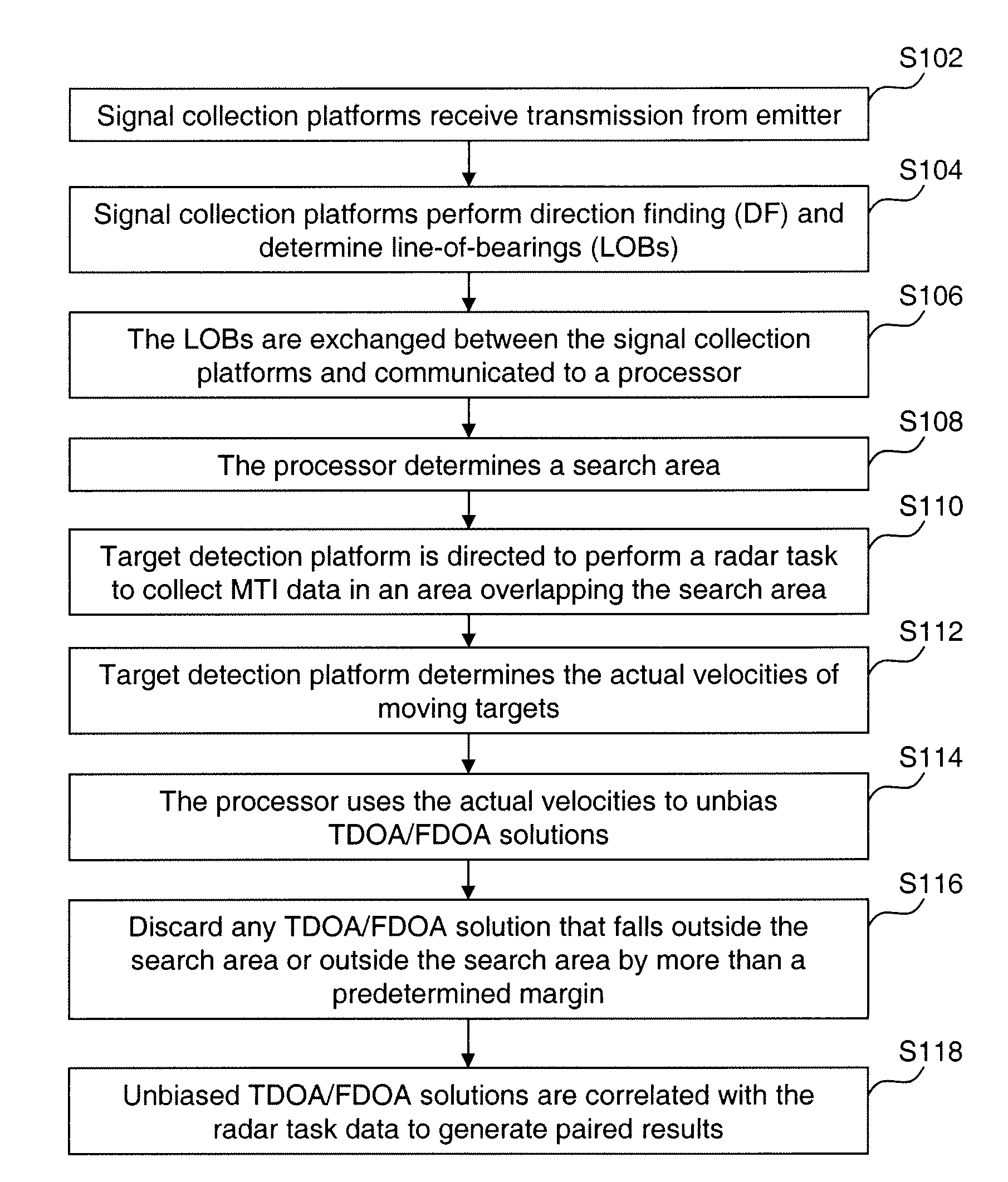
[0043]The following example illustrates an application of the embodiments of the present invention.

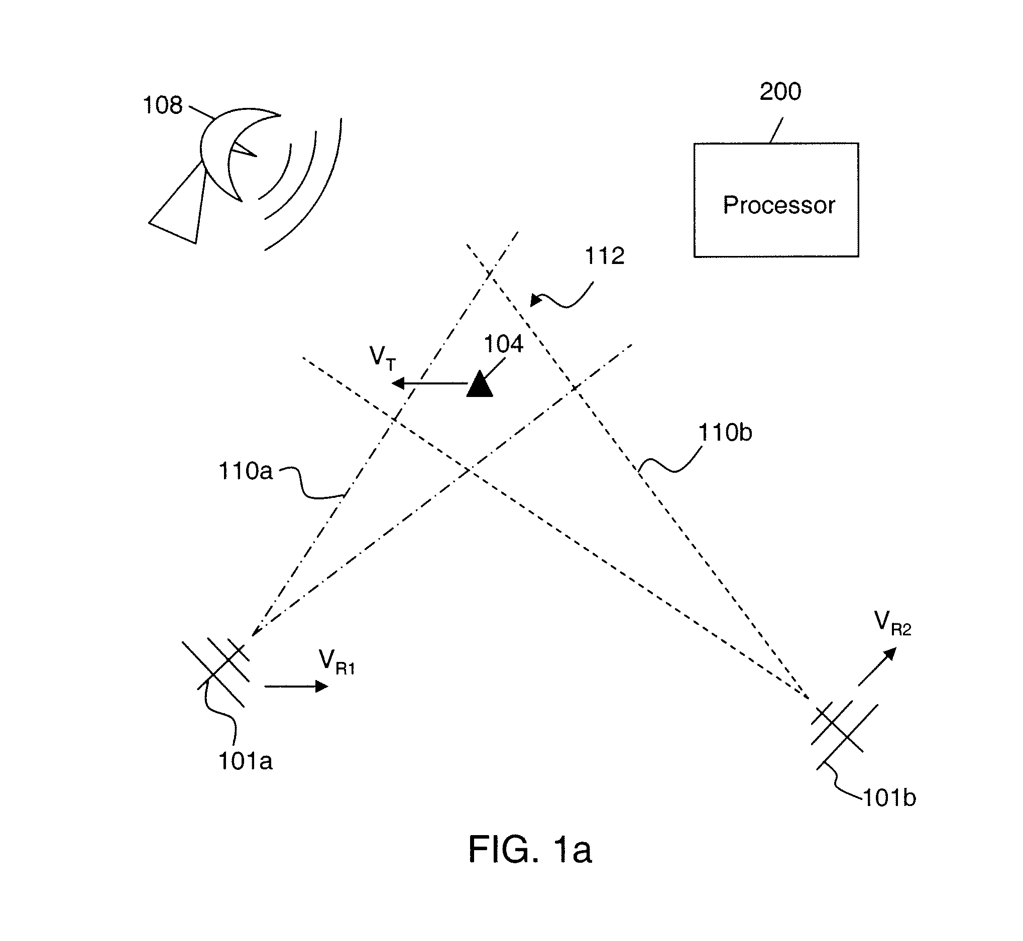
[0044]Referring to FIG. 3, two aircraft 302 and 304 each have signals intelligence (SIGINT) sensors capable of measuring time of arrival. At an initial time “0,” the target 306, which has a velocity of 15 km / hr at a 30 degree angle, is at a range of R1 and R2 from aircraft 302 and 304, respectively. At this time, each aircraft 302 and 304 has a speed of 900 km / hr. One of the aircraft, for example, aircraft 304, is equipped with a GMTI radar, and makes a single measurement of the target 306 with a range accuracy of 20 m, a cross-range accuracy of 100 m, and a range rate accuracy of 0.5 m / s. Further, the aircraft 302 and 304 utilize their SIGINT sensors to measure the TDOA with an accuracy of 10 ns, and a revisit time of 5 s. Observable data from two aircraft are combined in accordance an exemplary embodiment of the invention. That is, the GMTI measurement from aircraft 304 is combined w...

application example 2

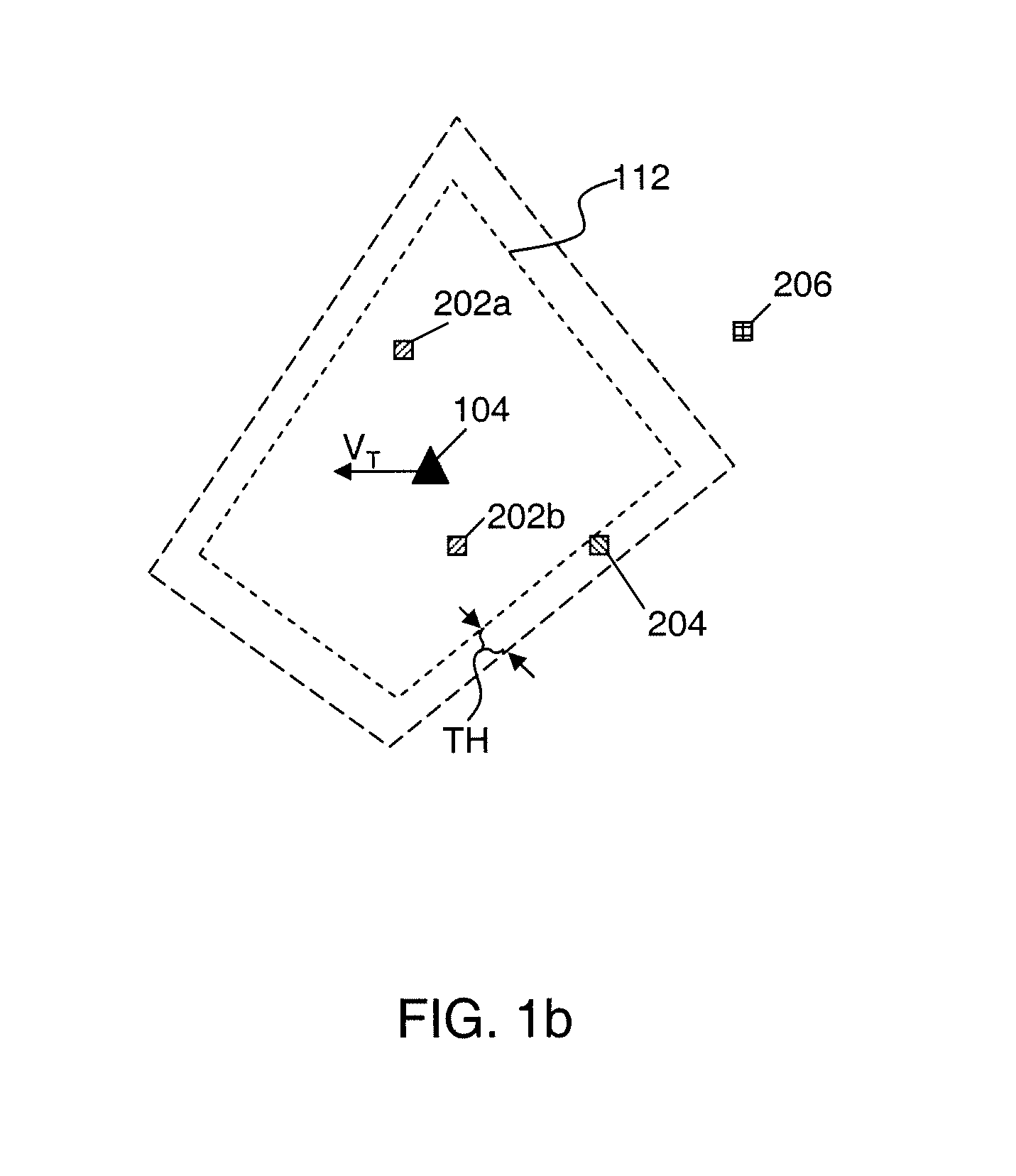
[0047]Assuming a scenario where it is desired to rapidly determine the location of a mobile terminal (e.g. a mobile phone) of interest. When the mobile terminal is operating, multiple airborne signal collection platforms (hereinafter “platforms”) receive an RF transmission emitted from the mobile terminal. Then each of the signal collection platforms performs DF LOB which is exchanged between the platforms via air-to-air links. The intersection of the DF LOBs forms a polygon in which the mobile terminal lies. Subsequent DF LOBs may be processed the same way forming a sequence of polygons. The outline of the polygons and signal information of the RF transmission are displayed to the operator of the system through a suitable display. Further, the system automatically looks for any existing track within the polygons. For the convenience of description, the following description assumes only one polygon and no track being detected.

[0048]Each platform that has visibility to the polygon c...


PUM


Abstract

A system and method for determining the geolocation of a signal emitter moving at an unknown velocity by combining signal data of a target detection platform (e.g., a radar system) and signal data collected by two or more moving signal collection platforms (e.g., RF signal receivers). In one embodiment, the target detection platform determines tentative location and velocity of the signal emitter, and the signal collection platforms are configured to perform TDOA and / or FDOA analysis of the collected signal data corresponding to a signal of the signal emitter. In one embodiment, solutions provided from the TDOA and / or FDOA analysis are unbiased by using the tentative velocity of the signal emitter, and the geolocation of the signal emitter is determined by matching the TDOA / FDOA solutions and the detected tentative location.

Description

BACKGROUND OR THE INVENTION[0001]The present invention generally relates to radio frequency signal emitter geolocation systems and, more particularly, to a system combining multiple sensor modalities to improve the accuracy of using time difference of arrival (TDOA) and / or frequency difference of arrival (FDOA) techniques to determine the geolocation of a signal emitter.[0002]The ability to determine the geolocation of a signal emitter (e.g., a mobile phone, a walkie-talkie, etc.) has many applications such as search / rescue operations, police / border protection, maritime patrol / rescue and military actions. TDOA and FDOA are known methods for using radio frequency (RF) signals measured at two or more separated receivers to determine the geolocation of a radio frequency signal emitter (hereinafter “signal emitter”). TDOA locates the signal emitter by exploiting the difference in the path length or range difference between the signal emitter and each of the receivers and the correspondi...

Claims


Application Information

Patent Timeline
Patent Type & Authority Patents(United States)
IPC IPC(8): G01S13/42
CPCG01S5/04G01S13/524G01S13/86
Inventor NOBLE, WILLIAM B.CRAWFORD, DUNCAN L.GUILD, JEFFREY M.
Owner RAYTHEON CO
Why Eureka
Try Eureka