System and method for roll angle indication and measurement in flying objects

a technology of flying objects and roll angles, applied in the field of flying object roll angle indication and measurement systems, can solve the problems of limited angular orientation measurement range, low accuracy of curve fitting, and low power requirement for operation, so as to reduce noise and measurement errors, the effect of more accurate curve fitting and more accurate curve fitting

Active Publication Date: 2012-09-04
OMNITEK PARTNERS LLC
View PDF14 Cites 19 Cited by
  • Summary
  • Abstract
  • Description
  • Claims
  • Application Information

AI Technical Summary

Benefits of technology

[0025]The method generating step can comprise using the output of the pair of polarized RF sensor cavities and the third RF sensor cavity to make the curve fitting more accurate and reduce the effects of noise and measurement error.
[0026]The method can further comprise: receiving the signal at one or more additional polarized RF sensor cavities positioned at different roll angle locations on the projectile; analyzing an output of the additional polarized RF sensor cavities resulting from the received signal; and the generating step can include generating the curve based on the output of the additional polarized RF sensor cavities to make the curve more accurate and reduce the effect of noise and measurement errors.

Problems solved by technology

However, optical based angular position sensory systems suffer from several disadvantages, including operation only in the line of sight between the two objects; accurate measurement of relative angular orientation only if the objects are relatively close to each other; limited range of angular orientation measurement; relatively high power requirement for operation; requirement of relatively clean environment to operate; and in military applications the possibility of exposing the site to enemy and jamming.
Optical gyros do not have most of the above shortcomings but are relatively large, require a considerable amount of power, and are difficult to harden for high G firing accelerations.
Optical methods such as tracking of projectiles with surface mounted reflectors and the like have also been developed, which are extremely cumbersome to use even during verification testing, suffer from all the aforementioned shortcomings, and are impractical for fielded munitions.
As a result, optical angular position sensors are generally not suitable for munitions and other similar applications.
The main problem with magnetometers is that they cannot measure orientation of the object about the magnetic field of the earth.
Other important issues are low sensitivity; requirement of an accurate map of the magnetic field in the area of operation; and sensitivity to the presence of vehicles and the like in the area, the configuration of which usually varies in time, particularly in an active war theatre.
With such systems, measurement of full spatial orientation of an object (relative to the fixed radar or a second object) is very difficult.
It is also very difficult and costly to develop systems that could track multiple projectiles.
The GPS, however, does not provide altitude and angular orientation information.
These include the fact that GPS signals may not be available along the full path of the flight, and the measurements cannot be made updated fast enough to make them suitable for guidance and control purposes.
As a result, such sensors are inherently shock, vibration and high G acceleration hardened.
Inertial based angular orientation sensors, however, generally suffer from drift and noise error accumulation problems.
In such sensors, the drift and the measurement errors are accumulated over time since the acceleration has to be integrated to determine the angular position.
As a result, the error in the angular position measurement increases over time.
As a result, errors in both measurements are included in the relative angular orientation measurement, thereby increasing the error even further.
The firing acceleration, however, would saturate the inertial devices and require relatively long periods of time to settle.
The disclosed sensors cannot however be used to measure roll angle positioning of the object or similarly bring the object to an arbitrary roll angle positioning without similarly rotating the plane of polarization of the reference source.

Method used


Image

  • System and method for roll angle indication and measurement in flying objects
  • System and method for roll angle indication and measurement in flying objects
  • System and method for roll angle indication and measurement in flying objects

Examples


Embodiment Construction

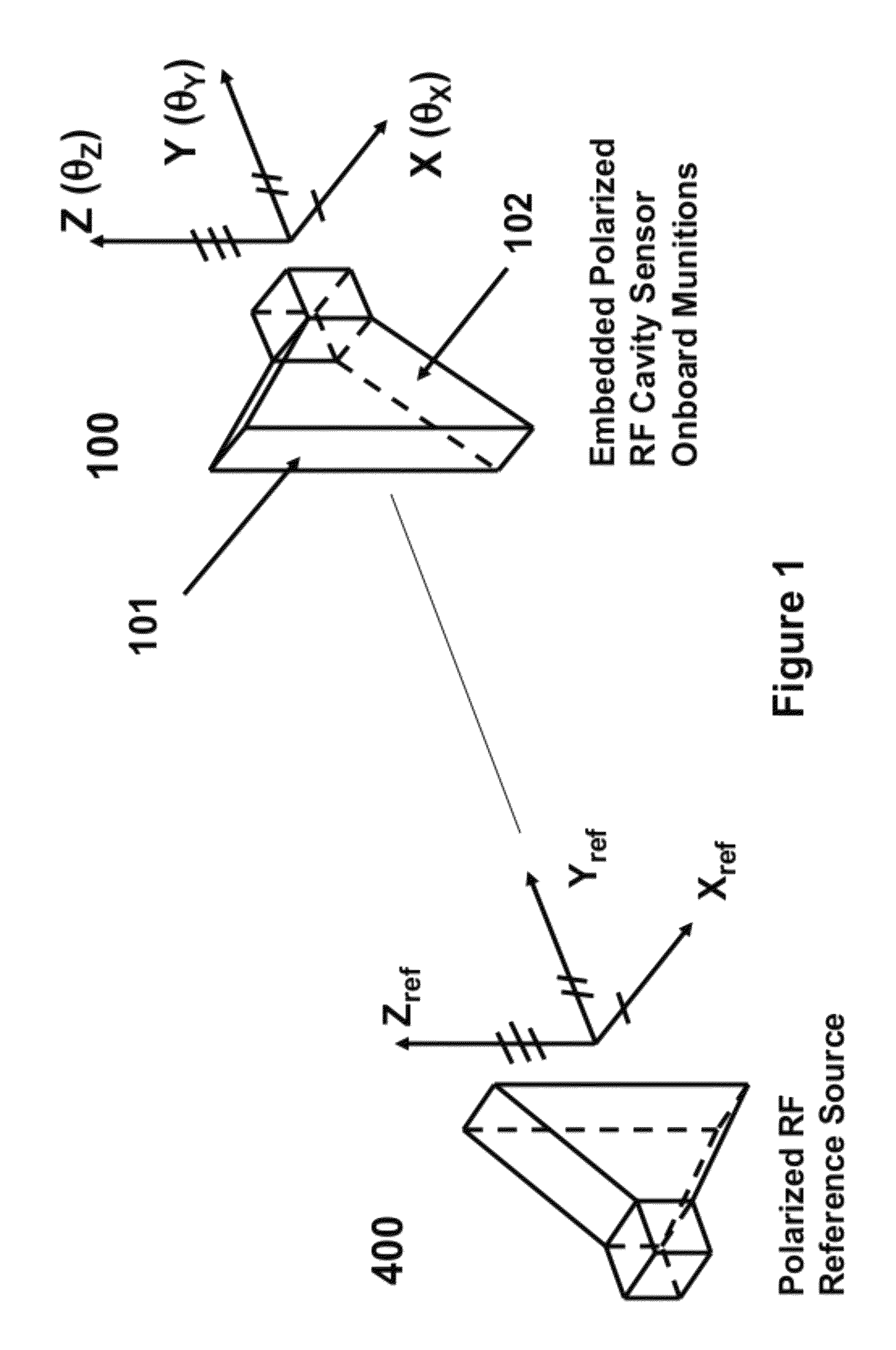
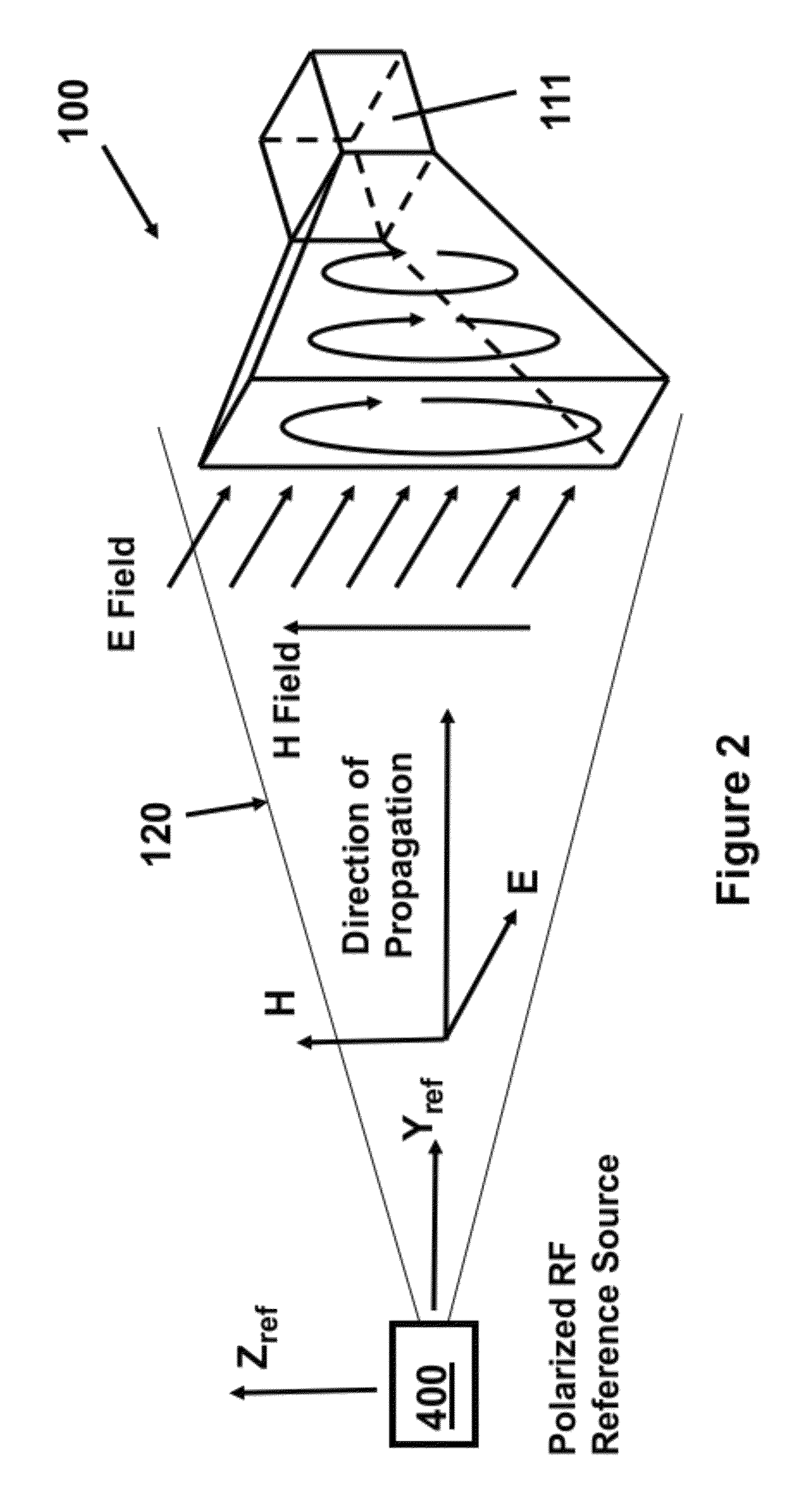
[0045]Referring now to FIGS. 1 and 2 there is shown a representation of the polarized radio frequency (RF) cavity sensor 100 and its operation with respect to a polarized RF reference (illumination) source (illuminator) 400 affixed to a ground control station or to a (ground or airborne or space) mobile platform.

[0046]An electromagnetic wave 120 consists of orthogonal electric (E) and magnetic (H) fields. The electric field E and the magnetic field H of the illumination beam of the illuminating source 400 are mutually orthogonal to the direction of propagation of the illumination beam. In the case of the polarized RF reference (illumination) source 400, the planes of E and H fields are fixed and stay unchanged in the direction of propagation. Thus, the polarized RF reference source 400 establishes a coordinate reference system with known and fixed orientation and a polarization with a known plane of reference. The polarized RF cavity sensor 100 reacts in a predictable manner to a po...


PUM


Abstract

A method for onboard determination of a roll angle of a projectile. The method including: transmitting a polarized RF signal from a reference source, with a predetermined polarization plane; receiving the signal at a pair of polarized RF sensor cavities positioned symmetrical on the projectile with respect to the predetermined polarization plane; receiving the signal at a third polarized RF sensor cavity positioned such that it receives a maximum signal at zero roll angle positioning; differentiating between up or down positioning of the desired roll angle position based on an output from a fourth sensor on the projectile; analyzing an output of the pair of polarized RF sensor cavities and the third RF sensor cavity resulting from the received signal and an output of the fourth sensor; generating a curve based on the output of the pair of polarized RF sensor cavities and the third RF sensor cavity indicating a relationship between roll angle and the third sensor output; and determining a roll angle positioning of the projectile based on the curve.

Description

CROSS-REFERENCE TO RELATED APPLICATIONS[0001]This application is a continuation-in-part of U.S. application Ser. No. 12 / 395,758 filed on Mar. 2, 2009 now U.S. Pat. No. 7,977,613, the entire contents of which is incorporated herein by reference.FIELD OF THE INVENTION[0002]The present invention relates to sensors and systems designed to indicate if an object is directed up or down relative to the vertical direction on earth (i.e., in the direction of gravity) and its deviation from the vertical direction for guidance and control purposes, in particular to sensors that a flying object can use to roll to a desired roll angle relative to the vertical plane.BACKGROUND OF THE INVENTION[0003]For guidance and / or steering purposes, all manned and unmanned mobile platforms, such as land vehicles, powered airborne platforms such as aircrafts and rockets, and non-powered airborne platforms such as gun-fired munitions and mortars, require onboard information as to their absolute position and orie...

Claims


Application Information

Patent Timeline
Patent Type & Authority Patents(United States)
IPC IPC(8): G01S13/66G01C1/00G01S13/00F42B30/00
CPCF41G7/305F42B15/01G01B21/22
Inventor RASTEGAR, JAHANGIR S.PEREIRA, CARLOS M.
Owner OMNITEK PARTNERS LLC
Why Eureka
Try Eureka