GNSS integrated multi-sensor control system and method

a multi-sensor control system and integrated technology, applied in the direction of distance measurement, steering initiation, instruments, etc., can solve the problems of ionosphere-induced propagation delay errors, gps satellite clock reference errors, and process of position determination subject to a number, so as to facilitate a number of precise steering tasks, accurate and precise vehicle positioning guidance and control

Active Publication Date: 2014-02-11
AGJUNCTION
View PDF409 Cites 100 Cited by
  • Summary
  • Abstract
  • Description
  • Claims
  • Application Information

AI Technical Summary

Benefits of technology

[0016]Disclosed herein is a method for providing accurate and precise vehicle positioning guidance and control with automatic steering capabilities. The present invention utilizes a series of separate sensors which may serve as temporary reliable guidance devices when GNSS signals are weak, and are recalibrated when GNSS signals are strong. This reliable positioning information gathering allows multiple vehicles to operate in cooperation with each other using autonomous task delegation and control. A versatile system is described that facilitates a number of precise steering tasks for a variety of functions using proportional hydraulic control and state-of-the-art GNSS positional systems.

Problems solved by technology

In standalone GPS systems that determine a receiver's antenna position coordinates without reference to a nearby reference receiver, the process of position determination is subject to errors from a number of sources.
These include errors in the GPS satellite's clock reference, the location of the orbiting satellite, ionosphere induced propagation delay errors, and troposphere refraction errors.
These targets may be lost due to obstructions such as trees, hills, or merely because the satellite has orbited out of view.
Depending on the separation distance between the two GPS receivers, many of the errors mentioned above will affect the satellite signals equally for the two receivers.
Such additional sensors are, however, prone to lose calibration and then need to be corrected.
Automatic steering systems using GNSS data tend to lose accuracy.
If the system calibration is off the steering controller may tend to over-correct, resulting in erratic turns.
Additionally, loss of the GNSS signal could affect the automatic steering function.

Method used


Image

  • GNSS integrated multi-sensor control system and method
  • GNSS integrated multi-sensor control system and method
  • GNSS integrated multi-sensor control system and method

Examples


Embodiment Construction

I. Introduction, Environment, and Preferred Embodiment

[0030]Generally, a preferred embodiment of the present invention consists of components which allow a farming vehicle, with or without an attached farming implement, to automatically guide itself around a field and perform a plurality of functions, leading to precision farming. Said vehicle may be in constant communication with other vehicles similarly equipped for the same or different tasks. The vehicles within such a network are capable of making decisions amongst themselves about where to go and what to do to best perform assigned tasks based on the global position of each vehicle relative to each other and the location of said tasks.

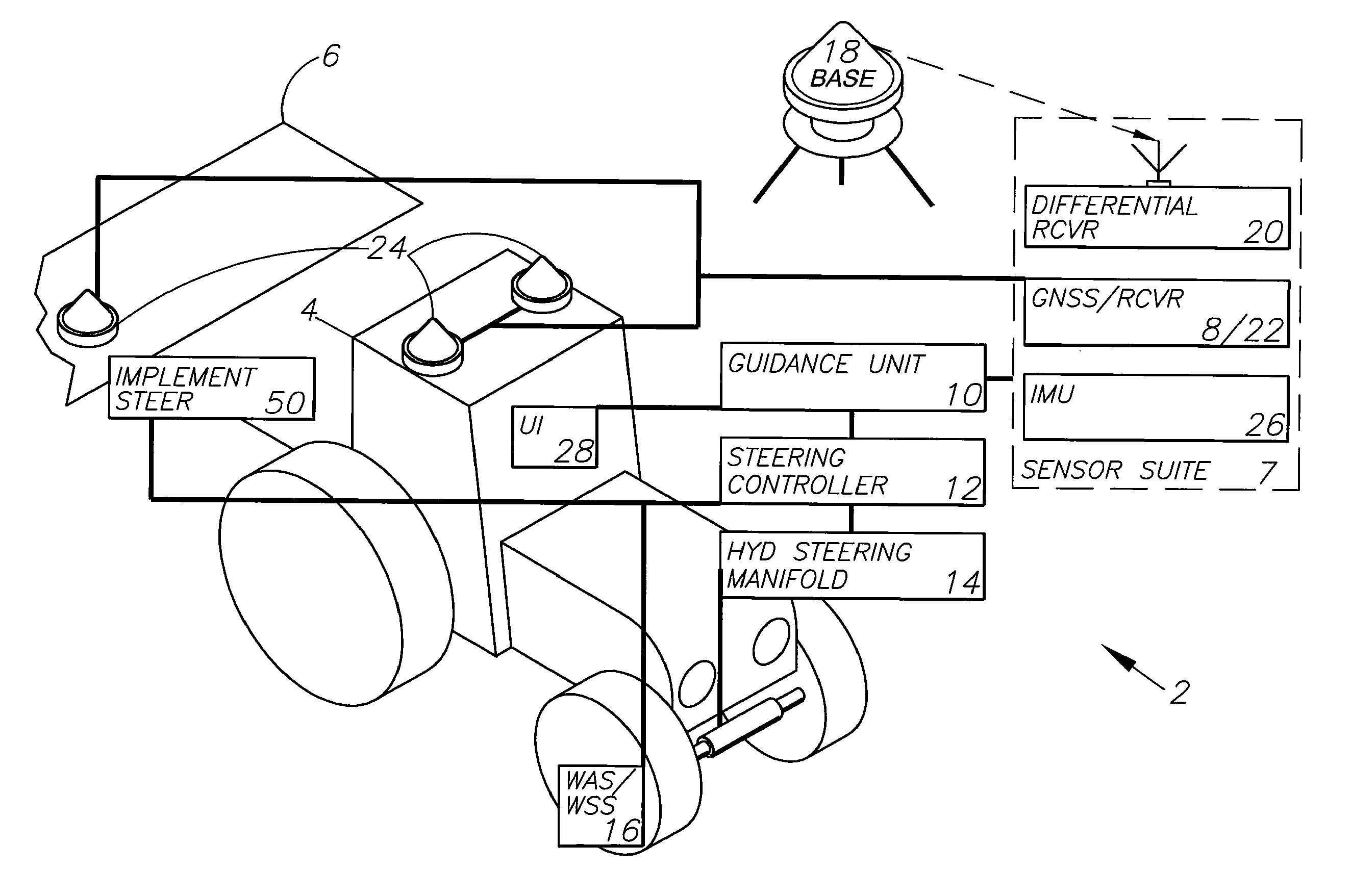
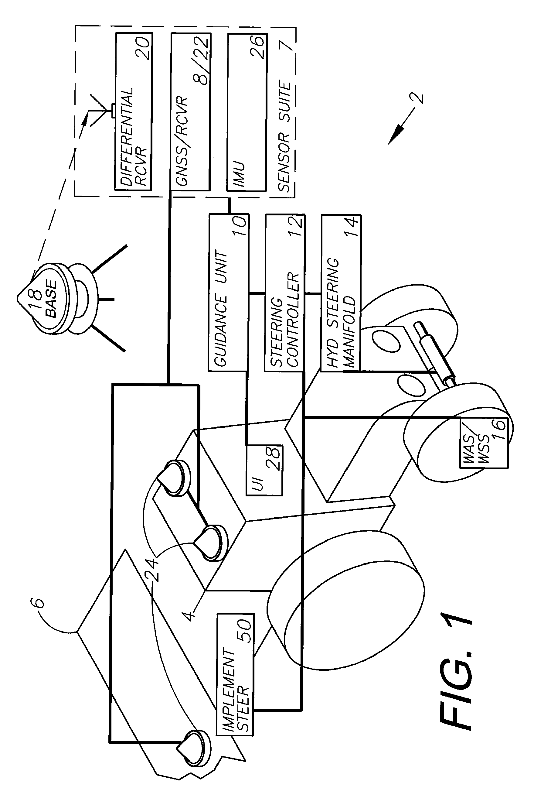
[0031]The preferred embodiment of the integrated multi-sensor guidance system (guidance system) 2, as shown in FIG. 1, includes a vehicle 4, which may be equipped with a farming implement 6, a sensor suite 7, a guidance unit 10 capable of versatile path guidance, a steering controller 12 providin...


PUM


Abstract

A GNSS integrated multi-sensor guidance system for a vehicle assembly includes a suite of sensor units, including a global navigation satellite system (GNSS) sensor unit comprising a receiver and an antenna. An inertial measurement unit (IMU) outputs vehicle dynamic information for combining with the output of the GNSS unit. A controller with a processor receives the outputs of the sensor suite and computes steering solutions, which are utilized by vehicle actuators, including an automatic steering control unit connected to the vehicle steering for guiding the vehicle. The processor is programmed to define multiple behavior-based automatons comprising self-operating entities in the guidance system, which perform respective behaviors using data output from one or more sensor units for achieving the behaviors. A GNSS integrated multi-sensor vehicle guidance method is also disclosed.

Description

CROSS REFERENCE TO RELATED APPLICATION[0001]This application relates to U.S. Provisional Patent Application Ser. No. 61 / 243,417, filed Sep. 17, 2009, filed concurrently herewith, which is incorporated herein by reference.BACKGROUND OF THE INVENTION[0002]1. Field of the Invention[0003]The present invention relates generally to a versatile integrated multi-sensor apparatus which combines positional data from a variety of sensor types including a GNSS system. The various sensor data is ranked according to its confidence level, and using that data as a means to automatically create a planned path and steer a vehicle along that planned path. Elements of the present invention allow the system to be easily interchangeable among a multitude of vehicles and to communicate with other vehicles to allow for autonomous cooperative vehicle behavior building and task delegation.[0004]2. Description of the Related Art[0005]Global navigation satellite system (GNSS) guidance and control are widely us...

Claims


Application Information

Patent Timeline
Patent Type & Authority Patents(United States)
IPC IPC(8): B62D6/00
CPCB62D1/02A01B79/005A01B69/008G05D1/024B62D1/28G05D2201/0201G05D1/0274G05D1/0278G05D1/027G05D1/0257G05D1/0246
Inventor REEVE, DAVID R.JONES, MALCOLM B.RAMM, ANDREAS F.STICHTER, AARON C.GATTIS, JOSHUA M.
Owner AGJUNCTION
Why Eureka
Try Eureka