Method and system for locating and monitoring first responders

a technology for first responders and monitoring systems, applied in traffic control systems, navigation instruments, instruments, etc., can solve the problems of limited accuracy of public gps, gps may not operate indoors, and gps operation and accuracy can be further limited, so as to reduce the number of tracking errors of any single data set or sensor

Active Publication Date: 2014-04-01
TRX SYST
View PDF128 Cites 69 Cited by
  • Summary
  • Abstract
  • Description
  • Claims
  • Application Information

AI Technical Summary

Benefits of technology

The patent describes an Incident Command System that helps to monitor and manage all the people and assets at a scene. It uses a computer and radio to receive data from emergency personnel and sends messages to them. The system also uses different methods to track the location of people and assets, including Inertial Navigation and GPS. It can also use image processing and artificial intelligence to map the information from the navigation system to floor plans. The system also connects all the personnel with an Incident Commander for safety communication. Overall, the system helps to make the incident response more efficient and effective.

Problems solved by technology

However, public GPS operation is limited in its accuracy by design for various reasons, including for national security.
Further, the operation and accuracy of a GPS can be further limited by environmental conditions, for example, urban environments can block or limit GPS satellite signals.
For the same reasons, GPS may not operate indoors.
Such methods are typically limited to low power, line-of-sight transmission of weak signals between a transmitter and receiver and tracking may be compromised by local natural topological features or man-made structures, such as buildings, where weak signals are either obscured or severely attenuated.
While the Global Positioning System (GPS) has proved to be a useful navigation and tracking tool for outdoor tracking of moving vehicles, there are significant limitations when applying GPS to indoor navigation and tracking.
Since GPS relies primarily on a line of sight signal acquisition and tracking, in indoor environments, the line of sight of GPS satellites is substantially obscured and GPS signals are highly attenuated.
As a result, GPS signals are typically several orders of magnitude weaker in building environments than outdoors.
With such weakened signals, GPS receivers have difficulty receiving GPS signals and calculating accurate position information.
Thus far, reliable methods for accurate personal indoor tracking and navigation have been very limited because, unlike vehicle motion, human movement is characteristically complex, non-linear and erratic.
While the NIST report identifies a number of INU devices and methods which have been recently developed for indoor tracking of individuals, the most common tracking methods employed by current workers utilizes dead reckoning navigation techniques which employ a fairly inaccurate method of integrating acceleration data over time.
Due to accelerometer drift error, such tracking methods typically accumulate large amounts of error in a relatively short period of time, dead reckoning methods are inherently unreliable and location tracking must be frequently corrected using fixed waypoints that have a known, pre-determined position.
In addition, for tracking highly non-linear and erratic human movements, such methods are inherently unsuitable since error accumulates too quickly which makes waypoint correction unfeasible.
Furthermore, many of these devices suffer from inaccurate calibration and zero point determination.
However, GPS may not operate indoors.
Furthermore, in many outdoor applications, including urban canyons, GPS can be unreliable.

Method used


Image

  • Method and system for locating and monitoring first responders
  • Method and system for locating and monitoring first responders
  • Method and system for locating and monitoring first responders

Examples


Embodiment Construction

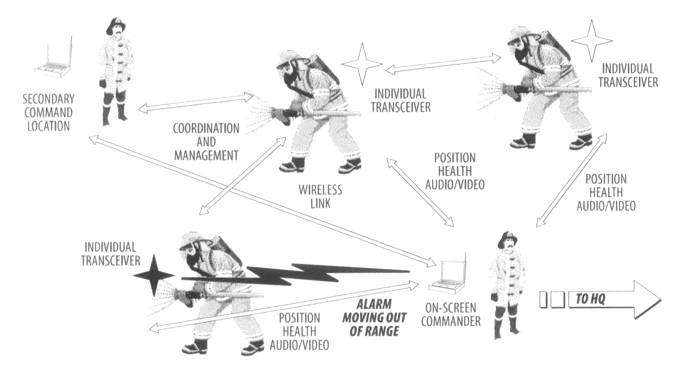
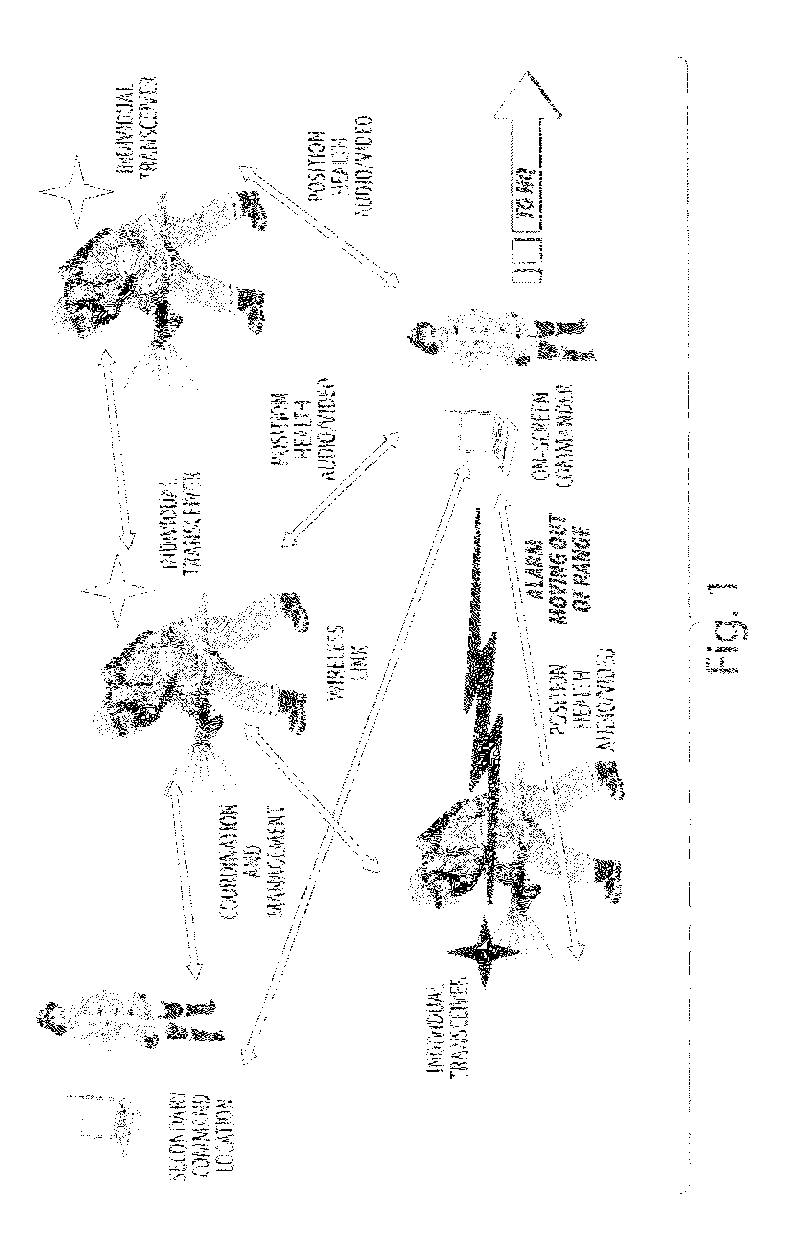
[0061]The present invention can be an integrated solution as shown diagrammatically in FIG. 1. The present invention can provide location and tracking, two-way communications, and data management functions. It can be an open system that can be tailored to a wide variety of applications—for example, applications directed to location, tracking, and status monitoring of personnel and / or assets. As such, in addition to tracking of first responders, it can be adapted to a variety of applications and can be expanded to meet a wide range of requirements, such as location and tracking of people and / or assets in campus environments, VIP status and monitoring, and blue force applications.

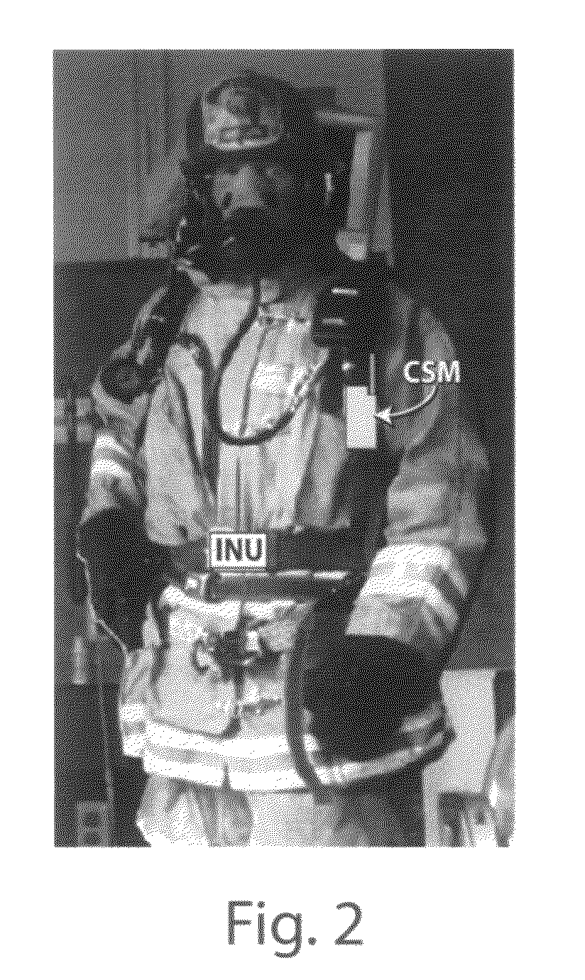
[0062]The systems and methods according to the invention can be used to enable an Emergency Incident or Situation Commander to monitor (for example, remotely from a safe distance) the location, vital signs, and other situational information of first responders including firefighters, police, EMS technicians, ...


PUM


Abstract

The present invention is directed to methods and systems for locating and monitoring the status of people and moveable assets, such as first responders, including firefighters and other public service personnel, and their equipment both indoors and out. The invention can provide for locating and monitoring the status of people and assets in environments where GPS systems do not operate, or where operation is impaired or otherwise limited. The system and method uses inertial navigation to determine the location, motion and orientation of the personnel or assets and communicates with an external monitoring station to receive requests for location, motion orientation and status information and to transmit the location, motion orientation and status information to the monitoring station. The system and method can include storing the location, motion and orientation data as well as status data, in the event that the communication system is unable to communicate with and transmit information to the monitoring station, the system will wait until communication is restored and transmit the status information to the monitoring station to update the location, motion orientation and status information for the person or asset.

Description

CROSS-REFERENCE TO RELATED APPLICATIONS[0001]This Application claims priority to U.S. Provisional Patent Application Ser. No. 60 / 809,900, filed May 31, 2006, and U.S. Provisional Patent Application Ser. No. 60 / 914,032, filed Apr. 25, 2007, each of which is hereby incorporated by reference herein in its entirety.GOVERNMENT RIGHTS[0002]The subject matter disclosed herein was made with government support under award / contract / grant number N41756-04-C-4193 awarded by the Department of Homeland Security, and award / contract / grant number IIP-0750498 awarded by the National Science Foundation. The Government has certain rights in the herein disclosed subject matter.BACKGROUND[0003]1. Technical Field of the Invention[0004]The present invention is directed to methods and systems for locating and monitoring the status of people and moveable assets, such as first responders, including firefighters and other public service personnel, and their equipment both indoors and out. More specifically, th...

Claims


Application Information

Patent Timeline
Patent Type & Authority Patents(United States)
IPC IPC(8): A62C99/00G01C21/00G08G1/123
CPCG01C21/165G01S19/49G08B25/016G08G1/20G01C21/1654
Inventor FUNK, BENJAMIN E.BANDYOPADHYAY, AMRITKOHN, ERIC A.GOLDSMAN, NEILTEOLIS, CAROLE A.BLANKENSHIP, GILMER L.
Owner TRX SYST
Why Eureka
Try Eureka