Adaptive mapping with spatial summaries of sensor data

a sensor data and spatial summary technology, applied in the field of technology, can solve problems such as linear growth of storage requirements

Active Publication Date: 2015-12-22
IROBOT CORP
View PDF152 Cites 30 Cited by
  • Summary
  • Abstract
  • Description
  • Claims
  • Application Information

AI Technical Summary

Benefits of technology

[0008]In accordance with some embodiments of the invention, the robot may map new parameter data to a new local parameter grid or to a pre-existing parameter grid. Data is recorded to a pre-existing parameter grid if the uncertainty between the current robot pose estimate and the pose estimate associated with the pre-existing grid is below a predetermined threshold. By using pre-existing grids, the robot can limit the memory requirements necessary to map the environment without the memory requirements growing linearly in time.

Problems solved by technology

A disadvantage of this system is that all sensor readings and their associated poses must be stored to allow the sensor data to be re-processed when new information arrives.
This results in storage requirements that grow linearly with time.

Method used


Image

  • Adaptive mapping with spatial summaries of sensor data
  • Adaptive mapping with spatial summaries of sensor data
  • Adaptive mapping with spatial summaries of sensor data

Examples


Embodiment Construction

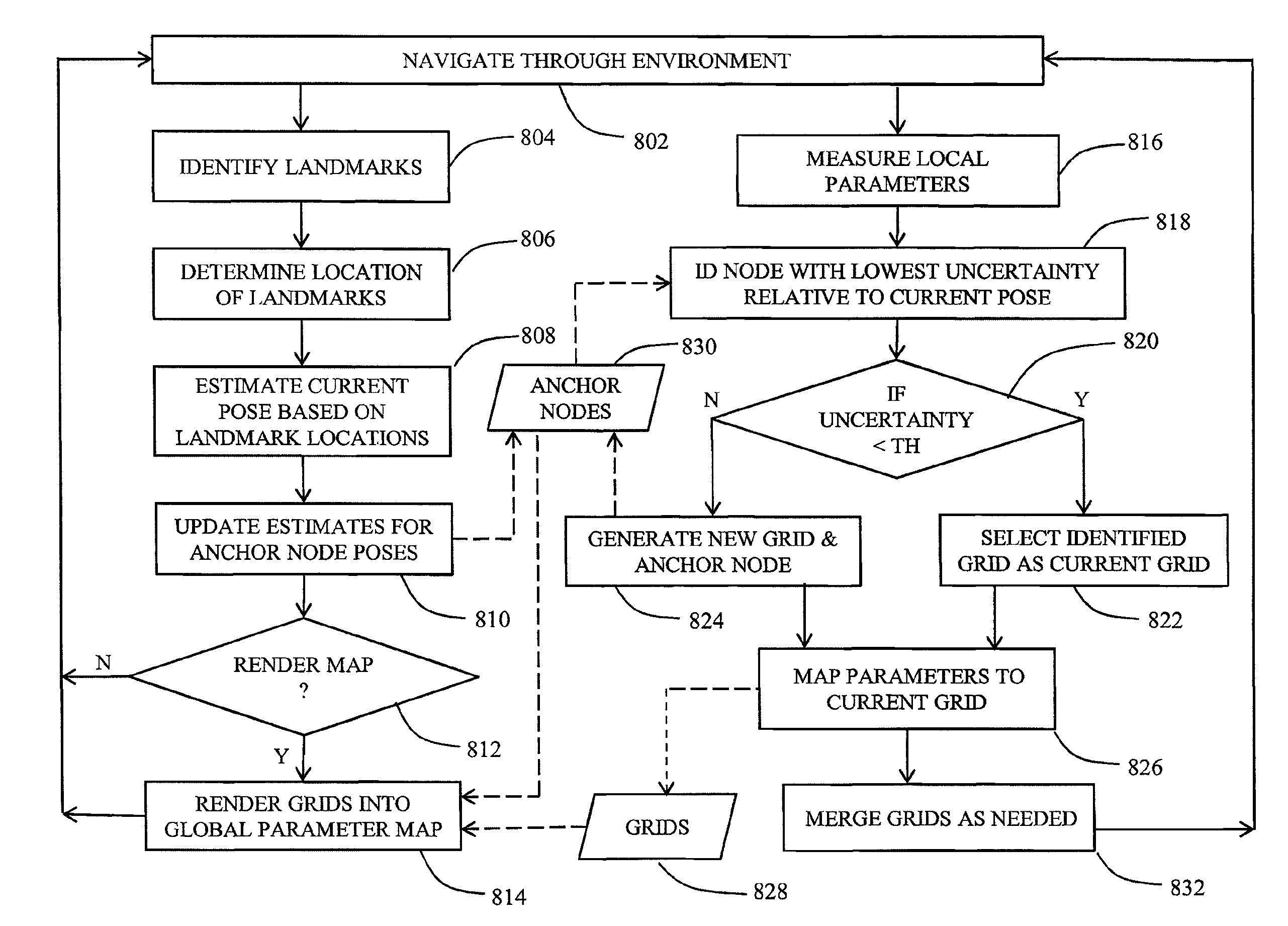
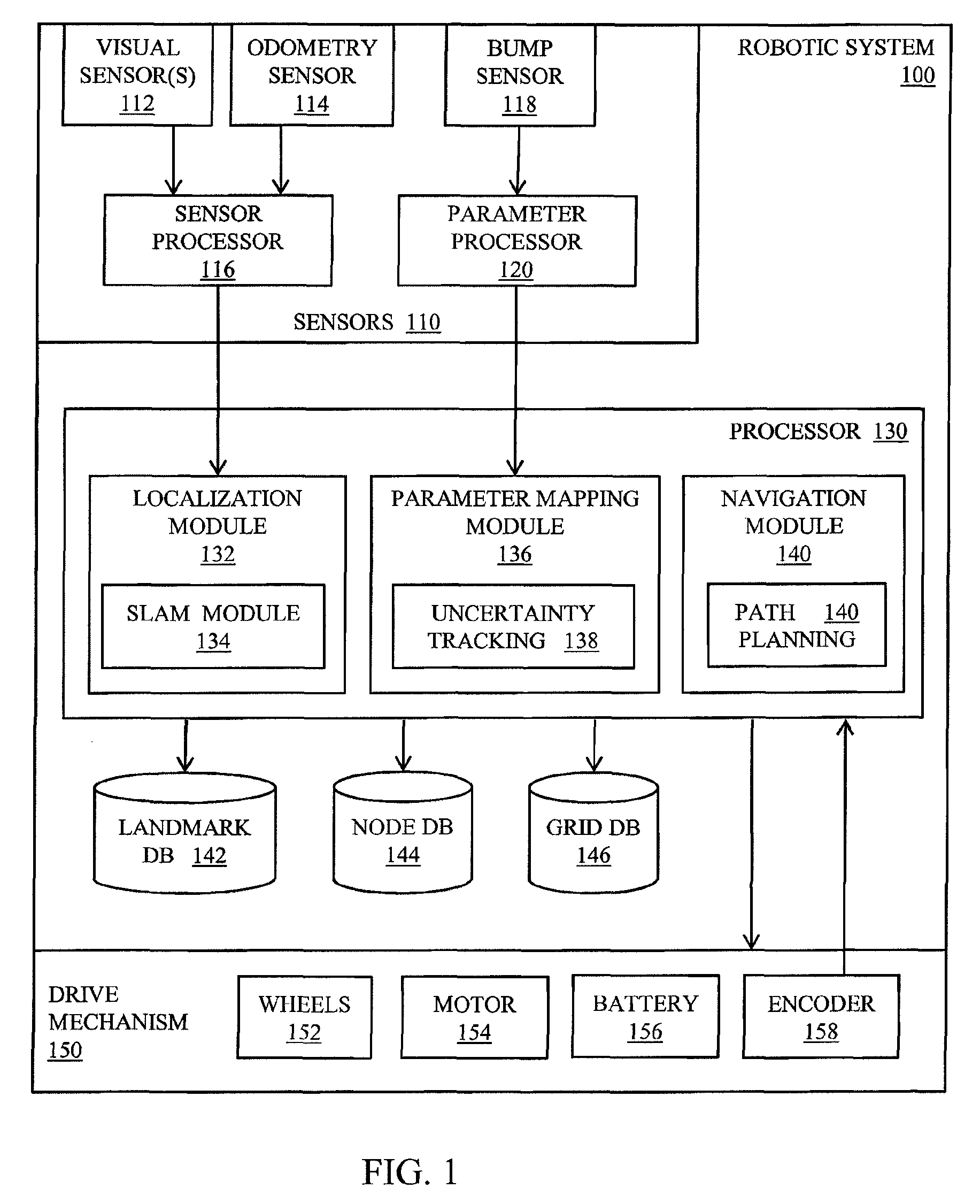
[0024]Illustrated in FIG. 1 is a functional block diagram of a mobile robotic system configured to generate spatial summaries as described in more detail below. The robotic system 100 includes one or more sensors 110, a central processing unit 130, one or more databases for storing relevant data, and a drive mechanism 150 including drive wheels 152, for example. The one or more sensors 110 include one or more visual sensors 112, i.e., cameras, video cameras, imagers including CCD imagers, CMOS imagers, and infrared imagers, for example, for acquiring images of the environment in which the robot is roving. The set of sensors in the preferred embodiment also includes one or more wheel odometers 158 for measuring the rotation of the wheels of the drive system. The set of sensors may further include one or more bump sensors 118 for generating a signal indicating the presence of an obstacle in the path of the mobile robot.

[0025]Data from the sensors 112, 114 may undergo preprocessing at ...


PUM


Abstract

A system and method for mapping parameter data acquired by a robot mapping system is disclosed. Parameter data characterizing the environment is collected while the robot localizes itself within the environment using landmarks. Parameter data is recorded in a plurality of local grids, i.e., sub-maps associated with the robot position and orientation when the data was collected. The robot is configured to generate new grids or reuse existing grids depending on the robot's current pose, the pose associated with other grids, and the uncertainty of these relative pose estimates. The pose estimates associated with the grids are updated over time as the robot refines its estimates of the locations of landmarks from which determines its pose in the environment. Occupancy maps or other global parameter maps may be generated by rendering local grids into a comprehensive map indicating the parameter data in a global reference frame extending the dimensions of the environment.

Description

CROSS-REFERENCE TO RELATED APPLICATIONS[0001]This is a continuation of U.S. patent application Ser. No. 13 / 632,997, filed Oct. 1, 2012, which claims the benefit of U.S. Provisional Patent Application Ser. No. 61 / 541,749 filed Sep. 30, 2012, titled “Adaptive mapping with spatial summaries of sensor data,” the contents of which are incorporated herein by reference in their entirety.BACKGROUND OF THE INVENTION[0002]1. Field of the Invention[0003]The invention relates to a technique for generating a map of an environment using a plurality of sub-maps. In particular, the invention relates to a system and method for combining sensor data into a plurality of sub-maps based upon the location of the sensor when the data was acquired and the certainty with its location was known.[0004]2. Description of the Related Art[0005]In the past few years, a substantial research effort has been devoted to the problem of Simultaneous Localization and Mapping (SLAM). The term “map” in the field of SLAM ge...

Claims


Application Information

Patent Timeline
Patent Type & Authority Patents(United States)
IPC IPC(8): G05B15/00G05D1/02
CPCG05D1/0274G05D2201/0216G01C21/20G05D1/0246G01C21/3881G05B15/00Y10S901/00G01C21/206G05D1/0088G05D1/0238
Inventor FONG, PHILIPEADE, ETHANMUNICH, MARIO E.
Owner IROBOT CORP
Why Eureka
Try Eureka