Update method of mobile object location based on traffic network and GPS

A technology for moving objects and updating methods, applied in the field of mobile computing, can solve the problems of increasing the cost of communication and calculation, difficult to overcome processing accuracy and communication cost, processing efficiency, and difficulty in managing moving objects.

Inactive Publication Date: 2008-02-20
INST OF SOFTWARE - CHINESE ACAD OF SCI
View PDF0 Cites 24 Cited by
  • Summary
  • Abstract
  • Description
  • Claims
  • Application Information

AI Technical Summary

Problems solved by technology

All of the above running vector based methods lead to multiple unnecessary location updates at intersections, increasing the communication and computation cost
[0006] From the above analysis, it can be seen that almost all current location update methods do not fully consider the interaction relationship between the mobile object and the traffic network, and it is difficult to overcome the contradiction between processing accuracy, communication cost and processing efficiency, thus giving the mobile object management poses difficulties

Method used


Image

  • Update method of mobile object location based on traffic network and GPS
  • Update method of mobile object location based on traffic network and GPS
  • Update method of mobile object location based on traffic network and GPS

Examples


example 1

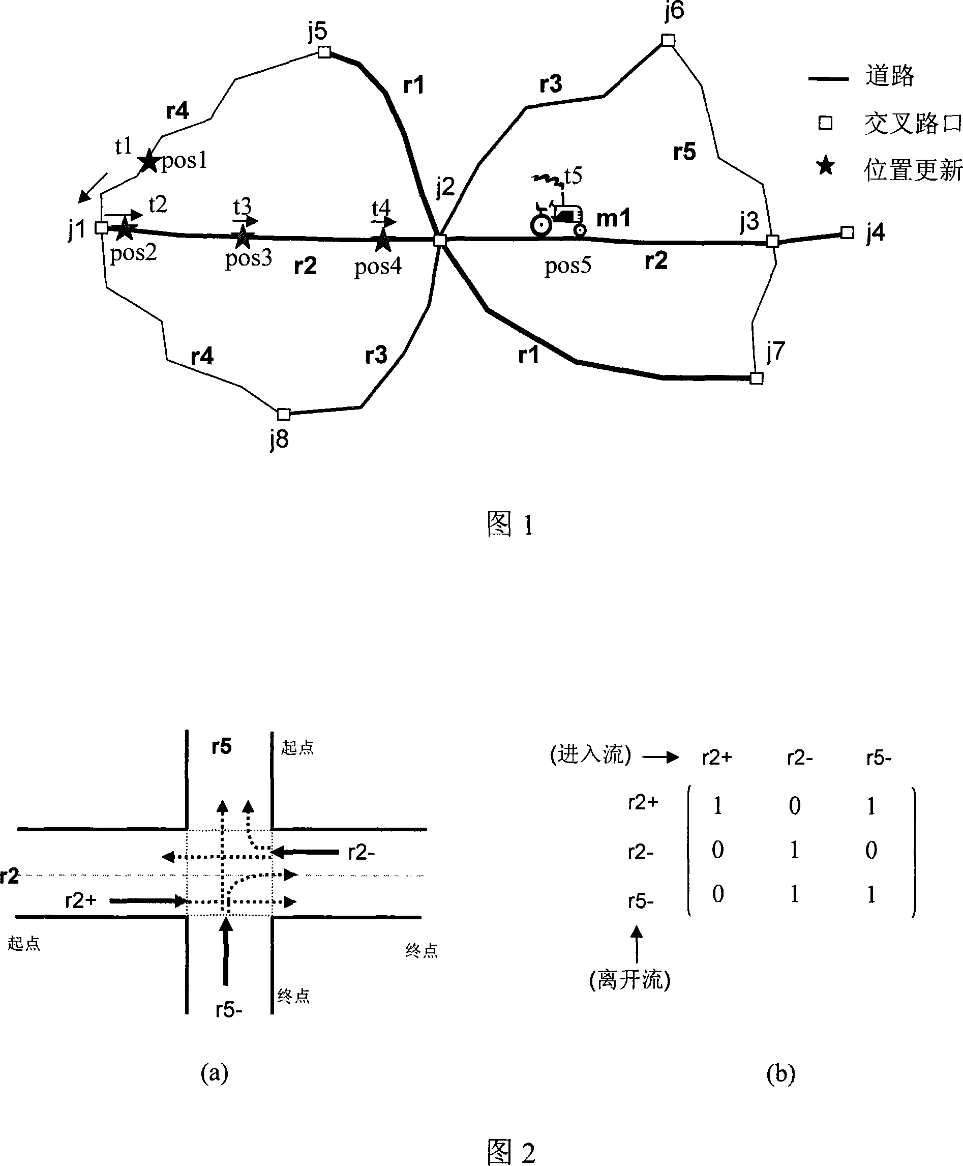
[0045] Take the traffic road network shown in Figure 1 and the running track of a moving object m1 as an example, the broken line in Figure 1 represents the road, there are 5 roads in total, and the corresponding road IDs are r1, r2, r3, r4, r5; The box represents the intersection, and there are 8 intersections, represented by j1, j2.....j8 respectively; pos1, pos2...pos5 represent the moving object m1 at time t1, t2,..... .t5 (where t5 is the current moment), and the five-pointed star indicates that the location has been updated at this moment.

[0046] Assume that at time t1, the running vector of the moving object m1 is (t1, (r4, pos1), 55, -). At time t2, the moving object m1 uses the GPS device to obtain its running status, where the position coordinates are (96, 57), the speed is 54 km / h, and the running direction is positive, that is, +. According to the traffic road network data, it can be seen that the coordinate position (96, 57) is located on the road r2, and then ...

example 2

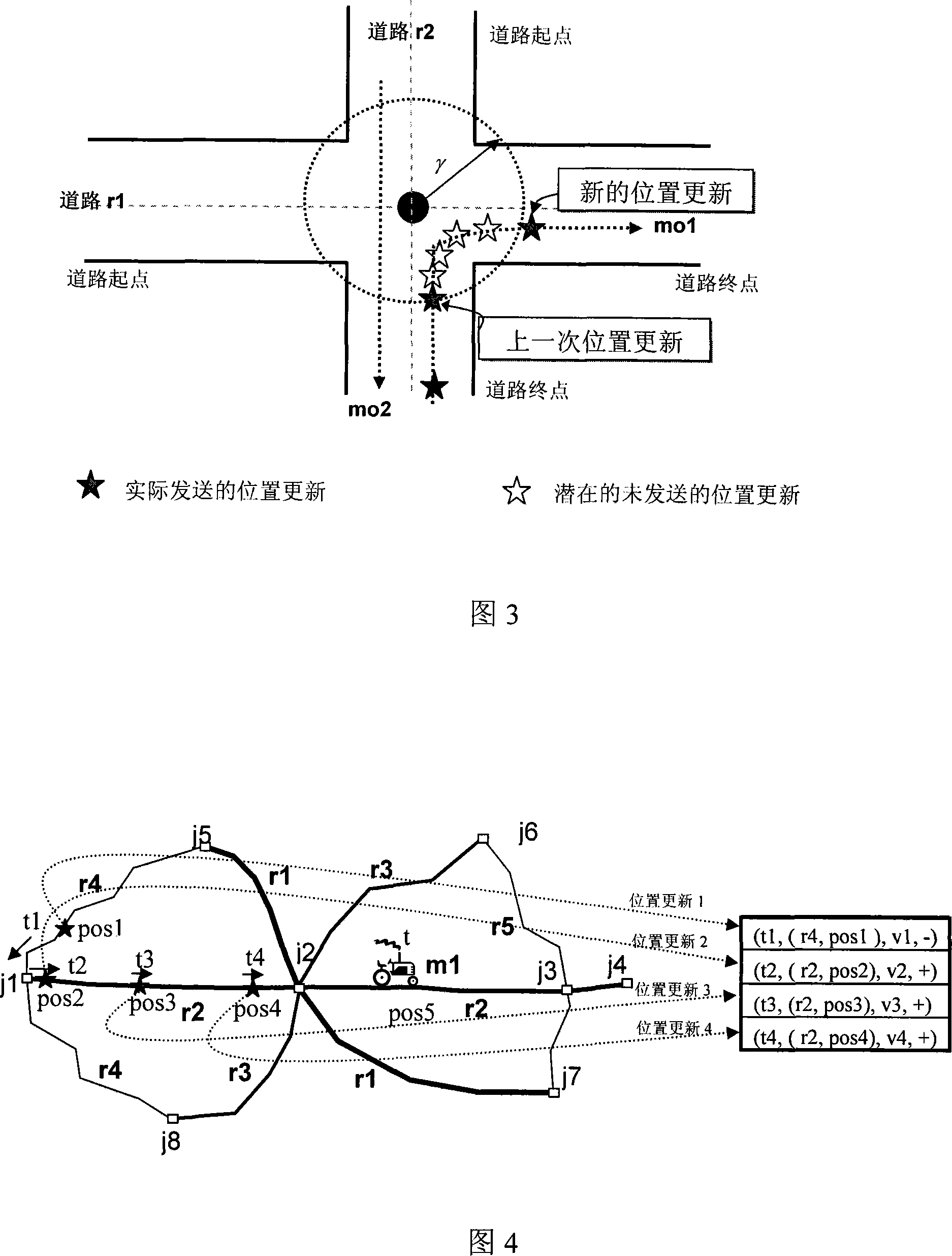
[0051] Another example is given below to illustrate the special processing of the present invention for updating the position of intersections. As shown in FIG. 3 , the intersection area of ​​roads r1 and r2 is a circular area with a radius of γ delineated by a dotted line. The mobile object mo1 crosses the intersection and runs from road r2 to road r1, and performs a position update when it just enters the intersection area (see "Last position update" in Figure 3). A location update message, after that, when it is in the intersection, even if it meets other location update conditions, it will no longer send location update information (see the five-pointed star with white background and black border in Figure 3), until it drives out of the intersection The intersection area only sends a new location update information (see "new location update" in Fig. 3).

[0052] In Figure 3, the mobile object mo2 passes through the intersection at a relatively steady speed. Since it is st...


PUM


Abstract

The utility model discloses an updating method for a moving object based on the road transportation network and GPS, aiming at enabling a central server to trace the former and current position of the moving objects. The utility model is characterized in that the moving object uses GPS to measure the latest running data continuously, through matching with the transportation network, the coordinate of the latitude and the longitude and the direction data are converted into the data format based on the road network, then the current running vector is compared with the running data submitted by the updating on the last position according to the principle of the inertia, and the position updating condition is determined, the current running vector of the moving object is reported to the central server only when the moving object does not keep running as the principle of the inertia. Additionally, the utility model optimizes the updating of the position in the road crossing, only one time position updating of the moving object is performed at most in the road crossing. The utility model has advantages of reducing the communication frequency and improving the data processing efficiency under the premises of securing the processing precision compared with the prior art.

Description

technical field [0001] The invention relates to a method for individual mobile objects to report their own position, speed, direction and other information to a central server in the field of mobile computing, and to enable the central server to track the past and current positions of the mobile object throughout the process. Background technique [0002] In the past ten years, mobile computing technology has developed rapidly. More and more applications require the management of the dynamic location of moving objects (such as cars, airplanes, ships, mobile users, etc.), and one of the core problems that needs to be solved is how the central server can efficiently, accurately and timely obtain the location of moving objects. The latest location information. The location tracking mechanism is usually to install some kind of positioning device (such as the global positioning system GPS) on the moving object. Through the wireless communication interface and a certain location ...

Claims


Application Information

Patent Timeline
Patent Type & Authority Applications(China)
IPC IPC(8): H04Q7/38G01S1/02G01S5/02H04W4/02H04W64/00
Inventor 丁治明
Owner INST OF SOFTWARE - CHINESE ACAD OF SCI
Why Eureka
Try Eureka