Highway measuring and setting method based on three-dimensional airborne LIDAR

A three-dimensional machine and highway technology, which is applied to the road measurement and design based on airborne LIDAR technology, and the field of road measurement and design based on 3D airborne LIDAR, can solve the problems of long measurement and design cycle, shortening, and large field workload. The effect of loosening the sun altitude angle, reducing intermediate processes, reducing field workload and operating costs

Active Publication Date: 2008-04-09
CCCC SECOND HIGHWAY CONSULTANTS CO LTD
View PDF0 Cites 53 Cited by
  • Summary
  • Abstract
  • Description
  • Claims
  • Application Information

AI Technical Summary

Problems solved by technology

[0004] The purpose of the present invention is to propose a road survey and design method based on three-dimensional airborne LIDAR, aiming at the limitations of the road survey and design mode based on aerial photogrammetry in the current difficult and complex areas, such as long survey and design cycle and large field workload. The method is simple, the operation is convenient, the direct use of LIDAR data can meet the requirements of traffic engineering construction detailed survey and construction drawing design, which greatly improves the efficiency of survey and design, shortens the survey and design cycle, and has significant economic and social benefits

Method used


Image

  • Highway measuring and setting method based on three-dimensional airborne LIDAR
  • Highway measuring and setting method based on three-dimensional airborne LIDAR
  • Highway measuring and setting method based on three-dimensional airborne LIDAR

Examples


Embodiment 1

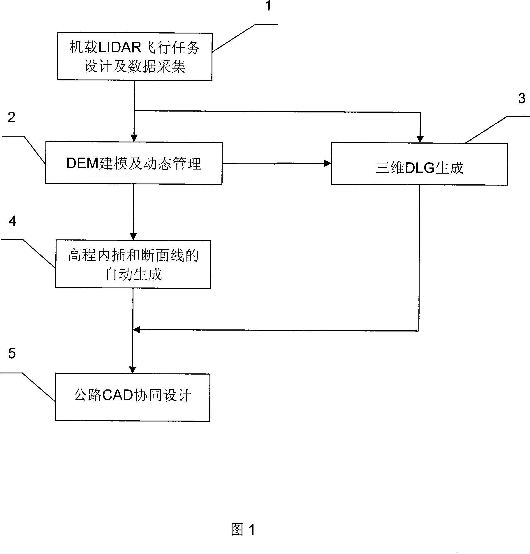
[0024] The following describes the implementation of the present invention with the aid of the accompanying drawings. The specific workflow is shown in FIG. 1 and described as follows.

[0025] The first step, airborne LIDAR mission design and LIDAR data collection 1

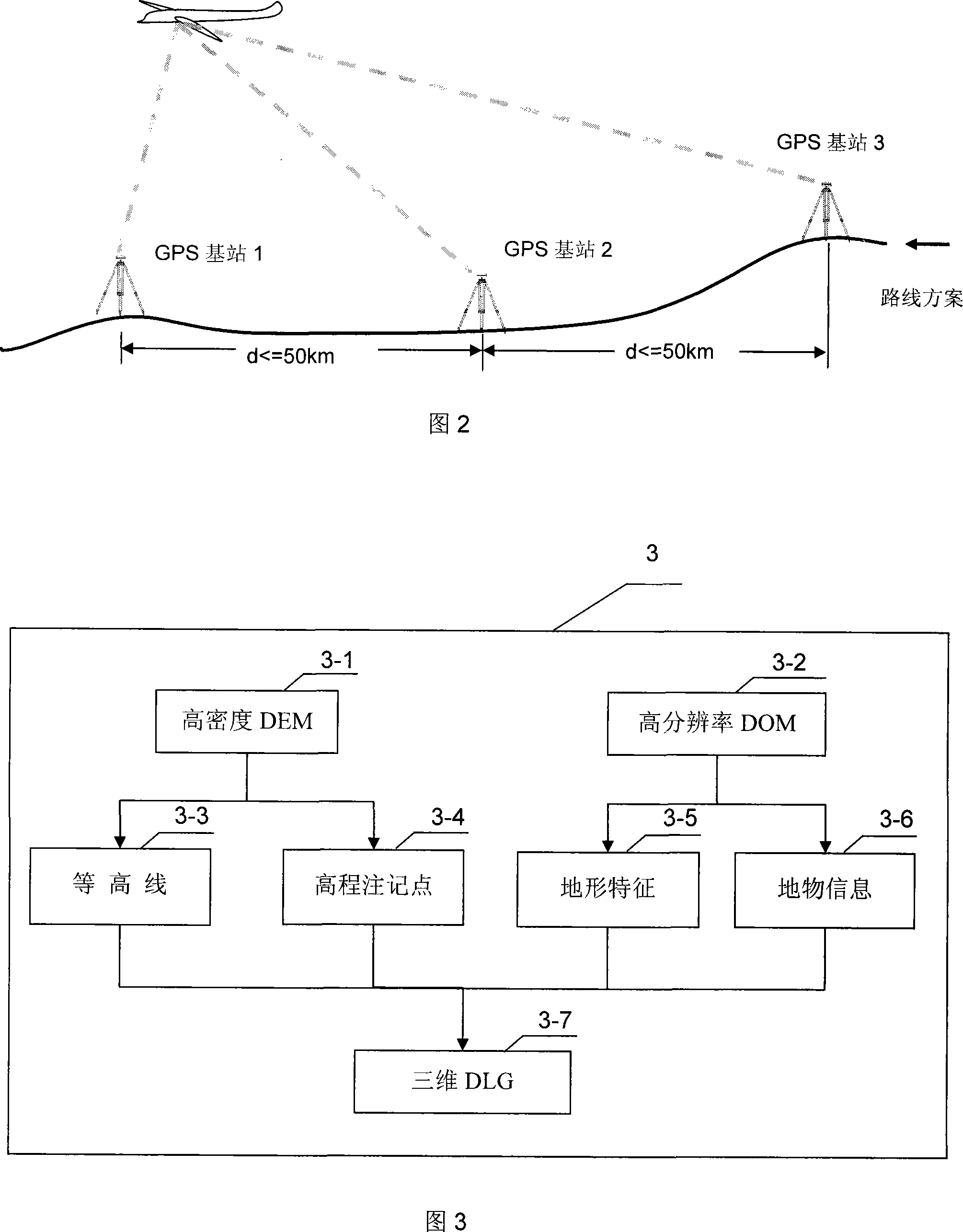
[0026] According to the start and end points of the design route, the airborne LIDAR flight mission design and LIDAR data collection are carried out. Its implementation of the standards and norms are:

[0027] ■1:10000, 1;50000 Topographic Map IMU / DGPS Aided Aerial Photography Technical Regulations (Trial), December 2004, State Bureau of Surveying and Mapping

[0028] ■GPS Aided Aerial Photography Technical Regulations (Trial), December 2004, State Bureau of Surveying and Mapping

[0029] ■GB 6962-86 "1:500, 1:1000, 1:2000 Scale Topographic Map Aerial Photography Specification", December 1986, State Bureau of Surveying and Mapping

[0030] ■GB / T16341-2001 Highway Global Positioning System (GPS) Measurement Sp...


PUM


Abstract

The invention discloses a road measurement method based on 3D plane-carried LIDAR. The steps include: firstly, constructing GPS base stations in a measurement area and setting technical parameters based on a road design proposal by employing a ground data collection system and taking a plane as a platform; secondly, building a database of a large amount of high density DEM data, and performing dynamic block management on the database via a range index file to satisfy rapid scheduling of required data in design procedure; thirdly, generating a 3D DLG based on DEM and DOM; fourthly, generating ground broken section data satisfying road measurement and design requirement of construction blueprint; and fifthly, realizing 3D visibility and dynamic design based on combination of plane-carried LIDAR and road CAD to automatically generate various design schemes and construction blueprints. The inventive method has the advantages of simple and convenient operation, directly-realized road measurement and construction blueprint design based on data generated by a plane-carried LIDAR, reduced external field work flow, shortened measurement and design period, and greatly increased measurement and design efficiency.

Description

technical field [0001] The invention relates to the technical field of road surveying and design, and more specifically relates to a road surveying and designing method based on three-dimensional airborne LIDAR, which is suitable for road surveying and designing methods based on airborne LIDAR technology in areas with difficult and complex surfaces. Background technique [0002] At present, the main means and methods of road surveying and design are based on aerial photogrammetry surveying and design mode, that is, obtaining ground stereoscopic images through low-altitude aerial photography, developing and scanning photo negatives (or directly obtaining digital photos with CCD cameras), combined with artificial layout field Ground highway basic control network and photogrammetry photo control points are processed by photogrammetry workstations, and a large number of manual in-house productions are used to obtain DEM, DLG, DOM and other products. On this basis, highway CAD aid...

Claims


Application Information

Patent Timeline
Patent Type & Authority Applications(China)
IPC IPC(8): G06T17/40G01C11/00G01S17/08G06T19/00
Inventor 陈楚江王丽园余绍淮张霄
Owner CCCC SECOND HIGHWAY CONSULTANTS CO LTD
Why Eureka
Try Eureka