
Method for ground surface temperature and emissivity inversion by remote sensing data ASTER

A technology of surface temperature and remote sensing data, applied in the direction of using re-radiation, ICT adaptation, electromagnetic wave re-radiation, etc., to achieve the effect of improving technical support, simple operation and reducing unknowns

Inactive Publication Date: 2008-10-29
INST OF AGRI RESOURCES & REGIONAL PLANNING CHINESE ACADEMY OF AGRI SCI
View PDF0 Cites 36 Cited by
  • Summary
  • Abstract
  • Description
  • Claims
  • Application Information

AI Technical Summary

Problems solved by technology

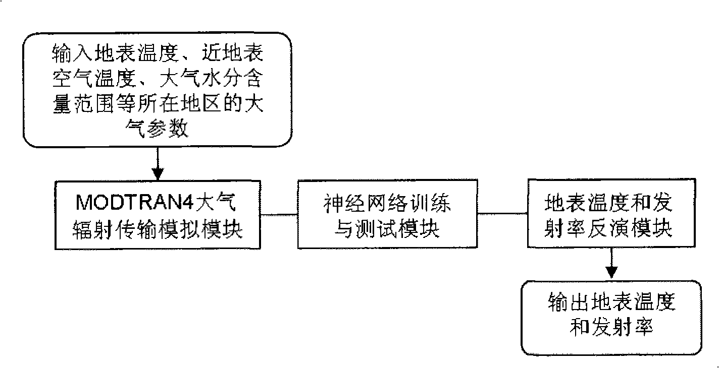
[0010] The purpose of the present invention is to provide a method for retrieving surface temperature and emissivity from remote sensing data ASTER, to overcome the shortcomings of the existing inversion algorithm for simultaneously inverting surface temperature and emissivity products for ASTER data

Method used


Image

  • Method for ground surface temperature and emissivity inversion by remote sensing data ASTER
  • Method for ground surface temperature and emissivity inversion by remote sensing data ASTER
  • Method for ground surface temperature and emissivity inversion by remote sensing data ASTER

Examples


Embodiment Construction

[0046] The surface temperature inversion is based on the surface heat radiation conduction equation, that is, the surface temperature is inverted by establishing an energy balance equation. The radiative transfer equation describes the total intensity of radiation observed by the satellite's microwave radiometer, not only from the surface, but also from the atmosphere on its upward and downward paths. In the process of passing through the atmosphere to the remote sensor, these radiation components are also reduced by the absorption effect of the atmosphere. At the same time, the radiation from the surface and the atmosphere also has a non-negligible impact in this process. The inversion formula of surface temperature can be simplified as Equation 1:

[0047] B i (T i )=ε i (θ)τ i (θ)B i (T s )+[1-τ i (θ)][1+(1-ε i (θ))τ i (θ)]B i (T ia ) (Formula 1)

[0048] In formula 1: τ i (θ) represents the transmittance of the i-band (i is the 10th, 11th, 12th, 13th, and ...


PUM


Abstract

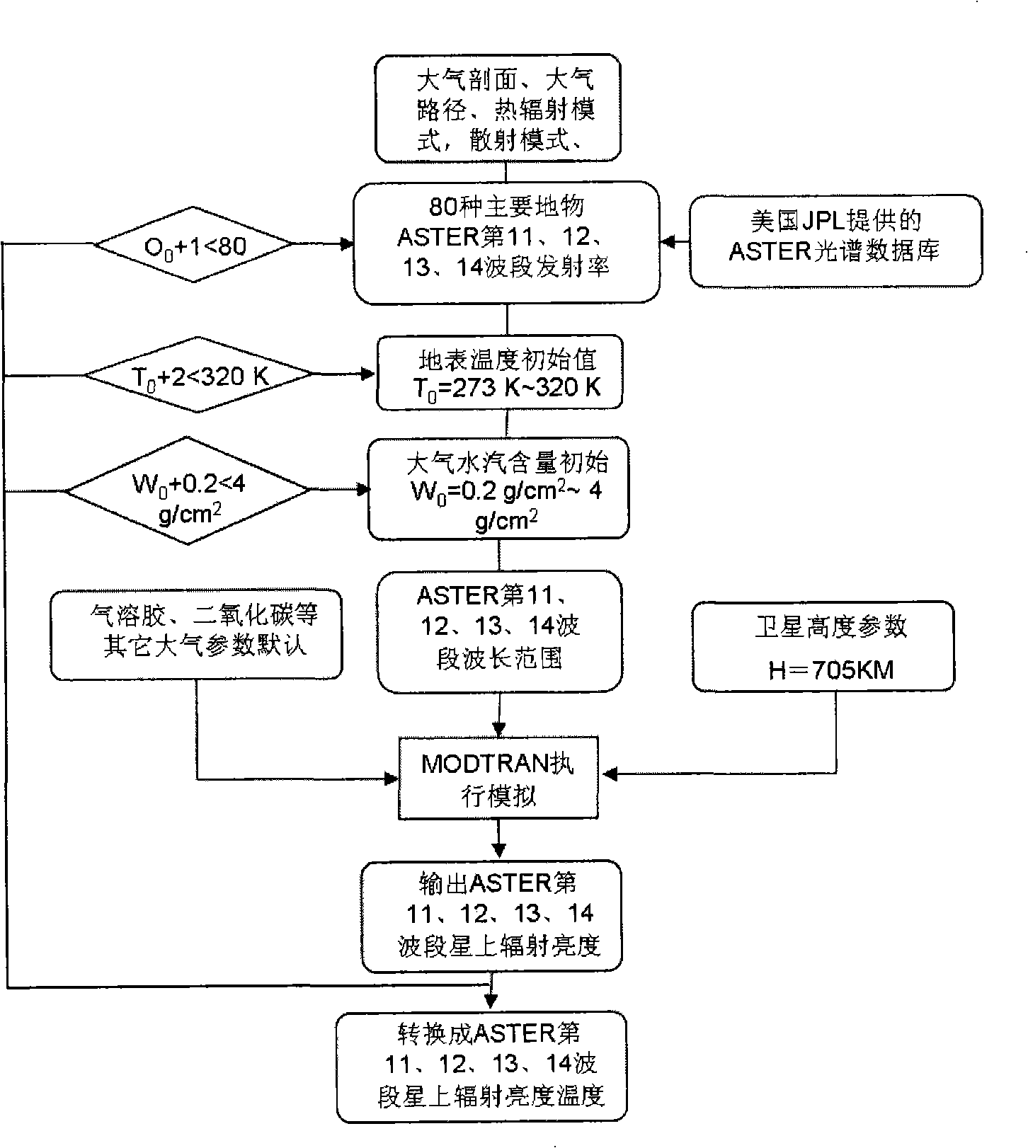
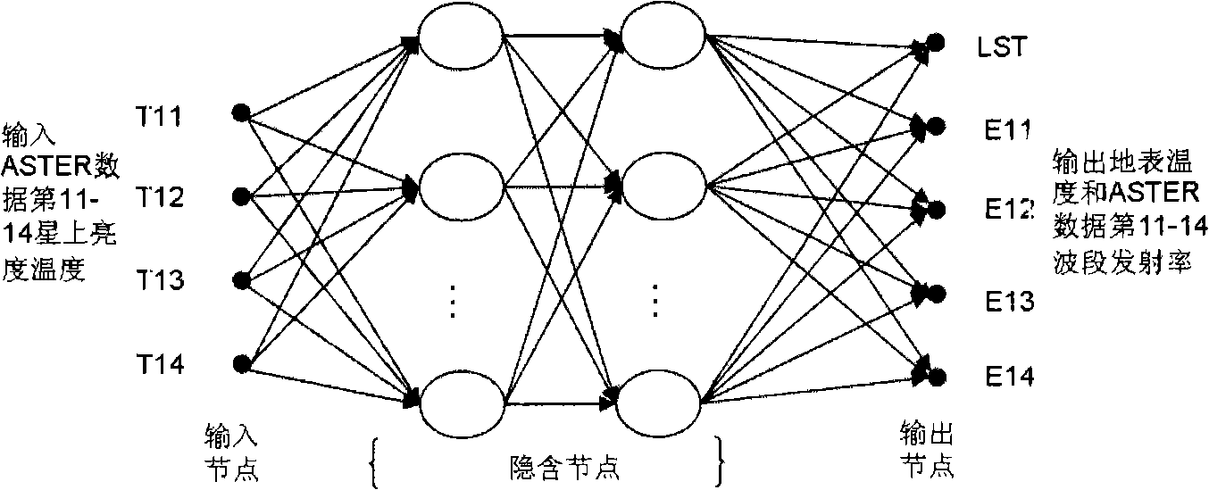
The invention relates to a method for inverting surface temperature and emissivity from remote sensing data ASTER, comprising three steps: step one: a training and testing database is established by utilizing that an atmospherical radiation transmission simulating software carries out positive simulation aiming at the areas and seasons of the 11th, 12th, 13th and 15th thermal infrared wave bands of the obtained thermal sensing data ASTER and an atmospherical model; step two: a neural network is utilized for carrying out repeated training and test to a training and testing data set; step three: inversion calculation is carried out to the ASTER actual image data, and actual earth surface verification and application analysis are carried out. The products obtained by the method have high precision, especially when the surrounding atmospherical changes greatly.

Description

technical field [0001] The invention relates to a method for simultaneously inverting surface temperature and emissivity from remote sensing data ASTER, which can be applied to remote sensing departments such as meteorology, environmental monitoring, land management, agricultural condition monitoring, and national defense and military affairs. Background technique [0002] In 1999, the Earth Observation Satellite (TERRA) equipped with the ASTER (Advanced Spaceborne Thermal Emission and Reflection Radiometer) remote sensor was successfully launched, opening up a new way for the dynamic monitoring of global and regional resources and environment. ASTER is provided by Japan's Ministry of International Trade and Industry (METI), and is mainly used to solve problems in several aspects such as land use and cover, natural disasters, short-term weather changes, and hydrology. The orbit height is 705KM. It is a sun-synchronous near-polar orbit. The operation period is 98.88 minutes. ...

Claims


Application Information

Patent Timeline
IPC IPC(8): G01S17/95G01S17/88G01S7/48G01S7/497G06N3/02
CPCY02A90/10
Inventor 毛克彪唐华俊周清波王秀峰王道龙苏胜娣
Owner INST OF AGRI RESOURCES & REGIONAL PLANNING CHINESE ACADEMY OF AGRI SCI
Learn More