Accurate train positioning method and system realized by digital trail map and GPS

A train positioning and track technology, applied in railway signaling and safety, etc., can solve problems such as map matching defects, limiting train positioning accuracy and stability, and map matching method failure.

Active Publication Date: 2009-02-04
BEIJING JIAOTONG UNIV
View PDF0 Cites 40 Cited by
  • Summary
  • Abstract
  • Description
  • Claims
  • Application Information

AI Technical Summary

Problems solved by technology

[0005] (2) Defects in map matching
However, the map matching method does not participate in the positioning calculation process but directly relies on the autonomous positioning resul

Method used


Image

  • Accurate train positioning method and system realized by digital trail map and GPS
  • Accurate train positioning method and system realized by digital trail map and GPS
  • Accurate train positioning method and system realized by digital trail map and GPS

Examples


Embodiment 1

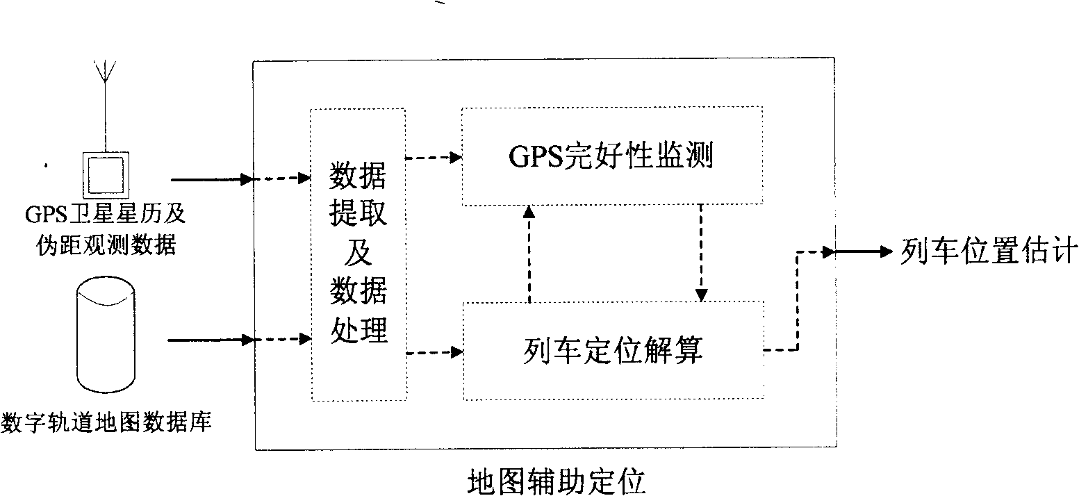
[0085] Embodiment 1: as figure 1 As shown, the core of the digital track map-assisted train positioning method studied in the present invention is the map-assisted train positioning algorithm. The map-assisted train positioning system can be roughly divided into three modules: data extraction and processing, GPS integrity monitoring and train positioning calculation. These three modules, although structurally independent, are interrelated in each computing cycle. The map-assisted train positioning system includes two main sub-algorithms, the digital track map-assisted GPS integrity monitoring algorithm and the train positioning solution algorithm. The input of the system includes: observation data such as satellite ephemeris and pseudorange from GPS receivers, and a digital orbit map database containing precise geographic information of orbits. The output of the system is an estimate of the train's position.

Embodiment 2

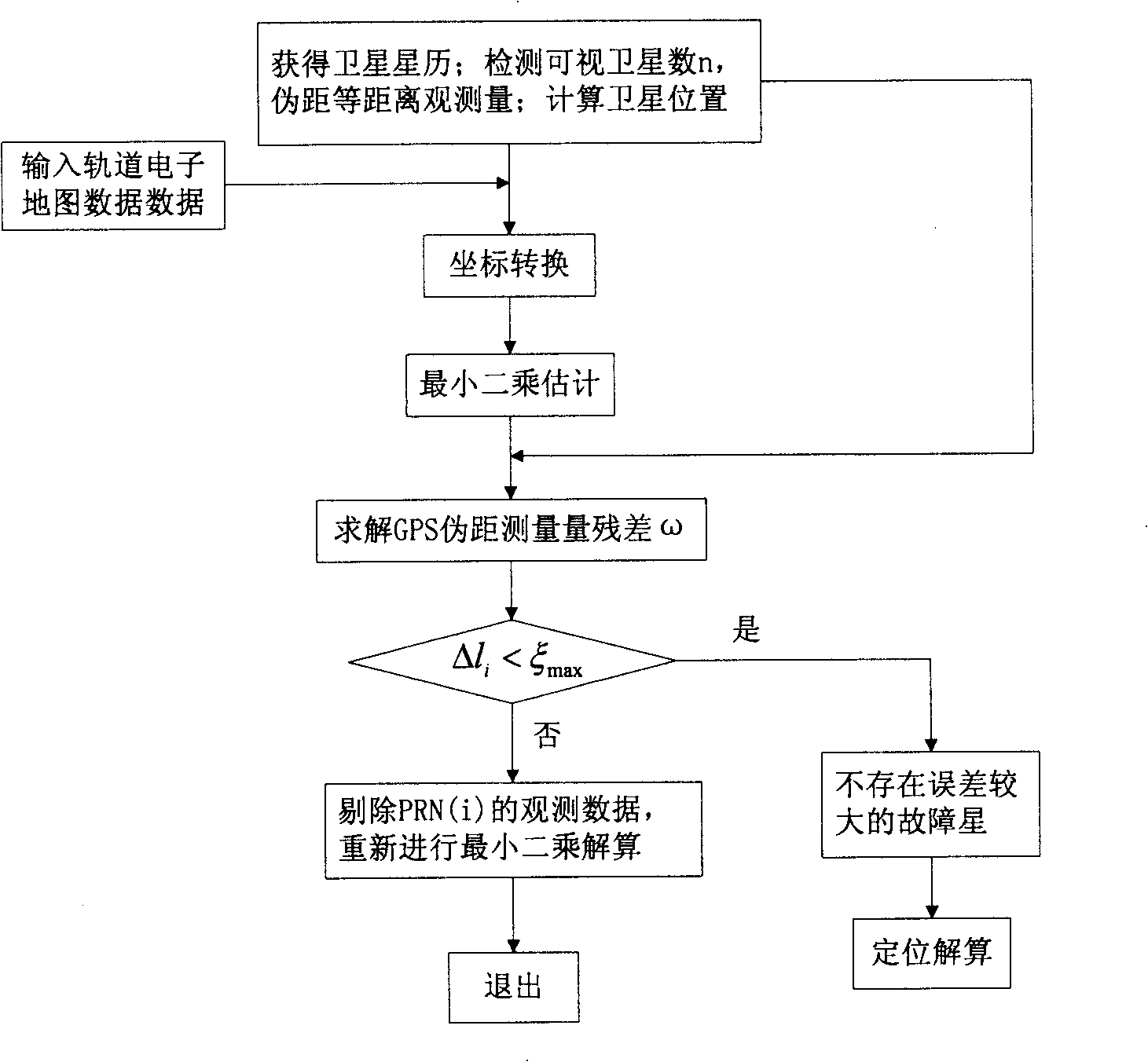
[0086] Embodiment 2 is attached figure 2 As shown, the present invention is further described in detail through specific embodiments. In one embodiment, the specific flow of the GPS integrity monitoring algorithm assisted by the digital track map according to the present invention is as follows:

[0087] 1. Collect ephemeris data and pseudo-range observations of visible satellites, and calculate the position coordinates of visible satellites. Specifically, the NovAtel GPS receiver is used to collect the ephemeris data and pseudo-range observation data of the visible satellites, and extract the relevant parameters in the satellite ephemeris to calculate the position coordinates of the visible satellites;

[0088]2. Extraction and processing of track map information. In one embodiment, the train lane occupancy information is obtained by the station interlocking system, the map information of the corresponding lane is extracted from the track map database, and these map inform...

Embodiment 3

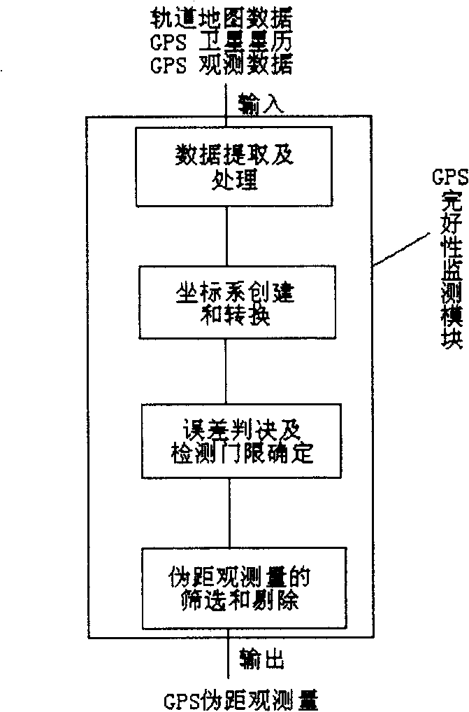
[0092] Embodiment 3 is attached image 3 As shown, the GPS integrity monitoring algorithm of the present invention can be summed up and described as following 4 main submodules: data extraction and processing module, data extraction and data processing module are used for extracting and processing satellite ephemeris and pseudorange from GPS receiver Observational data, as well as data input from the digital orbit map database containing precise orbital geographic information; and calculate the position coordinates of visible satellites and be responsible for the extraction and processing of orbit map information; the processed data is input into the GPS integrity monitoring module , the GPS monitoring module is responsible for establishing a local coordinate system based on the track line, and converting the train position from WGS-84 coordinates to a new local coordinate system based on the track; the error judgment and detection threshold determination module is responsible ...


PUM


Abstract

The invention provides a method for realizing accurate train positioning by a GPS with the aid of a digital railway map. The train positioning method essentially comprises two subalgorithms, namely a GPS integrity monitoring algorithm and a train positioning calculating algorithm. The GPS integrity monitoring algorithm uses the establishment of a local coordinate system based on railways and transforms a WGS-84 coordinate to a new local coordinate system based on railways as well as uses geographic information provided by the digital railway map to establish a redundancy equation and a constraint condition so as to monitor the pseudo-range observed quantity of the GPS; the train positioning calculating algorithm is responsible for establishing a train position calculating model and a speed calculating model and integrating the two models to realize a train positioning calculating function. The train positioning method, provided by the invention, can not only effectively improve the precision and the stability of the train positioning when the GPS is complete, but also provide a train positioning result with comparatively high precision when the GPS is not complete.

Description

technical field [0001] The invention belongs to the technical field of vehicle positioning, and in particular relates to a method and system for realizing accurate train positioning by using a digital track map to assist GPS. Background technique [0002] With the rapid growth of the global economy, railway transportation plays an increasingly important role in the growth of the national economy. The greater the transport capacity of railway trains, the greater the number and the faster the speed, the higher the safety requirements for train operation. The real-time and accurate tracking of the train position has become a key issue in the train operation control system. Real-time and accurate tracking of the train position is the basis for preventing train conflicts, rear-end collisions, train scheduling and automatic driving. GPS (Global Positioning System) is widely used in the precise positioning of trains and the guarantee of driving safety due to its all-weather, conti...

Claims


Application Information

Patent Timeline
IPC IPC(8): B61L25/02
Inventor 蔡伯根王剑李翀
Owner BEIJING JIAOTONG UNIV
Why Eureka
Try Eureka