Accurate train positioning method and system realized by digital trail map and GPS
A train positioning and track technology, applied in railway signaling and safety, etc., can solve problems such as map matching defects, limiting train positioning accuracy and stability, and map matching method failure.
- Summary
- Abstract
- Description
- Claims
- Application Information
AI Technical Summary
Problems solved by technology
Method used
Image
Examples
Embodiment 1
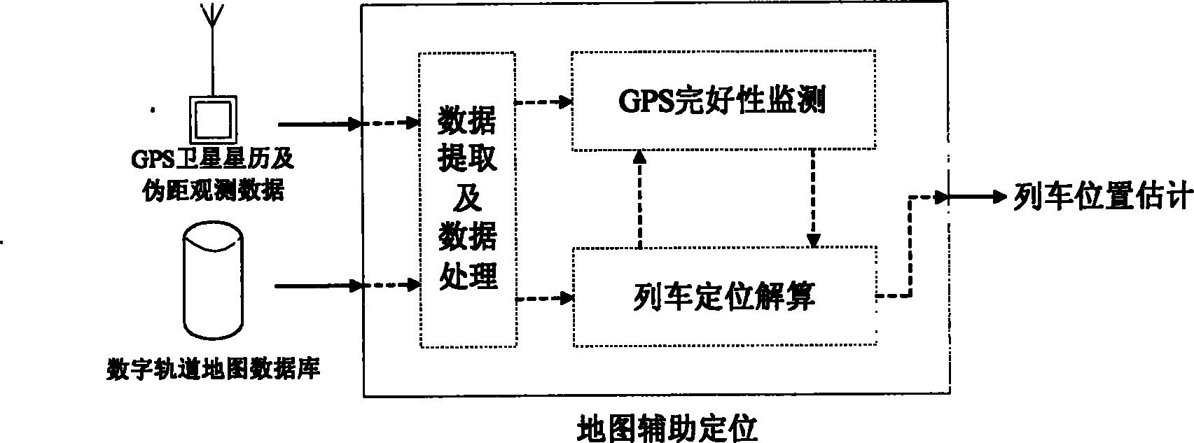
[0085] Embodiment 1: as figure 1 As shown, the core of the digital track map-assisted train positioning method studied in the present invention is the map-assisted train positioning algorithm. The map-assisted train positioning system can be roughly divided into three modules: data extraction and processing, GPS integrity monitoring and train positioning calculation. These three modules, although structurally independent, are interrelated in each computing cycle. The map-assisted train positioning system includes two main sub-algorithms, the digital track map-assisted GPS integrity monitoring algorithm and the train positioning solution algorithm. The input of the system includes: observation data such as satellite ephemeris and pseudorange from GPS receivers, and a digital orbit map database containing precise geographic information of orbits. The output of the system is an estimate of the train's position.
Embodiment 2
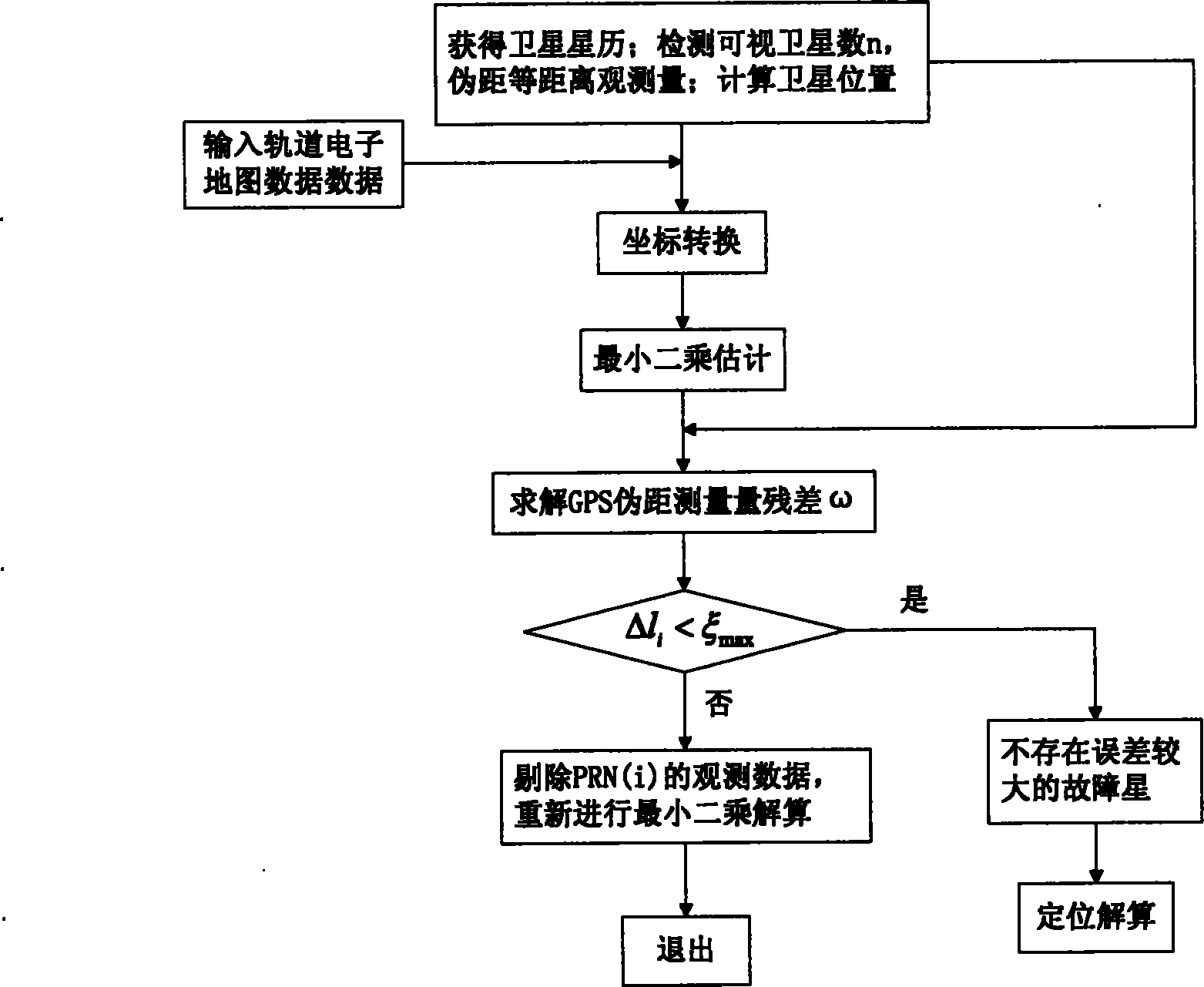
[0086] Embodiment 2 is attached figure 2 As shown, the present invention is further described in detail through specific embodiments. In one embodiment, the specific flow of the GPS integrity monitoring algorithm assisted by the digital track map according to the present invention is as follows:
[0087] 1. Collect ephemeris data and pseudo-range observations of visible satellites, and calculate the position coordinates of visible satellites. Specifically, the NovAtel GPS receiver is used to collect the ephemeris data and pseudo-range observation data of the visible satellites, and extract the relevant parameters in the satellite ephemeris to calculate the position coordinates of the visible satellites;
[0088] 2. Extraction and processing of track map information. In one embodiment, the train lane occupancy information is obtained by the station interlocking system, the map information of the corresponding lane is extracted from the track map database, and these map infor...
Embodiment 3
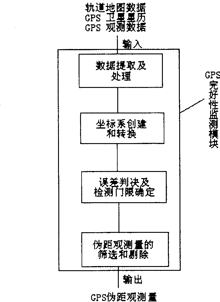
[0092] Embodiment 3 is attached image 3 As shown, the GPS integrity monitoring algorithm of the present invention can be summed up and described as following 4 main submodules: data extraction and processing module, data extraction and data processing module are used for extracting and processing satellite ephemeris and pseudorange from GPS receiver Observational data, as well as data input from the digital orbit map database containing precise orbital geographic information; and calculate the position coordinates of visible satellites and be responsible for the extraction and processing of orbit map information; the processed data is input into the GPS integrity monitoring module , the GPS monitoring module is responsible for establishing a local coordinate system based on the track line, and converting the train position from WGS-84 coordinates to a new local coordinate system based on the track; the error judgment and detection threshold determination module is responsible ...
PUM
 Abstract
Description
Claims
Application Information
 - R&D
- Intellectual Property
- Life Sciences
- Materials
- Tech Scout
- Unparalleled Data Quality
- Higher Quality Content
- 60% Fewer Hallucinations
Browse by: Latest US Patents, China's latest patents, Technical Efficacy Thesaurus, Application Domain, Technology Topic, Popular Technical Reports.
© 2025 PatSnap. All rights reserved.Legal|Privacy policy|Modern Slavery Act Transparency Statement|Sitemap|About US| Contact US: help@patsnap.com


