Real time extracting method for satellite remote sensing sea fog characteristic quantity

An extraction method and satellite remote sensing technology, applied in the field of marine environment monitoring, can solve the problems of separation of no fog and low clouds, inability to extract sea fog feature quantities, and inability to provide information for sea fog dispersal forecasts, etc., to achieve spectral resolution improvement and enhancement The effect of observation and recognition ability

Inactive Publication Date: 2009-05-06
OCEAN UNIV OF CHINA
View PDF0 Cites 30 Cited by
  • Summary
  • Abstract
  • Description
  • Claims
  • Application Information

AI Technical Summary

Problems solved by technology

However, the existing technology does not separate the fog from the low cloud, and essentially does not invert the characteristic quantity of the sea fog, and the change of the characteristic quantity of the sea fog is related to the generation and disappearance of the sea fog. According to the optical thickness of the sea fog, the effectiv

Method used


Image

  • Real time extracting method for satellite remote sensing sea fog characteristic quantity
  • Real time extracting method for satellite remote sensing sea fog characteristic quantity
  • Real time extracting method for satellite remote sensing sea fog characteristic quantity

Examples


Embodiment Construction

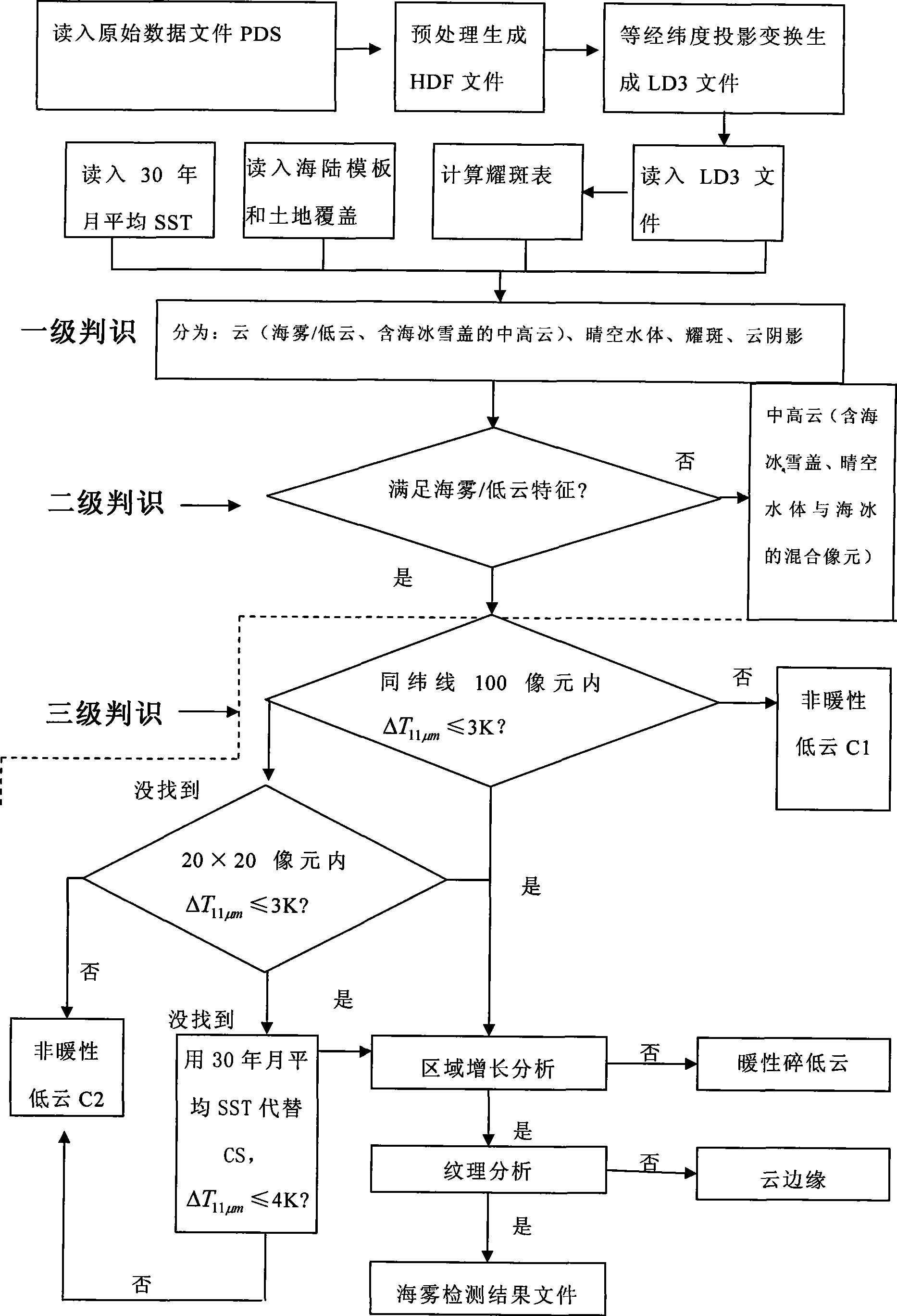
[0010] Such as figure 1 , the concrete steps of the present invention are as follows:

[0011] 1) The data acquisition is obtained and read into the PDS file through the polar-orbiting satellite digital visual broadcasting system (DVBS).

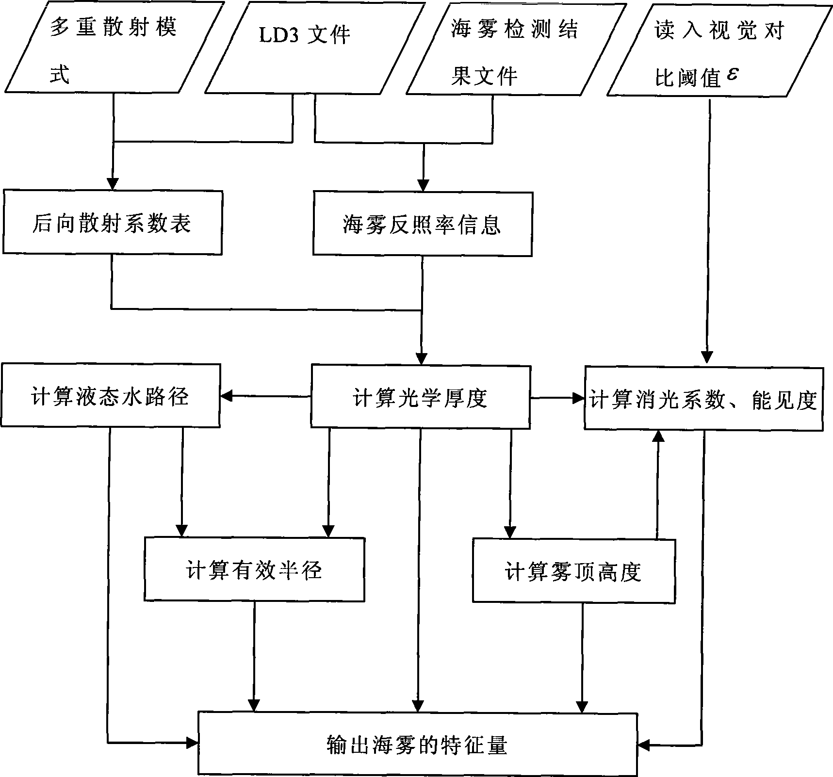
[0012] 2) Read in the solar zenith angle, solar azimuth angle, satellite zenith angle, satellite azimuth angle, geographic positioning data, and calibration data parameters from the header file of the PDS data set file, and use conventional methods to perform data pre-processing on the PDS file. Processing and quality control (streak removal, data scaling and positioning, etc.). HDF files are generated after preprocessing and quality control; then the HDF files are geometrically fine-corrected using a common method to generate a local equilateral longitude and latitude projection data file LD3, which includes the sun zenith angle, satellite zenith angle and sun satellite Relative azimuth information and spectral data information of each ch...


PUM


Abstract

The invention relates to a real-time extracting method of satellite remote sensing sea fog characteristic quantity, daytime EOS/MODIS data is used and is read into a raw data file PDS, the difference of sea fog and low cloud on a spectral characteristic is analyzed in two steps that: firstly, the sea fog and the low cloud are separated, and then, the sea fog characteristic quantity is extracted, namely that a three-level identifying method is adopted to orderly filter high cloud, middle cloud, low cloud, a cloudless water body, a solar flare water body, a cloud shadow area, a sea ice and a snow cover, the sea fog detection is established, a sea fog distributing area is obtained, a file which comprises a sea fog detecting result is generated, then, the sea fog characteristic quantity of the optical thickness of a fog area, the effective radius of fog and a liquid water path are calculated according to a formula, and pictures are displayed on a microcomputer. The method not only extracts the sea fog characteristic quantity, but also can calculate the visibility and the fog top height of the fog, consequently, the quantification detection of the sea fog is realized, and a dissipation forecast of the sea fog supplies meteorological information for air safety above the sea, maritime traffic and coastal airport operation.

Description

technical field [0001] The invention belongs to marine environment monitoring technology, in particular to a method for real-time extraction of satellite remote sensing sea fog feature quantities. Background technique [0002] Sea fog is a common weather phenomenon in my country's coastal waters. When there is sea fog, water vapor condensation produces a large number of fog droplets suspended above the sea surface, and the scattering and reflection of fog droplets reduce the visibility of the sea surface, which has an important impact on human sea activities. [0003] Existing studies have shown that foreign literature reports use channels 1, 3 and 4 of the AVHRR (Very High Resolution Radiometer) of NOAA satellites to invert satellite remote sensing data to obtain fog and low clouds with a certain spatial generality (following Abbreviated as fog / low cloud) feature quantities: fog / low cloud droplet effective radius re, optical thickness τ, liquid water path LWP (Liquidwater ...

Claims


Application Information

Patent Timeline
IPC IPC(8): G01S17/95
CPCY02A90/10
Inventor 张苏平吴晓京刘应辰张莫生张纪伟刘诗军
Owner OCEAN UNIV OF CHINA
Why Eureka
Try Eureka