Daytime and nighttime sea fog detecting method based on polarorbiting meteorological satellite remote sense

A technology of meteorological satellite and detection method, applied in the field of marine environment monitoring

Inactive Publication Date: 2009-06-10
NAT SATELLITE METEOROLOGICAL CENT +1
View PDF0 Cites 24 Cited by
  • Summary
  • Abstract
  • Description
  • Claims
  • Application Information

AI Technical Summary

Problems solved by technology

All kinds of satellite monitoring at home and abroad make comprehensive use of the above channel data, but currently only sea fog and low cloud (abbreviated as: sea fog / low cloud) can be identified as the same target

Method used


Image

  • Daytime and nighttime sea fog detecting method based on polarorbiting meteorological satellite remote sense
  • Daytime and nighttime sea fog detecting method based on polarorbiting meteorological satellite remote sense

Examples


Embodiment Construction

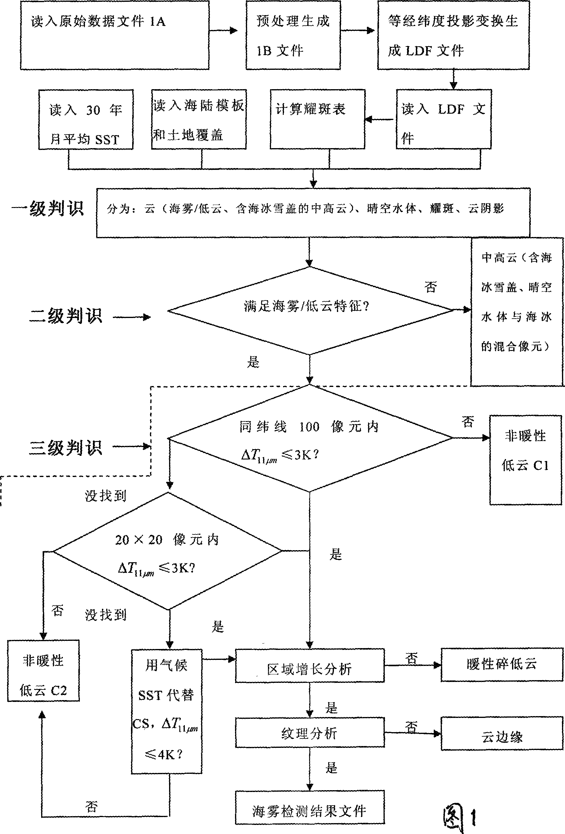
[0019] As shown in Figure 1, the specific steps of the present invention are as follows:

[0020] 1) Data collection is to obtain 1A files (NOAA16-18 satellites); or 1B files (FY1D satellites) through the Polar Orbiting Weather Satellite Digital Visual Broadcasting System (DVBS).

[0021] 2) Use conventional methods to preprocess the data: read the solar zenith angle, solar azimuth angle, satellite zenith angle, satellite azimuth angle, geolocation data, and calibration data from the header file of the FY1D or NOAA satellite data set file Parameters: Use conventional methods for data preprocessing and quality control of 1B files, including stripe removal, data calibration and positioning. The preprocessed and quality controlled file is HDF, and then the HDF file is projected with equal latitude and longitude using a common method Transform, generate the local projection data set file LDF, where the LDF file contains the sun zenith angle, satellite zenith angle and the relative azi...


PUM


Abstract

The present invention relates to a method for detecting sea fog at daytime and night with polar-orbiting meteorological satellite. The polar-orbiting satellite information is used. The original data file is read into. The medium-high cloud, the clear-air water, the solar flare water, the cloud shadow areas, the sea-ice-snow sheets, non-warm low clouds, warm broken low clouds and wind edges are respectively filtered with a three-stage determining method through comprehensively using the multi-channel optical spectrum information, NDVI index, NDSI index and average month SST in thirty years. The sea fog arrangement areas are obtained and the file comprising sea fog detecting result is generated. Namely the image display can be executed on a microcomputer with GRADS drawing software. The method according to the invention separates the sea fog from low cloud thereby realizing the real-time monitoring of sea fog. Effective meteorological information with real time monitoring is provided for the safe flying over sea surface, marine traffic transportation, seaport and coasting airport operation.

Description

Technical field [0001] The invention belongs to marine environment monitoring technology, and specifically relates to a method for detecting sea fog during the day and night by remote sensing of polar orbiting meteorological satellites. Background technique [0002] According to the regulations of the China Meteorological Administration's "Ground Meteorological Observation Regulations", fog refers to "a large number of tiny water droplets floating in the air, often appearing milky white, so that the horizontal visibility is less than 1.0km". In terms of its physical nature, both fog and clouds are the products of condensation of water vapor in the air. Therefore, when the fog rises and leaves the ground, it becomes a cloud, and when the cloud drops to the ground, it is called fog. Among them, clouds can be subdivided into fog, low clouds, and medium-high clouds. Due to the low temperature and the large difference between the phase state of the particles and the fog, the medium-hi...

Claims


Application Information

Patent Timeline
Patent Type & Authority Applications(China)
IPC IPC(8): G01S17/95
CPCY02A90/10
Inventor 吴晓京张苏平李三妹张莫生任素玲曹治强刘应辰
Owner NAT SATELLITE METEOROLOGICAL CENT
Why Eureka
Try Eureka