Intelligent geological calamity synthetic monitoring system and multi-stage prediction analysis method

A technology for comprehensive monitoring of geological disasters, applied in geophysical surveying, seismology, alarms, etc.

Inactive Publication Date: 2009-07-08
INST OF MOUNTAIN HAZARDS & ENVIRONMENT CHINESE ACADEMY OF SCI
View PDF0 Cites 77 Cited by
  • Summary
  • Abstract
  • Description
  • Claims
  • Application Information

AI Technical Summary

Problems solved by technology

[0007] There are many single-item or dual-item monitoring instruments in China for geological disaster monitoring, and their application in forecasting is subject to some limitations

Method used


Image

  • Intelligent geological calamity synthetic monitoring system and multi-stage prediction analysis method
  • Intelligent geological calamity synthetic monitoring system and multi-stage prediction analysis method
  • Intelligent geological calamity synthetic monitoring system and multi-stage prediction analysis method

Examples


Embodiment Construction

[0040] Below in conjunction with accompanying drawing, the present invention will be further described:

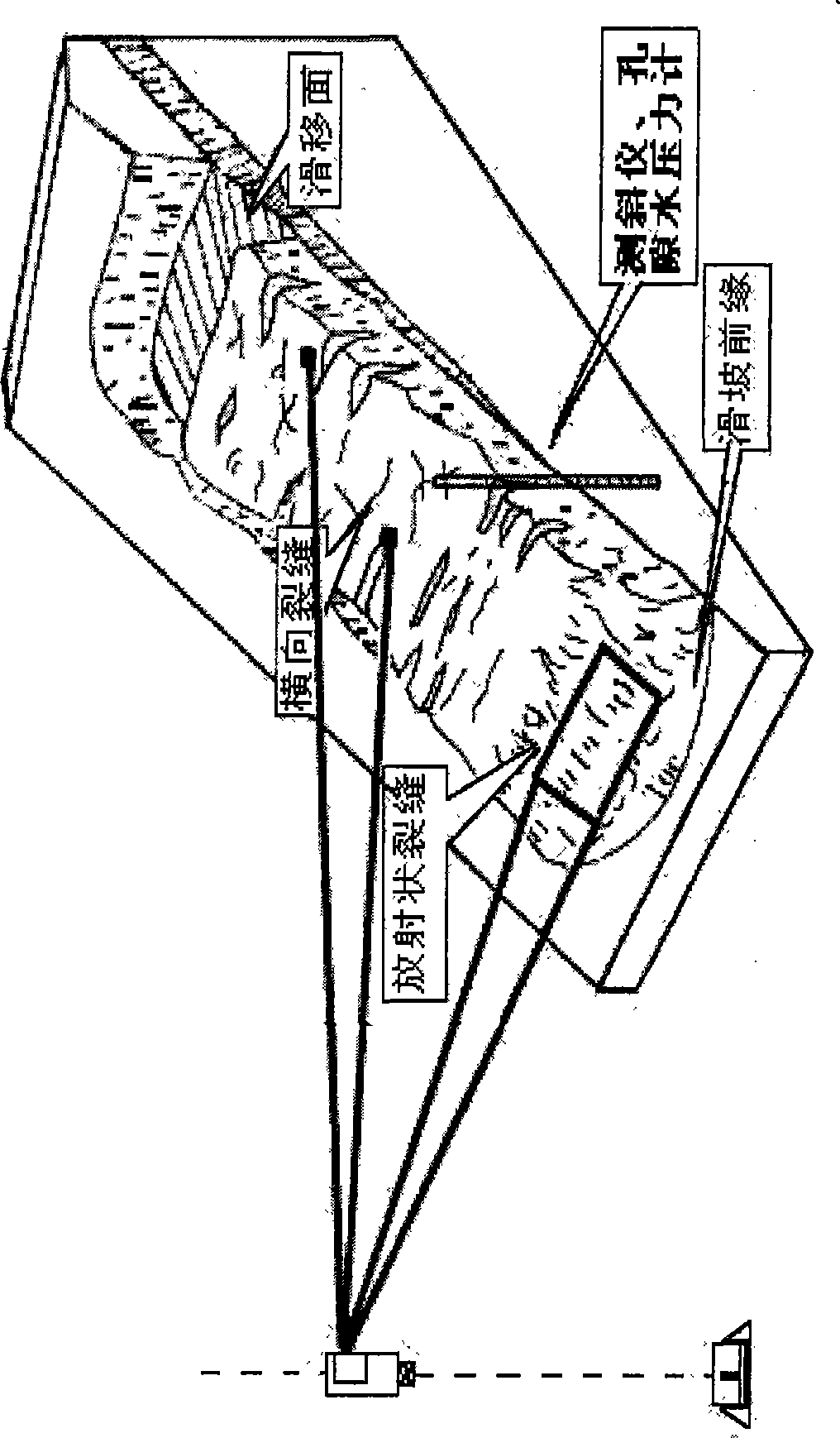
[0041] figure 1 Shown is a schematic diagram of the monitoring method of an intelligent geological disaster comprehensive monitoring system;

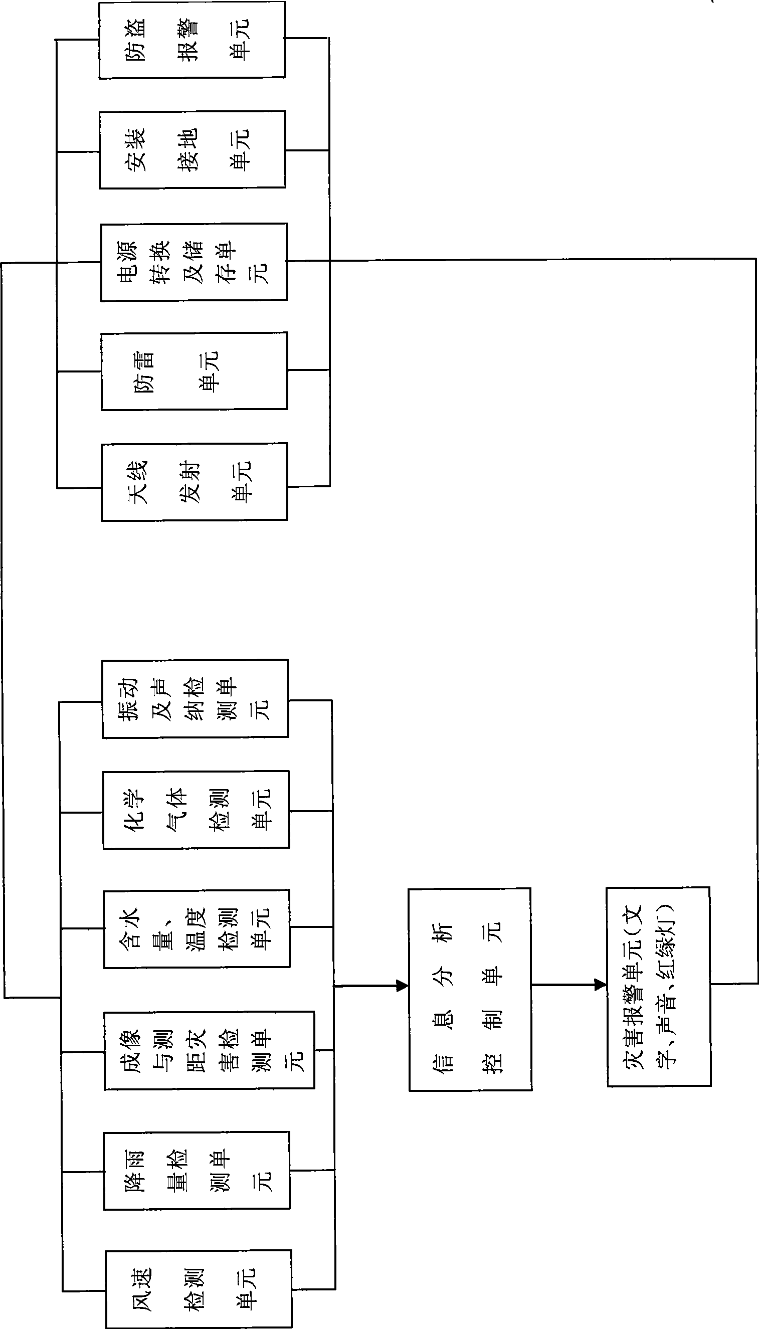
[0042] figure 2 It shows a hardware block diagram of an intelligent geological disaster comprehensive monitoring system, including,

[0043] Deep deformation monitoring unit: use a single-multipoint wireless inclinometer and bury it on the slope or disaster body through drilling (boreholes) (the burial position and buried depth depend on the specific conditions of the disaster body), regularly measure and wirelessly transmit the deep part of the slope Deformation information is received and analyzed in the system, which is used to monitor the early deformation and damage mode, depth and range of slopes; imaging and ranging disaster detection unit: adopts laser scanner, regularly and continuously scans to obtain images in the moni...


PUM


Abstract

The invention discloses an intelligent geologic hazard comprehensive monitoring system and a multi-level forecast analyzing method. The system is a monitoring device which can be assembled and disassembled according to the requirement, and is applicable to outdoor assembly. The system is a shaft after assembly, measures in fixed time and wirelessly transmits information of slope underground depth deformation to a system information analysis control unit form the ground, acquires an image in a monitoring area by continuously scanning in fixed time by a laser scanner, and is provided with a multipoint fixed point ranging laser to carry out accurate range measurement on a selected object. The system and the method take the geologic hazard underground depth deformation and ground surface direct deformation displacement as main monitoring forecast foundation, and divide hazard forecast into four levels, namely a preparing level, a pre-warning level, an early forecast level and a hazard forecast level by combining with assistant parameters and induction factors of physical and chemical field variations, thereby integrally completing the functions of monitoring, analyzing and forecasting on site.

Description

technical field [0001] The invention belongs to the technical field of physical automatic control, in particular to an intelligent geological disaster comprehensive monitoring system and a multi-level forecasting and analysis method. Background technique [0002] Geological disaster monitoring is a comprehensive technology that integrates the formation mechanism of geological disasters, monitoring instruments, space-time technology and prediction and forecasting technology. At present, the research and application of monitoring technology methods for geological disasters at home and abroad are mostly carried out around sudden geological disasters such as collapses, landslides, and debris flows. [0003] Monitoring methods are mainly divided into four categories based on the type of parameters for detection. The first is disaster body deformation monitoring, including monitoring methods that mainly measure displacement and deformation information: such as deep underground de...

Claims


Application Information

Patent Timeline
Patent Type & Authority Applications(China)
IPC IPC(8): G01V1/00G01V1/40G01W1/14G08B21/10
CPCY02A90/10
Inventor 赵宇崔鹏段晓康
Owner INST OF MOUNTAIN HAZARDS & ENVIRONMENT CHINESE ACADEMY OF SCI
Why Eureka
Try Eureka