

Method for automatically updating land-use map based on historical data and remote sensing data
A technology of historical data and remote sensing data, applied in the directions of maps/plans/charts, educational tools, instruments, etc., it can solve the problems of large change detection errors and the inability to automate the update of land use maps, so as to achieve automation and improve the automatic update process. , the effect of broad market prospects and application value
Inactive Publication Date: 2011-01-05
REMOTE SENSING APPLIED INST CHINESE ACAD OF SCI
View PDF0 Cites 1 Cited by
- Summary
- Abstract
- Description
- Claims
- Application Information
AI Technical Summary
Problems solved by technology
The present invention provides a method for automatically updating land use maps based on historical data and remote sensing data, which is used to solve the problem of large change detection errors caused by purely using remote sensing images as data sources in the prior art, and relying on manual field surveys and visual interpretation. Determining Land Use Changes Does Not Automate Land Use Map Updates
Method used
View moreImage
Smart ImageViewing Examples


Examples
Embodiment Construction
Login to View More PUM
 Abstract
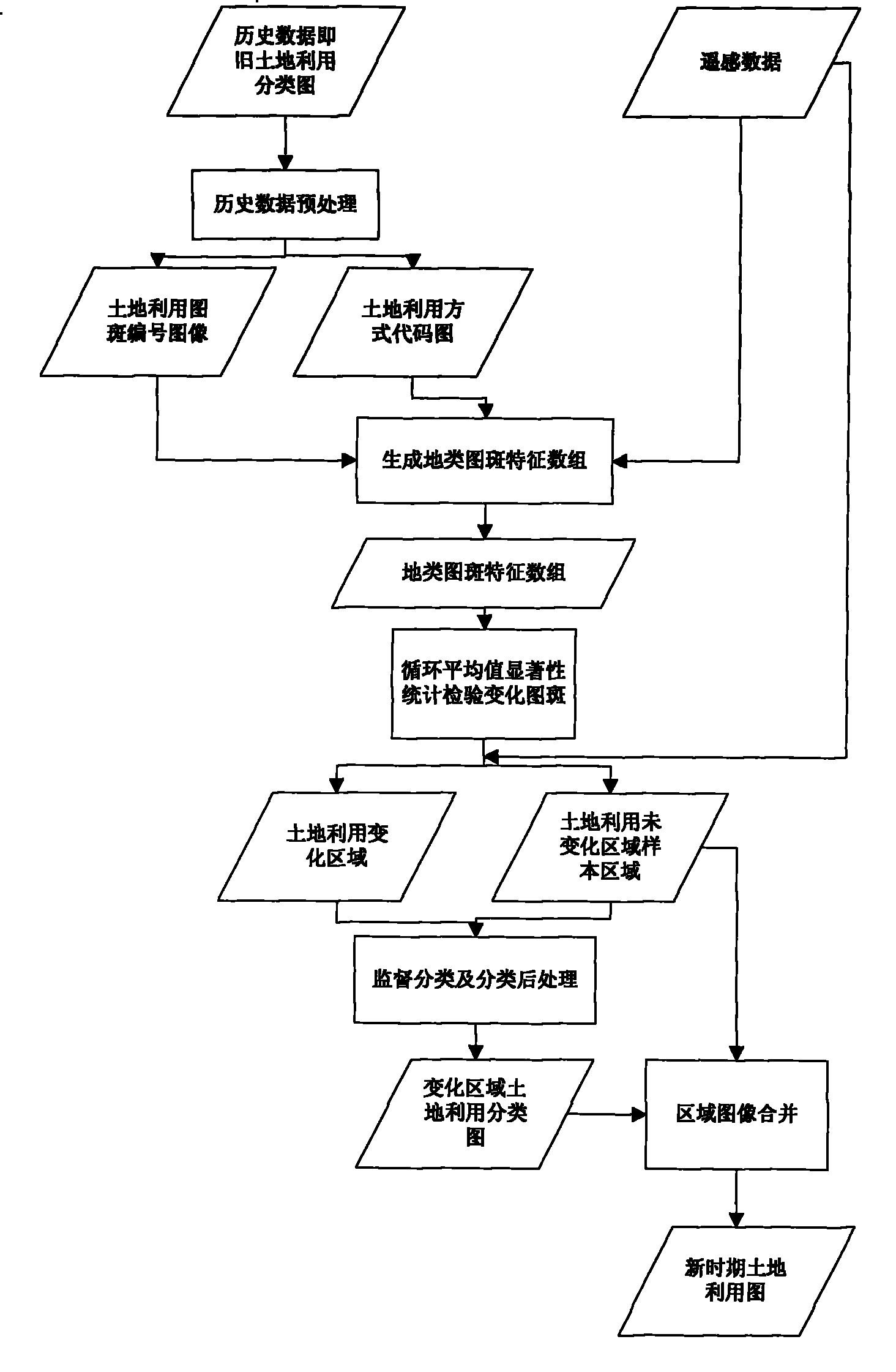
The invention relates to an automatic updating method of a land-use map based on historical data and remote sensed data. Firstly historical data is pre-processed to obtain a land-use patch number map and a land-use mode code map which are overlapped with a remote sensed image first main component map, and various land-use mode patch feature structure arrays are obtained through calculation; changed patches are detected by adopting a cycle average value significance statistical test method; land-use unchanged regions are used as the samples of land-use interest regions; and minimum distance supervised classification is performed to land-use changed regions to obtain the land-use maps of the changed regions, and the land-use maps of the changed regions are united with the images of and-use unchanged regions to obtain new land-use maps. The automatic updating method adopts two data sources, improves the variation test precision, realizes the updating automation of the land-use maps, can be applied to the departments of land and resources to update a great amount of land-use map data, quickly test the land-use variation, and has wide market prospect and application value.
Description
An Automatic Update Method of Land Use Map Based on Historical Data and Remote Sensing Data Technical field An automatic update method of land use maps based on historical data belongs to the field of digital image processing technology, and particularly relates to land use change detection technology and digital image classification technology. Background technique The land use map reflects various information about land use in a certain area during a period. It provides the latest land use basic data for land and resources management, is an important reference basis for various major policy formulations, and is the source data for many scientific research institutions. It is of great significance to its research. (Refer to the literature: Gu Fenghua, Zhang Jixian, Li Haitao. Application of Multi-source Remote Sensing Data in the Update of Land Use Maps--Taking Huairou District as an example. Science of Surveying and Mapping, 2006, 31(6): 68-69) The automatic update method o...
Claims
Login to View More Application Information
Patent Timeline
 Patent Type & AuthorityPatents(China)
IPC IPC(8): G09B29/00G06K9/62
Inventor谢仁伟牛铮占玉林
OwnerREMOTE SENSING APPLIED INST CHINESE ACAD OF SCI