Pavement distress investigating and treating method

A treatment method and disease technology, applied in the field of pavement disease investigation, can solve problems such as inability to effectively complete detection of narrow parts, uneconomical investigation, high labor intensity, etc.

Active Publication Date: 2009-10-28
河南省高等级公路养护工程研究中心
View PDF0 Cites 19 Cited by
  • Summary
  • Abstract
  • Description
  • Claims
  • Application Information

AI Technical Summary

Problems solved by technology

The problems that these two methods exist are: 1) manual investigation is that technicians carry measuring equipment to carry out on-site data collection and record it in the form, and the later stage arranges and calculates the collected data according to the evaluation standard to obtain the result. This method has low work efficiency and labor The intensity is high, and users cannot obtain the location information of road surface diseases in a timely, fast and accurate manner; 2) The survey results are processed through programs, and the disease data cannot be directly output, and the results are not timely and intuitive; The workload can be completed accurately and quickly, which greatly improves the work efficiency, but this investigation method needs to cooperate with expensive inspection vehicles, and it cannot effectively complete the inspection for narrow parts such as ramps of expressways, and it is used for the investigation of low-grade highways not economical

Method used


Image

  • Pavement distress investigating and treating method
  • Pavement distress investigating and treating method
  • Pavement distress investigating and treating method

Examples


Embodiment 1

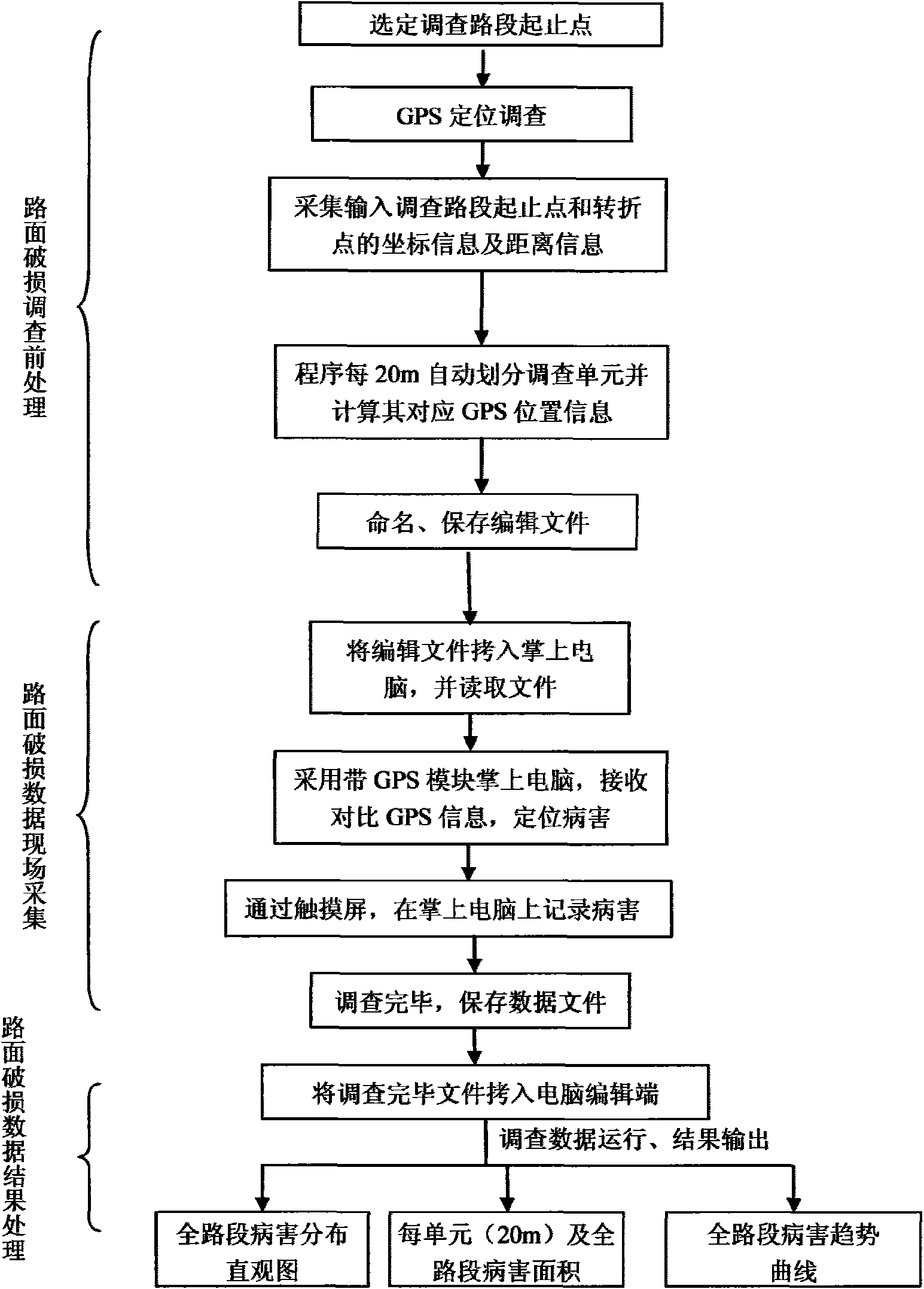
[0046] Embodiment one: see Figure 1 ~ Figure 3 . In this embodiment, a certain section of expressway in Henan Province is taken as a test and investigation road section, and the implementation process of the road surface disease investigation and treatment method of the present invention is specifically described.

[0047] 1. Obtaining information on survey road sections:

[0048] First, run the Google earth map on a computer connected to the Internet, find the road section that needs to be investigated, and find out the coordinates of the starting point, turning point and end point of this road on Google earth (coordinate information can be displayed in the lower left corner of the Google earth map ), and use the distance calculation tool that comes with Google earth to calculate the distance from the starting point to each turning point.

[0049] 2. Divide the investigation section into sections in the computer:

[0050] The coordinate information of the road section is ...

Embodiment 2

[0062] Embodiment two: see figure 1 . In the road surface disease investigation and processing method of this embodiment, on the basis of determining the investigation road section, by running the electronic satellite map program on the computer connected to the network, the coordinates of the starting point, route turning point and end point of the investigated road section are found on the electronic map, and use The distance calculation tool calculates the distance from the starting point to each turning point, and then passes the coordinate information of the road section through the computer processing program, according to the following formula:

[0063] l = ( y 2 - y 1 ) 2 + ( ...

Embodiment 3

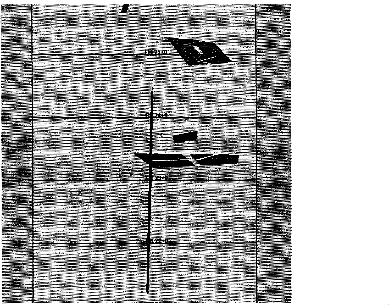
[0069] Embodiment three: see figure 1 . The road surface disease investigation and processing method in this embodiment is a further optimization on the basis of Embodiment 2: when performing statistical calculations on the road surface diseases in each certain length of the road section with a set distance on the computer, for the area where the disease performance is one, Select the points on the handheld computer screen to select the edge points of the disease and then form an area area, and use the following formula to determine the size of the disease area S 1 calculate:

[0070] S 1 = 1 2 Σ i = 1 N h x i y i + 1 - x ...


PUM


Abstract

The invention relates to a pavement distress investigating and data treating method which is based on global positioning satellite (GPS) technology or utilizes reference substances along a road for positioning. The method comprises the steps: based on the determination of an investigated road section, electronic satellite map programs are firstly operated on a networking computer to find out the coordinates of a staring point, a route turning point and a terminal point of the investigated road section, or information on reference substances (such as villages, gas stations, crossings, bridges and the like) at both sides of the road are obtained on a detailed road traffic map; and then information on the length of the road section is calculated and the investigated road section is sectionalized; information about the investigation of the road section is led into a handheld computer which is then used for recording information on the positions of pavement distress with different marks respectively according to the distress profile field and also conducting distress investigation and statistics; and distress data counted by the handheld computer are opened on the computer, pavement distress within preset distance of each certain length is respectively counted and calculated and then datasheet and charts obtained from analysis are stored in the computer.

Description

1. Technical field: [0001] The invention relates to a road surface disease investigation method, in particular to a road surface disease investigation and data processing method based on GPS satellite positioning technology or based on the positioning technology of reference objects on both sides of the road, and using a handheld computer to conduct on-site disease investigation. 2. Background technology: [0002] At present, with the continuous development and improvement of the social and economic level, the traffic road environment between cities, countries and even villages has undergone rapid changes, and the global world has become a "global village". Leaving aside the railways, roads are the lifeblood of urban and rural areas all over the world, including highways, highways of all levels, urban municipal roads, and even Airbus aircraft are inseparable from the construction of airports and runways. Since highways of all levels are important passages for passenger trans...

Claims


Application Information

Patent Timeline
Patent Type & Authority Applications(China)
IPC IPC(8): E01C23/01
Inventor 刘廷国李志栋田科史纪村维塔利
Owner 河南省高等级公路养护工程研究中心
Why Eureka
Try Eureka