
High-precision point positioning method and system for global navigation satellite system (GNSS)

A global navigation satellite, single-point positioning technology, applied in the field of satellite positioning, can solve problems such as inability to meet high-precision measurement and precise navigation, limited operating range, long observation time, etc., to achieve broad industrialization prospects, high social and economical effect of benefit

Inactive Publication Date: 2009-11-18
CHINA ZHENGYUAN GEOMATICS CO LTD
View PDF0 Cites 34 Cited by
  • Summary
  • Abstract
  • Description
  • Claims
  • Application Information

AI Technical Summary

Problems solved by technology

[0003] The working modes of satellite positioning mainly include: traditional static positioning mode, which has a long observation time per point and high precision (up to mm level), which is suitable for high-precision control point measurement; real-time dynamic differential positioning (RTK) mode, This method has the characteristics of high precision and fast speed, but the working range is limited, generally no more than 15 kilometers, and it needs to establish a base station and real-time data communication, so the scope of use is limited; for ordinary single-point positioning, use a The positioning of the instrument is convenient and efficient, but it can only achieve a positioning accuracy of 10m in the plane and 15m in elevation, which is suitable for low-precision navigation and cannot meet the needs of high-precision measurement and precise navigation
However, there is currently no high-precision single-point positioning technology compatible with Beidou / GPS / GLONASS / Galileo satellite navigation systems

Method used


Image

  • High-precision point positioning method and system for global navigation satellite system (GNSS)
  • High-precision point positioning method and system for global navigation satellite system (GNSS)

Examples


Embodiment Construction

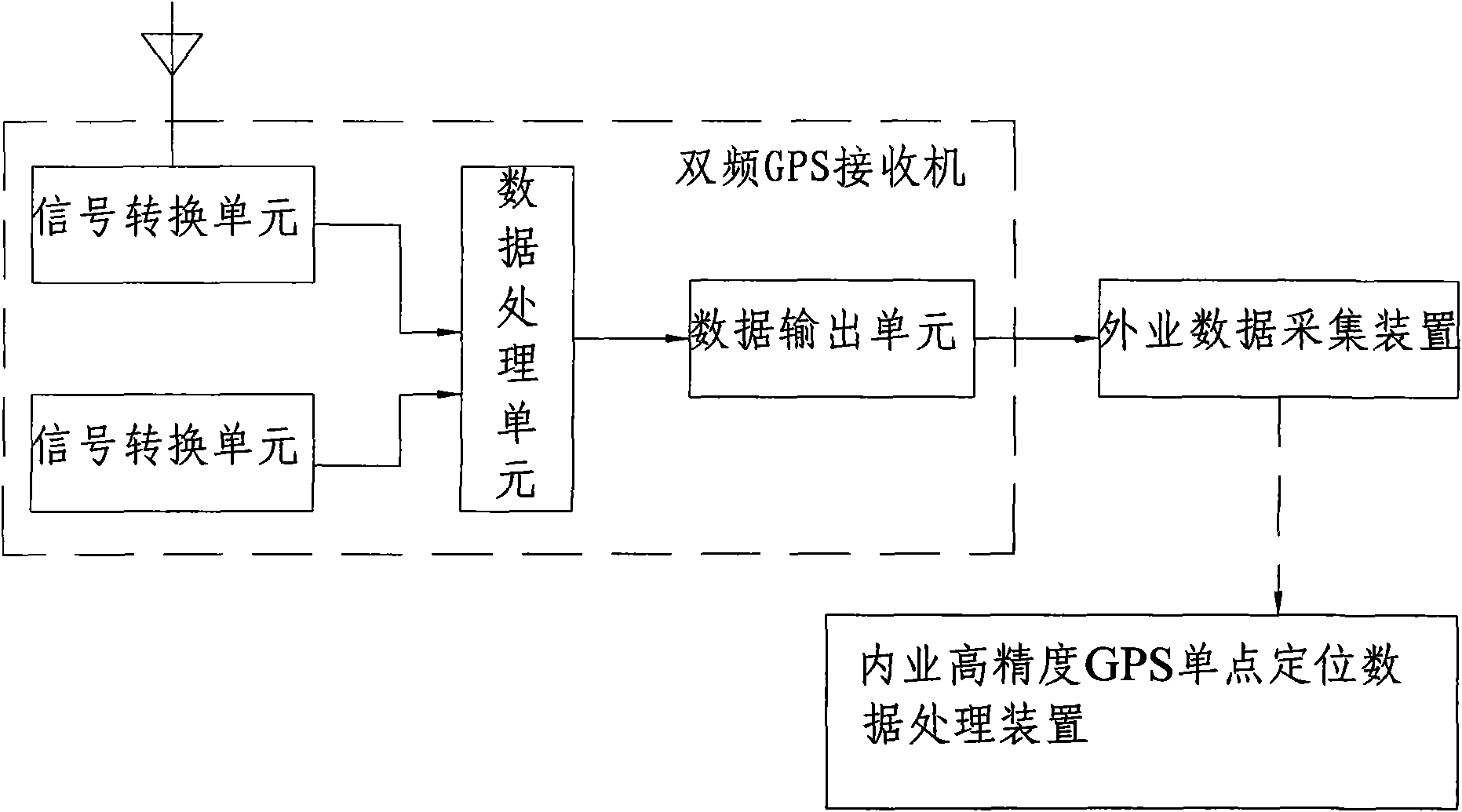
[0029] like figure 1 As shown, the global navigation satellite system (GNSS) high-precision single-point positioning system includes:

[0030] An antenna for receiving signals from Beidou, GPS, GLONASS, and Galileo satellite navigation systems;

[0031] A dual-frequency GPS receiver; the dual-frequency GPS receiver includes:

[0032] The storage module is used to store the observation value positioning equations common to Beidou, GPS, GLONASS and Galileo satellite navigation systems and the mutual conversion parameters of the coordinate system and time system of each satellite navigation system;

[0033] The signal conversion unit is used to convert the received signals of each satellite navigation system into digital signals;

[0034] The data processing unit is used to read the mutual conversion parameters and the observation value positioning equation in the storage module to process the digital signal, use the tropospheric model to weaken the delay of the neutral atmosph...


PUM


Abstract

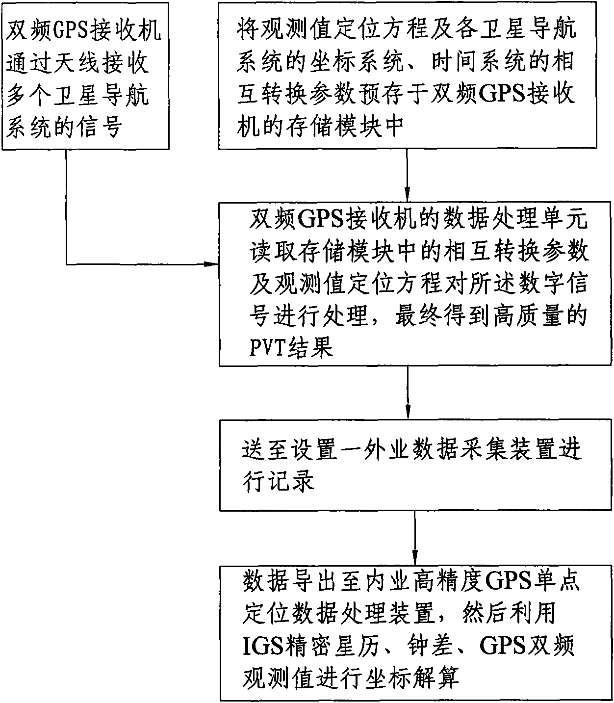
The invention provides a high-precision point positioning method and a high-precision point positioning system for a global navigation satellite system (GNSS). The method comprises the following steps: prestoring an observed value positioning equation with commonality for a compass navigation satellite system, a GPS, a GLONASS and a Galileo satellite navigation system, and interconvertible parameters of coordinate systems and time systems of the various satellite navigation systems into a storage module of a double-frequency GPS receiver; receiving signals of the various satellite navigation systems by the double-frequency GPS receiver through an antenna, and converting the signals into digital signals by a signal converting unit; reading the interconvertible parameters in the storage module and the observed value positioning equation by a data processing unit to process the digital signals; finally obtaining a high-quality PVT result; realizing the combination use of observed quantities and ephemerides of the various satellite navigation systems; and sending the PVT result to a field data acquisition device for recording. The method and the system realize the compatible high-precision point positioning based on the compass navigation satellite system / the GPS / the GLONASS / the Galileo satellite navigation system, and can provide point positioning position information with higher quality.

Description

technical field [0001] The invention relates to the technical field of satellite positioning, in particular to a global navigation satellite system (GNSS) high-precision single-point positioning method and system. Background technique [0002] Since the establishment of the Global Positioning System (GPS) in 1993, satellite positioning technology has been widely used in mobile target monitoring, measurement, navigation, timing, space technology, etc., and has become the third new IT growth point after communications and the Internet. Location-based information service (LBS) will be one of the broadest, most potential and most attractive development directions of satellite navigation and positioning technology in the future. Following GPS, the former Soviet Union established the GOLNASS satellite positioning system, the European Union is building the GALILEO satellite positioning system, and my country is developing the Beidou (BEIDOU) navigation satellite system. Internatio...

Claims


Application Information

Patent Timeline
IPC IPC(8): G01S1/02G01S5/02
Inventor 司少先郭际明杨玉坤巢佰崇崔洪涛罗年学刘学伟
Owner CHINA ZHENGYUAN GEOMATICS CO LTD
Learn More