Digital photography measurement image-control point-distributing method based on GPS/INS

A photogrammetry and GPS base station technology, applied in the field of aerial photogrammetry, can solve the problems of not being able to reflect the advantages of DMC digital cameras, increasing the workload of field image control points, and shrinking baselines, so as to reduce field control points and reduce mapping Cost, the effect of reducing system errors

Inactive Publication Date: 2010-02-10
XIAN MEIHANG INFORMATION IND
View PDF0 Cites 8 Cited by
  • Summary
  • Abstract
  • Description
  • Claims
  • Application Information

AI Technical Summary

Problems solved by technology

When the aerial area and photographic scale are the same, the number of aerial photographs taken by DMC digital cameras is more than that of traditional film. Therefore, the traditional method of measuring and laying out image control points is no longer suitable for DMC digital cameras. First, due to the existing technical specifications It cannot guide the layout of DMC digital image control measurement, let alone reflect the advantages of DMC digi

Method used


Image

  • Digital photography measurement image-control point-distributing method based on GPS/INS
  • Digital photography measurement image-control point-distributing method based on GPS/INS
  • Digital photography measurement image-control point-distributing method based on GPS/INS

Examples


Embodiment 1

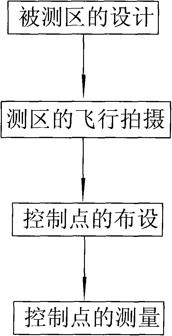
[0043] Such as figure 1 As shown, the present invention is a kind of method based on GPS / INS digital photogrammetry image control distribution point, it is characterized in that, comprises the following steps:

[0044] Step 1, the design of the measured area: including base station layout, inspection field layout and flight route planning; wherein, the base station layout is to lay out 2 GPS base stations in the GPS network points above D level in the measured area, and determine the GPS base station and The relative position of surveying area makes the oblique distance between surveying area and 2 GPS base stations no more than 20 kilometers respectively; Described calibration field layout is to select the calibration field position in the measured area; Described flight path planning is Plan the route according to the topography of the measured area;

[0045]Step 2. Flight shooting of the survey area: Under the navigation and positioning of the airborne GPS / INS combined sys...

Embodiment 2

[0056] Using the above method, we surveyed and collected data in the Rongcheng survey area, and compared with the data in the Tongchuan survey area, some statistics are as follows.

[0057] Table 3: Statistical Table of Accuracy of GPS / INS Auxiliary Beam Block Adjustment in Tongchuan and Rongcheng Survey Areas

[0058]

[0059] It can be seen from the comparison of statistical data in Table 3 that in the Rongcheng survey area, we used four regular area network statistics with routes and baselines of 16*63, 16*58, 16*54, and 16*48 respectively. 16*45 area network scale accuracy. The error plane of the redundant control points of these four regional networks is about 14.3cm and the elevation is about 10.3cm, and the accuracy is very close to the error plane of 18.6cm and the elevation of 9.9cm in the redundant control points of the 16*45 regional network in Tongchuan survey area , but the maximum difference plane of the redundant control points of the four regional networks ...


PUM


Abstract

The invention discloses a digital photography measurement image-control point-distributing method based on a GPS/INS. The method comprises the following steps: step 1, designing a measured area: comprising base station arrangement, calibration field arrangement and flight course planning; step 2, shooting the measured area in flight; step 3, arranging control points of a calibration field and control points of the measured area: arranging at least 6 flat height control points and 3 flat height inspection points at the periphery of the calibration field in arranging the control points of the calibration field; arranging 1 flat height control point at the four corners of a regular area net with at most 21 flight courses and at most 69 baselines respectively in arranging the control points ofthe measured area; and step 4, measuring the control points. The invention has simple operation and high work efficiency, can meet the accuracy requirement, can reduce the arrangement of open-air control points, quickens the imaging speed, lowers the big scale mapping cost and also solves the technical problems of image control, measurement and point distribution of digital images based on a DMC.

Description

technical field [0001] The invention belongs to the technical field of aerial photogrammetry, and relates to a digital photogrammetry image control distribution method, in particular to a GPS / INS-based digital photogrammetry image control distribution method. Background technique [0002] In recent years, with the rapid development of digital imaging technology, the large-format frame-type digital aerial imaging system represented by Z / IImaging's DMC (Digital Microcircuit) system has been rapidly promoted and applied. Compared with the film system, it has the following characteristics: [0003] (1) Image information with high quality (signal-to-noise ratio and high contrast), high geometry, high radiometric resolution (ground resolution up to 5 cm, radiometric resolution greater than 8 bits / pixel) and high image overlap rate can be obtained , images with a large overlap rate are conducive to improving the accuracy and reliability of image matching, thereby greatly improving...

Claims


Application Information

Patent Timeline
IPC IPC(8): G01C11/00
Inventor 苗小利白志刚苏向晨吕军超安军原喜屯汤丽刘玉琦任为民马永健
Owner XIAN MEIHANG INFORMATION IND
Why Eureka
Try Eureka